Lake Tekapo
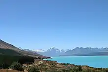
Lake Tekapo is the second-largest of three roughly parallel lakes running north–south along the northern edge of the Mackenzie Basin in the South Island of New Zealand (the others are Lake Pukaki and Lake Ohau). It covers an area of 83 square kilometres (32 sq mi), and is at an altitude of 710 metres (2,330 ft) above sea level.

| Lake Tekapo | |
|---|---|
 Lake Tekapo | |
 Lake Tekapo | |
 Location of Lake Tekapo | |
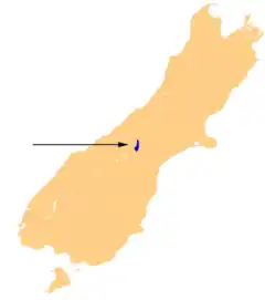
| Location | Mackenzie District, Canterbury region, South Island |
| Coordinates | 43°53′S 170°31′E |
| Primary inflows | Godley River (north), Macauley River (north), Mistake River (west), Cass River (west)[1] |
| Primary outflows | Tekapo River |
| Catchment area | 1,463 km2 (565 sq mi)[1] |
| Basin countries | New Zealand |
| Max. length | 27 km (17 mi)[1] |
| Max. width | 6 km (3.7 mi) (max), 3.5 kilometres (2.2 mi) (mean)[1] |
| Surface area | 87 km2 (34 sq mi) (summer), 82 km2 (32 sq mi) (winter),[1] |
| Average depth | 69 m (226 ft)[1] |
| Max. depth | 120 m (390 ft)[1] |
| Water volume | 6 km3 (4.9×10⁶ acre⋅ft)[1] |
| Surface elevation | 710 m (2,330 ft) |
| Settlements | Lake Tekapo |
| References | [1] |
The lake is fed at its northern end by the braided Godley River, which has its source in the Southern Alps to the north. The lake is a popular tourist destination, and several resort hotels are located at the township of Lake Tekapo at the lake's southern end. The Lake Tekapo Regional Park, administered by Environment Canterbury, is located on the southern shore of the lake. It is also known for its stunning seasonal display of Lupin that bloom along its shores around Mid November.
An astronomical observatory is located at Mount John, which is to the north of the town, and south of the small Lake Alexandrina.
Hydroelectricity
The lake's original outflow was at its southern end, into the Tekapo River. In 1938 construction commenced on a power station, originally due to be finished in 1943 but halted in 1942 by the world war. At the same time, control gates were constructed to regulate outflows to the Waitaki Dam downstream. Work restarted in 1944, and the power station, now known as Tekapo A, came online in 1951.
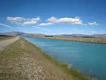
Water from the lake is diverted through a 1.4-kilometre (4,600 ft) tunnel under the town to the power station, with the water originally being returned to the river. With development of the Upper Waitaki hydroelectric scheme in the 1970s, water is now fed into a 26-kilometre (16 mi) canal which leads to Tekapo B on the shores of Lake Pukaki.[2]
Following a turbine failure in 1986, a new Kaplan turbine was installed, with a more efficient design and higher output (42 000 HP) than the original. Today, the power station produces an average of 160 GWh annually, from a 25.2 MW capacity generator. The net head of the station is 30.5 m.
In 2008 Tekapo A and Tekapo B hydro stations were refurbished following the upgrade of Benmore and Waitaki.[3]
On 1 June 2011, Tekapo A and B hydro power stations were transferred from Meridian Energy to Genesis Energy on instruction from the Government.[4]
Skifield
On the north side of the lake, 24 km from the Tekapo township is the Roundhill Ski Area, which caters primarily to beginner and intermediate skiers.
Bronze sheepdog
.jpg.webp)
Close to the Church of the Good Shepherd is a well-known bronze statue of a New Zealand Collie sheepdog. The statue was commissioned by Mackenzie Country residents in recognition of the indispensable role of the sheepdog in their livelihoods. The sculptor was Innes Elliott of Kaikoura, with a dog called Haig, belonging to a neighbour, being the model. Elliott reported the sculpting process took approximately fifteen months. Clay for the model came from the insulator works in Temuka, with a plaster cast of it made and sent to London in 1966, where the statue was cast. [5]
Church of the Good Shepherd
Situated on the shores of Lake Tekapo is the Church of the Good Shepherd, which, in 1935, was the first church built in the Mackenzie Basin. The church at Lake Tekapo was designed by Christchurch architect R.S.D. Harman, based on sketches by a local artist, Esther Hope. The church is one of the most photographed in New Zealand, and features an altar window that frames views of the lake and mountains.[6]
References
- Irwin, J. (September 1978). "Bottom sediments of Lake Tekapo compared with adjacent Lakes Pukaki and Ohau, South Island, New Zealand" (PDF). N.Z. Journal of Marine and Freshwater Research. 12 (3). pp. 245–250. Retrieved 9 November 2007.
- "Tekapo". Genesis Energy. Retrieved 25 January 2019.
- Bruce, David (30 October 2008). "Benmore gets more with first full rebuild". Otago Daily Times. Retrieved 30 October 2008.
- "Genesis Energy set to acquire Tekapo A and B power stations". Genesis Energy. 13 May 2011. Archived from the original on 13 October 2011. Retrieved 3 March 2012.
- Elliott, Innes (1967). "Statue to a Working Sheepdog". In Henderson, Jim (ed.). Return To Open Country. A.H & A.W. Reed. pp. 48–49. ISBN 0589003062.
- "Church of the Good Shepherd". Register of Historic Places. Heritage New Zealand. Retrieved 31 December 2019.
External links
 Media related to Lake Tekapo at Wikimedia Commons
 Lake Tekapo travel guide from Wikivoyage
- Official Lake Tekapo Tourism Website
- "Church of the Good Shepherd". Register of Historic Places. Heritage New Zealand.
- MacKenzie Region New Zealand
- MacKenzie District Council