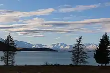
Lake Tekapo (town)
Lake Tekapo (often known simply as Tekapo to avoid confusion with the lake itself) is a small town (township) located at the southern end of the lake of the same name in the inland South Island of New Zealand. It had 558 residents according to the 2018 census, being one of five settlements in the sparsely populated Mackenzie Basin.[1]
Lake Tekapo | |
|---|---|
Rural settlement | |
.jpg.webp) | |
 Lake Tekapo | |
| Coordinates: 44°00′S 170°29′E | |
| Country | New Zealand |
| Region | Canterbury |
| Territorial authority | Mackenzie District |
| Population (2018) | |
| • Total | 558 |
| Postcode(s) | 7999 |
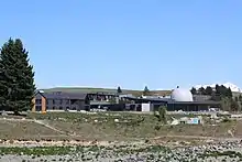
SH 8 runs directly through the township – 227 km from Christchurch and 256 km from Queenstown. Daily shuttle services link Lake Tekapo to Christchurch and Queenstown. The lake is a popular tourist destination, and several resort hotels are located at the township. Lake Tekapo Airport is located 5 km west of the town. Chartered flights are available at locally based Air Safaris.[2] Twizel lies 60km (39 minutes drive) south of Lake Tekapo via Lake Pukaki and Burkes Pass lies 21km (15 minutes drive) west along state highway 8.
History
The Māori were the first people to discover the Mackenzie Basin. The name Tekapo derives from the te reo Māori words taka (sleeping mat) and po (night). The Mackenzie Basin became known to Europeans in 1855 when, in order to find a less conspicuous route, James Mackenzie, a Scottish sheep thief, ventured inland and discovered the high country that now bears his name. In 1857, John and Barbara Hay established the first sheep farm in Mackenzie on the shore of Lake Tekapo.[3]
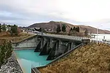
Lake Tekapo township started to grow after the construction of hydropower stations in the 1930s. The project was delayed due to World War II, but it was eventually completed and commissioned in 1951.[3] The control gates built across the outlet of Lake Tekapo regulate the amount of water entering the Tekapo River. These were completed in 1940. State Highway 8 runs across the top of them.[4]
Tekapo is expected to grow significantly over the next 30 years. The MacKenzie District Council expects the district’s population will jump from 4950 to 9050, dwellings 3872 to 6120, jobs 1876 to 4618, and peak day visitors 17,378 to 61,253.[5]
Climate
Lake Tekapo has an oceanic climate (Köppen climate classification: Cfb) with mild, sunny summers and cool winters, sometimes snowing in the township once or twice a year. On average, Lake Tekapo has 2180 sunshine hours (200 hours more than the New Zealand average) and 78 rain days producing 600 mm rainfall annually.[1] Temperature is generally warm in summer and extremely cold in winter, by New Zealand standards.
| Climate data for Lake Tekapo (1981−2010) | |||||||||||||
|---|---|---|---|---|---|---|---|---|---|---|---|---|---|
| Month | Jan | Feb | Mar | Apr | May | Jun | Jul | Aug | Sep | Oct | Nov | Dec | Year |
| Average high °C (°F) | 21.6 (70.9) |
21.3 (70.3) |
18.7 (65.7) |
14.9 (58.8) |
10.7 (51.3) |
7.0 (44.6) |
5.8 (42.4) |
8.3 (46.9) |
11.9 (53.4) |
14.5 (58.1) |
17.2 (63.0) |
19.4 (66.9) |
14.3 (57.7) |
| Daily mean °C (°F) | 15.2 (59.4) |
14.8 (58.6) |
12.4 (54.3) |
9.2 (48.6) |
5.9 (42.6) |
2.6 (36.7) |
1.4 (34.5) |
3.6 (38.5) |
6.5 (43.7) |
8.8 (47.8) |
11.1 (52.0) |
13.2 (55.8) |
8.7 (47.7) |
| Average low °C (°F) | 8.7 (47.7) |
8.3 (46.9) |
6.1 (43.0) |
3.5 (38.3) |
1.1 (34.0) |
−1.8 (28.8) |
−3.0 (26.6) |
−1.1 (30.0) |
1.1 (34.0) |
3.0 (37.4) |
5.1 (41.2) |
7.0 (44.6) |
3.2 (37.8) |
| Average precipitation mm (inches) | 43.6 (1.72) |
35.9 (1.41) |
48.8 (1.92) |
45.2 (1.78) |
56.5 (2.22) |
60.0 (2.36) |
49.6 (1.95) |
58.4 (2.30) |
50.4 (1.98) |
49.5 (1.95) |
41.3 (1.63) |
52.2 (2.06) |
591.6 (23.29) |
| Average precipitation days (≥ 1.0 mm) | 5.8 | 5.3 | 5.5 | 6.0 | 6.7 | 7.5 | 6.5 | 7.4 | 7.3 | 7.6 | 6.2 | 7.1 | 78.9 |
| Average relative humidity (%) | 66.8 | 74.9 | 75.3 | 76.9 | 78.7 | 83.9 | 83.1 | 81.2 | 72.5 | 68.7 | 65.0 | 67.4 | 74.5 |
| Mean monthly sunshine hours | 253.8 | 220.9 | 230.9 | 199.4 | 145.4 | 139.9 | 149.7 | 170.1 | 200.0 | 231.7 | 241.5 | 234.0 | 2,417.4 |
| Source: NIWA Climate Data[6] | |||||||||||||
Demographics
The Tekapo settlement had a usual resident population of 558 at the 2018 New Zealand census, an increase of 195 people (53.7%) since the 2013 census, and an increase of 240 people (75.5%) since the 2006 census. There were 273 males and 285 females, giving a sex ratio of 0.96 males per female. Of the total population, 57 people (10.2%) were aged up to 15 years, 180 (32.3%) were 15 to 29, 270 (48.4%) were 30 to 64, and 51 (9.1%) were 65 or older.[7]
In terms of ethnicity, 60.2% were European/Pākehā, 3.8% were Māori, 1.1% were Pacific peoples, 32.3% were Asian, and 8.1% were other ethnicities (totals add to more than 100% since people could identify with multiple ethnicities).[7]
Attractions
Mount John University Observatory
.jpg.webp)
Selected for its very clear atmosphere, large number of clear sky nights, and relative freedom from light pollution, Mount John University Observatory is located on a small hill to the north of the town, and south of the small Lake Alexandrina. Originally set up by the University of Pennsylvania (looking for a southern hemisphere location), it is now operated by the University of Canterbury. From 1969 to 1982, the United States Air Force had a satellite tracking station adjacent to the observatory. In June 2012, an area of 430,000 hectares (1,100,000 acres) around Tekapo was declared the Aoraki Mackenzie International Dark Sky Reserve by the International Dark-Sky Association, one of only four such reserves around the world.[8]
Star gazing tours
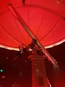
The Dark Sky Project runs star gazing tours from their award winning[9] observatory building on the foreshore of Lake Tekapo. The observatory building contains a restored the Brashear Telescope. It is built of brass, iron, steel and wood and stands nine meters high. It has an 18-inch refracting lens. The Brashear telescope was built in 1894. This telescope was brought to New Zealand in 1963 by the University of Pennsylvania and the University of Canterbury. [10][11]
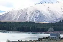
Tekapo Hot Springs
Tekapo Hot Springs is a major tourist attraction. It has three hot pools designed for soaking in, which range in temperature from 36.5 to 38.5 degrees Celsius. These are designed in the shape of Lake Ohau, Lake Pukaki and Lake Tekapo. A further two cooler pools are designed for children and a splash pad is also present. Tekapo Hot Springs also has an ice skating rink and a snow tubing park.
Skiing
Roundhill Ski Area is located on the Two Thumb Range overlooking Lake Tekapo. It is approximately 32 kilometers from Lake Tekapo Village. Roundhill's base is at 1350 meters above sea level and the highest poin the lifts rise to is 2133 meters above sea level. It comprises 550 hectares of terrain.
Church of the Good Shepherd
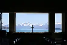
The Church of the Good Shepherd was built in 1935. Now, it opens to the public from 9am to 5pm during summer (Oct to Apr) and 10am to 4pm in winter (May to Sept). Next to it is a statue, which is dedicated to the working collies of Mackenzie. This was commissioned on 7 March 1968.[1]
Lake Tekapo foot bridge
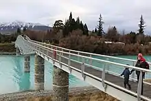
The $2 million, 125-metre bridge was opened in 2015. This crosses the Tekapo River and connects the Church of the Good Shepherd with the rest of the Lake Tekapo township.[12]
Military base
The New Zealand Army has a large training range located near Tekapo. It is used for general military exercises and for pre-deployment training of forces being sent to Afghanistan.[13]
Government
Tekapo is part of the Waitaki electorate.[14] The MacKenzie District Council is responsible for providing local government services to Lake Tekapo.[15]
References
- "Information on Lake Tekapo". Tekapo Tourism. Retrieved 11 April 2013.
- "Tekapo Tourism - Lake Tekapo". Tekapo Tourism. 2013. Retrieved 11 April 2013.
- "History of Mackenzie Country". Department of Conservation. Retrieved 11 April 2013.
- "Hydro generation at Lake Tekapo with the Tekapo A and Tekapo B power stations". www.tekapotourism.co.nz. Retrieved 8 November 2020.
- "Mackenzie District Council releases growth projections report". Stuff. 9 September 2020. Retrieved 15 September 2020.
- "Climate Data and Activities". NIWA. Retrieved 19 October 2013.
- "Age and sex by ethnic group (grouped total response), for census usually resident population counts, 2006, 2013, and 2018 Censuses (urban rural areas)". nzdotstat.stats.govt.nz. Retrieved 13 September 2020.
- "New Zealand's Aoraki Mackenzie Named World's Largest International Dark Sky Reserve" (PDF). International Dark Sky Association. 9 June 2012. Archived from the original (PDF) on 10 July 2012. Retrieved 13 June 2012.
- Saturday; October 2020, 31; Building, 7:28 am Press Release: NZ Institute of. "NZIOB Congratulates The Winners Of The 2020 NZ Building Industry Awards | Scoop News". www.scoop.co.nz. Retrieved 8 November 2020.CS1 maint: numeric names: authors list (link)
- "Brashear Telescope - Restored Masterpiece". Dark Sky Project. Retrieved 8 November 2020.
- "Tekapo's Dark Sky Project attraction combines Māori astronomy and science". Stuff. 1 July 2019. Retrieved 8 November 2020.
- "Lake Tekapo Footbridge reopened". Stuff. 9 December 2015. Retrieved 8 November 2020.
- "Lake Tekapo". New Zealand A to Z. 11 April 2013. Retrieved 11 April 2013.
- "Waitaki: Electoral Profile - New Zealand Parliament". www.parliament.nz. Retrieved 12 October 2020.
- "Mackenzie Tomorrow - Community Outcomes". www.mackenzie.govt.nz. Retrieved 12 October 2020.
| Wikivoyage has a travel guide for Lake Tekapo. |