Lam Thap District
Lam Thap District (Thai: ลำทับ, pronounced [lām tʰáp]) is a district (amphoe) of Krabi Province, southern Thailand.
Lam Thap
ลำทับ | |
|---|---|
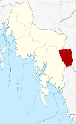 District location in Krabi Province | |
| Coordinates: 8°4′18″N 99°17′30″E | |
| Country | Thailand |
| Province | Krabi |
| Seat | Lam Thap |
| Area | |
| • Total | 320.708 km2 (123.826 sq mi) |
| Population (2005) | |
| • Total | 20,069 |
| • Density | 62.6/km2 (162/sq mi) |
| Time zone | UTC+7 (ICT) |
| Postal code | 81190 |
| Geocode | 8107 |
History
The minor district (king amphoe) Lam Thap was established on 30 June 1984, when the two tambons Lam Thap and Din Udom were split off from Khlong Thom District.[1] It was upgraded to a full district on 4 November 1993.[2]
Geography
Neighboring districts are (from the west clockwise): Khlong Thom and Khao Phanom of Krabi Province; Thung Yai and Bang Khan of Nakhon Si Thammarat Province; and Wang Wiset of Trang Province.
Administration
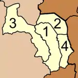
The district is divided into four sub-districts (tambons), which are further subdivided into 27 villages (mubans). Lam Thap is a township (thesaban tambon) and covers parts of tambons Lam Thap and Thung Sai Thong. There are a further four tambon administrative organizations (TAO).
|
 |
References
- ประกาศกระทรวงมหาดไทย เรื่อง แบ่งท้องที่อำเภอคลองท่อม จังหวัดกระบี่ ตั้งเป็นกิ่งอำเภอลำทับ (PDF). Royal Gazette (in Thai). 101 (95 ง): 2268. July 24, 1984.
- พระราชกฤษฎีกาตั้งอำเภอลำทับ อำเภอร่องคำ อำเภอเวียงแหง อำเภอนาโยง อำเภอแก้งสนามนาง อำเภอโนนแดง อำเภอบ้านหลวง อำเภอกะพ้อ อำเภอศรีบรรพต อำเภอแก่งกระจาน อำเภอหนองสูง อำเภอสบเมย อำเภอเมยวดี อำเภอโคกเจริญ อำเภอทุ่งหัวช้าง อำเภอผาขาว อำเภอวังหิน อำเภอดอนพุด อำเภอบึงโขงหลง และอำเภอห้วยคต พ.ศ. ๒๕๓๖ (PDF). Royal Gazette (in Thai). 110 (179 ก special): 1–3. November 3, 1993.