Laveyrune
Laveyrune is a commune in the Ardèche department in southern France. The Robert Louis Stevenson Trail (GR 70), a popular long-distance path, runs through the village.[2]
Laveyrune | |
|---|---|
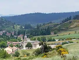 Church and village from the south | |
Location of Laveyrune 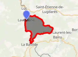
| |
 Laveyrune  Laveyrune | |
| Coordinates: 44°37′59″N 3°53′46″E | |
| Country | France |
| Region | Auvergne-Rhône-Alpes |
| Department | Ardèche |
| Arrondissement | Largentière |
| Canton | Haute-Ardèche |
| Government | |
| • Mayor (2008–2014) | Jean-Marie Jourdan |
| Area 1 | 13.44 km2 (5.19 sq mi) |
| Population (2017-01-01)[1] | 107 |
| • Density | 8.0/km2 (21/sq mi) |
| Time zone | UTC+01:00 (CET) |
| • Summer (DST) | UTC+02:00 (CEST) |
| INSEE/Postal code | 07136 /48250 |
| Elevation | 974–1,365 m (3,196–4,478 ft) (avg. 977 m or 3,205 ft) |
| 1 French Land Register data, which excludes lakes, ponds, glaciers > 1 km2 (0.386 sq mi or 247 acres) and river estuaries. | |
Population
| Year | Pop. | ±% |
|---|---|---|
| 1962 | 9 | — |
| 1968 | 127 | +1311.1% |
| 1975 | 108 | −15.0% |
| 1982 | 84 | −22.2% |
| 1990 | 112 | +33.3% |
| 1999 | 126 | +12.5% |
| 2008 | 133 | +5.6% |
See also
References
- "Populations légales 2017". INSEE. Retrieved 6 January 2020.
- Castle, Alan (2007). The Robert Louis Stevenson Trail (2nd ed.). Cicerone. p. 112. ISBN 978-1-85284-511-7.
| Wikimedia Commons has media related to Laveyrune. |
This article is issued from Wikipedia. The text is licensed under Creative Commons - Attribution - Sharealike. Additional terms may apply for the media files.