Saint-Andéol-de-Fourchades
Saint-Andéol-de-Fourchades is a commune in the Ardèche department in the Auvergne-Rhône-Alpes region in southern France.
Saint-Andéol-de-Fourchades | |
|---|---|
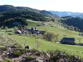 A general view of Saint-Andéol-de-Fourchades | |
Location of Saint-Andéol-de-Fourchades 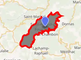
| |
 Saint-Andéol-de-Fourchades  Saint-Andéol-de-Fourchades | |
| Coordinates: 44°50′58″N 4°17′59″E | |
| Country | France |
| Region | Auvergne-Rhône-Alpes |
| Department | Ardèche |
| Arrondissement | Tournon-sur-Rhône |
| Canton | Haut-Eyrieux |
| Government | |
| • Mayor (2008–2014) | Josyane Allard Chalencon |
| Area 1 | 16.47 km2 (6.36 sq mi) |
| Population (2017-01-01)[1] | 53 |
| • Density | 3.2/km2 (8.3/sq mi) |
| Time zone | UTC+01:00 (CET) |
| • Summer (DST) | UTC+02:00 (CEST) |
| INSEE/Postal code | 07209 /07160 |
| Elevation | 727–1,486 m (2,385–4,875 ft) (avg. 1,029 m or 3,376 ft) |
| 1 French Land Register data, which excludes lakes, ponds, glaciers > 1 km2 (0.386 sq mi or 247 acres) and river estuaries. | |
Population
|
|
See also
References
- "Populations légales 2017". INSEE. Retrieved 6 January 2020.
| Wikimedia Commons has media related to Saint-Andéol-de-Fourchades. |
| Authority control |
|---|
This article is issued from Wikipedia. The text is licensed under Creative Commons - Attribution - Sharealike. Additional terms may apply for the media files.