Le Lion-d'Angers
Le Lion-d'Angers is a commune in the Maine-et-Loire department in western France. On 1 January 2016, the former commune of Andigné was merged into Le Lion-d'Angers.[2]
Le Lion-d'Angers | |
|---|---|
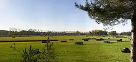 A general view of Le Lion-d'Angers | |
.svg.png.webp) Coat of arms | |
Location of Le Lion-d'Angers 
| |
 Le Lion-d'Angers  Le Lion-d'Angers | |
| Coordinates: 47°37′43″N 0°42′42″W | |
| Country | France |
| Region | Pays de la Loire |
| Department | Maine-et-Loire |
| Arrondissement | Segré |
| Canton | Tiercé |
| Intercommunality | Vallées du Haut-Anjou |
| Government | |
| • Mayor (2020–2026) | Étienne Glémot |
| Area 1 | 47.74 km2 (18.43 sq mi) |
| Population (2017-01-01)[1] | 4,924 |
| • Density | 100/km2 (270/sq mi) |
| Demonym(s) | Lionnais, Lionnaise |
| Time zone | UTC+01:00 (CET) |
| • Summer (DST) | UTC+02:00 (CEST) |
| INSEE/Postal code | 49176 /49220 |
| Elevation | 17–78 m (56–256 ft) (avg. 13 m or 43 ft) |
| 1 French Land Register data, which excludes lakes, ponds, glaciers > 1 km2 (0.386 sq mi or 247 acres) and river estuaries. | |
Geography
The river Oudon forms part of the commune's southern border before joining the river Mayenne, which forms part of the commune's eastern border.
References
- "Populations légales 2017". INSEE. Retrieved 6 January 2020.
- Arrêté préfectoral Archived 2016-12-20 at the Wayback Machine 12 August 2015
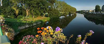
Sunset on the Oudon
| Wikimedia Commons has media related to Le Lion-d'Angers. |
This article is issued from Wikipedia. The text is licensed under Creative Commons - Attribution - Sharealike. Additional terms may apply for the media files.