Montrevault-sur-Èvre
Montrevault-sur-Èvre is a commune in the Maine-et-Loire department in western France. Montrevault is the municipal seat.
Montrevault-sur-Èvre | |
|---|---|
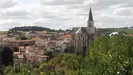 A general view of Montrevault-sur-Èvre | |
Location of Montrevault-sur-Èvre 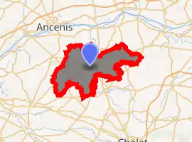
| |
 Montrevault-sur-Èvre  Montrevault-sur-Èvre | |
| Coordinates: 47°15′44″N 1°02′39″W | |
| Country | France |
| Region | Pays de la Loire |
| Department | Maine-et-Loire |
| Arrondissement | Cholet |
| Canton | Beaupréau-en-Mauges |
| Intercommunality | Mauges Communauté |
| Government | |
| • Mayor (2020–2026) | Christophe Dougé |
| Area 1 | 198.85 km2 (76.78 sq mi) |
| Population (2017-01-01)[1] | 15,859 |
| • Density | 80/km2 (210/sq mi) |
| Demonym(s) | Montrebellien, Montrebellienne |
| Time zone | UTC+01:00 (CET) |
| • Summer (DST) | UTC+02:00 (CEST) |
| INSEE/Postal code | 49218 /49110, 49600, 49270 |
| 1 French Land Register data, which excludes lakes, ponds, glaciers > 1 km2 (0.386 sq mi or 247 acres) and river estuaries. | |
History
It was established on 15 December 2015 and consists of the former communes of La Boissière-sur-Èvre, Chaudron-en-Mauges, La Chaussaire, Le Fief-Sauvin, Le Fuilet, Montrevault, Le Puiset-Doré, Saint-Pierre-Montlimart, Saint-Quentin-en-Mauges, Saint-Rémy-en-Mauges and La Salle-et-Chapelle-Aubry.[2]
References
- "Populations légales 2017". INSEE. Retrieved 6 January 2020.
- Arrêté préfectoral 5 October 2015 (in French)
This article is issued from Wikipedia. The text is licensed under Creative Commons - Attribution - Sharealike. Additional terms may apply for the media files.