Leiria District
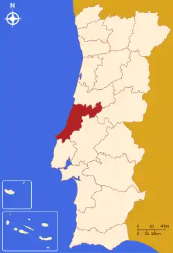
The District of Leiria (Portuguese: Distrito de Leiria [lɐjˈɾi.ɐ] (![]() listen)) is a district located in Centro region of Portugal, divided between the traditional provinces of Beira Litoral and Estremadura. It borders on the north with district of Coimbra, on the east with district of Castelo Branco and with district of Santarém, on the south with district of Lisbon and on the west with the ocean Atlantic. The district capital is the city of Leiria.
listen)) is a district located in Centro region of Portugal, divided between the traditional provinces of Beira Litoral and Estremadura. It borders on the north with district of Coimbra, on the east with district of Castelo Branco and with district of Santarém, on the south with district of Lisbon and on the west with the ocean Atlantic. The district capital is the city of Leiria.
District of Leiria | |
|---|---|
 Coat of arms | |
 | |
| Country | Portugal |
| Region | Centro |
| Historical province | Beira Litoral and Estremadura |
| No. of municipalities | 16 |
| No. of parishes | 148 |
| Capital | Leiria |
| Area | |
| • Total | 3,515 km2 (1,357 sq mi) |
| Population 2011 | |
| • Total | 470,930 |
| • Density | 130/km2 (350/sq mi) |
| ISO 3166 code | PT-10 |
| No. of parliamentary representatives | 10 |
| Name | Status |
|---|---|
| Alcobaça | C |
| Alvaiázere | T |
| Ansião | T |
| Batalha | T |
| Bombarral | T |
| Caldas da Rainha | C |
| Castanheira de Pera | T |
| Figueiró dos Vinhos | T |
| Leiria | C |
| Marinha Grande | C |
| Nazaré | T |
| Óbidos | T |
| Pedrógão Grande | T |
| Peniche | C |
| Pombal | C |
| Porto de Mós | T |
Summary of election results from Leiria district, 1976-2019
| Parties | % | S | % | S | % | S | % | S | % | S | % | S | % | S | % | S | % | S | % | S | % | S | % | S | % | S | % | S | % | S |
|---|---|---|---|---|---|---|---|---|---|---|---|---|---|---|---|---|---|---|---|---|---|---|---|---|---|---|---|---|---|---|
| 1976 | 1979 | 1980 | 1983 | 1985 | 1987 | 1991 | 1995 | 1999 | 2002 | 2005 | 2009 | 2011 | 2015 | 2019 | ||||||||||||||||
| PS | 31.1 | 4 | 23.2 | 3 | 22.7 | 3 | 32.7 | 4 | 19.6 | 2 | 18.7 | 2 | 23.0 | 3 | 36.7 | 4 | 36.8 | 4 | 29.5 | 3 | 35.6 | 4 | 30.1 | 4 | 20.7 | 3 | 24.8 | 3 | 31.1 | 4 |
| PSD | 31.2 | 4 | In AD | 35.6 | 4 | 38.6 | 5 | 60.8 | 9 | 61.2 | 7 | 43.3 | 5 | 42.6 | 5 | 50.8 | 6 | 39.8 | 5 | 34.9 | 4 | 47.0 | 6 | In PàF | 33.5 | 5 | ||||
| CDS-PP | 19.4 | 2 | 16.2 | 2 | 12.2 | 1 | 6.0 | 4.8 | 11.4 | 1 | 9.9 | 1 | 9.8 | 1 | 8.9 | 1 | 12.6 | 1 | 12.8 | 1 | 5.3 | |||||||||
| PCP/APU/CDU | 7.3 | 1 | 10.9 | 1 | 9.7 | 1 | 9.5 | 1 | 7.9 | 1 | 5.9 | 4.5 | 4.5 | 5.3 | 4.1 | 4.6 | 5.1 | 5.0 | 5.1 | 4.3 | ||||||||||
| AD | 56.2 | 7 | 59.8 | 7 | ||||||||||||||||||||||||||
| PRD | 15.3 | 2 | 3.0 | |||||||||||||||||||||||||||
| BE | 1.7 | 2.2 | 5.5 | 9.5 | 1 | 5.1 | 9.7 | 1 | 9.4 | 1 | ||||||||||||||||||||
| PàF | 48.4 | 6 | ||||||||||||||||||||||||||||
| Total seats | 11 | 10 | ||||||||||||||||||||||||||||
| Source: Comissão Nacional de Eleições | ||||||||||||||||||||||||||||||
See also
- Casal de São Simão, a village in the district of Leiria
This article is issued from Wikipedia. The text is licensed under Creative Commons - Attribution - Sharealike. Additional terms may apply for the media files.