Les Collines-de-l'Outaouais Regional County Municipality
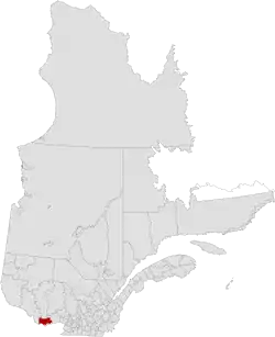
Les Collines-de-l'Outaouais (French for "The hills of the Outaouais") is a regional county municipality in the Outaouais region of western Quebec, Canada. The region nearly encircles the City of Gatineau, which is to the south. Its administrative seat is in Chelsea, Quebec.
Les Collines-de-l'Outaouais | |
|---|---|
 | |
| Coordinates: 45°33′N 75°52′W[1] | |
| Country | |
| Province | |
| Region | Outaouais |
| Effective | December 4, 1991 |
| County seat | Chelsea |
| Government | |
| • Type | Prefecture |
| • Prefect | Robert Bussière |
| Area | |
| • Total | 2,199.30 km2 (849.15 sq mi) |
| • Land | 2,051.77 km2 (792.19 sq mi) |
| Population (2016)[3] | |
| • Total | 49,094 |
| • Density | 23.9/km2 (62/sq mi) |
| • Change 2011-2016 | |
| • Dwellings | 23,164 |
| Time zone | UTC−5 (EST) |
| • Summer (DST) | UTC−4 (EDT) |
| Area code(s) | 819 |
| Website | www |
| [4] | |
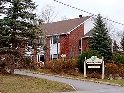
RCM Office in Chelsea
It was created in January 1991 when the Communauté régionale de l'Outaouais (Outaouais Regional Community) was split into Les Collines-de-l'Outaouais RCM and the Communauté urbaine de l'Outaouais (Outaouais Urban Community, now City of Gatineau). The region is home to the majority of Gatineau Park. It is bisected by the Gatineau River which flows from north to south. The Ottawa River forms the southwestern boundary.
Demographics
| Canada census – Les Collines-de-l'Outaouais Regional County Municipality community profile | |||
|---|---|---|---|
| 2016 | 2011 | ||
| Population: | 49,094 (5.8% from 2011) | 46,393 (10.4% from 2006) | |
| Land area: | 2,051.77 km2 (792.19 sq mi) | 2,048.24 km2 (790.83 sq mi) | |
| Population density: | 23.9/km2 (62/sq mi) | 22.7/km2 (59/sq mi) | |
| Median age: | 41.8 (M: 42.1, F: 41.5) | 40.4 (M: 40.6, F: 40.1) | |
| Total private dwellings: | 23,164 | 22,056 | |
| Median household income: | $90,482 | $85,789 | |
| References: 2016[5] 2011[4] earlier[6] | |||
| Year | Pop. | ±% |
|---|---|---|
| 1986 | 20,355 | — |
| 1991 | 28,894 | +42.0% |
| 1996 | 33,680 | +16.6% |
| 2001 | 35,188 | +4.5% |
| 2006 | 42,005 | +19.4% |
| 2011 | 46,393 | +10.4% |
| 2016 | 49,094 | +5.8% |
Transportation
References
- Reference number 269051 of the Commission de toponymie du Québec (in French)
- Geographic code 820 in the official Répertoire des municipalités (in French)
- "Census Profile, 2016 Census: Les Collines-de-l'Outaouais, Municipalité régionale de comté [Census division], Quebec". Statistics Canada. Retrieved December 3, 2019.
- "2011 Community Profiles". 2011 Canadian Census. Statistics Canada. July 5, 2013. Retrieved 2019-12-20.
- "2016 Community Profiles". 2016 Canadian Census. Statistics Canada. February 21, 2017. Retrieved 2019-12-20.
- "2001 Community Profiles". 2001 Canadian Census. Statistics Canada. February 17, 2012.
- Official Transport Quebec Road Map
External links
| Wikimedia Commons has media related to Les Collines-de-l'Outaouais Regional County Municipality. |
Adjacent Counties & Equivalent Territories | ||||||||||
|---|---|---|---|---|---|---|---|---|---|---|
| ||||||||||
| Regional county municipalities and equivalent territories | |
|---|---|
| Municipalities | |
This article is issued from Wikipedia. The text is licensed under Creative Commons - Attribution - Sharealike. Additional terms may apply for the media files.