La Pêche
La Pêche (French pronunciation: [la pɛːʃ], Quebec French pronunciation: [la paɪ̯ʃ]) is a municipality along both sides of the Gatineau River in Les Collines-de-l'Outaouais Regional County Municipality in the Outaouais region of Quebec, Canada, about 30 km (19 mi) north of downtown Gatineau.
La Pêche | |
|---|---|
 | |
 Location within Les Collines-de-l'Outaouais RCM | |
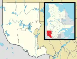 La Pêche Location in western Quebec | |
| Coordinates: 45°41′N 75°59′W[1] | |
| Country | Canada |
| Province | Quebec |
| Region | Outaouais |
| RCM | Les Collines-de-l'Outaouais |
| Constituted | January 1, 1975 |
| Government | |
| • Mayor | Guillaume Lamoureux |
| • Federal riding | Pontiac |
| • Prov. riding | Gatineau |
| Area | |
| • Total | 616.50 km2 (238.03 sq mi) |
| • Land | 585.93 km2 (226.23 sq mi) |
| Population (2016)[3] | |
| • Total | 7,863 |
| • Density | 13.4/km2 (35/sq mi) |
| • Pop 2011-2016 | |
| • Dwellings | 4,665 |
| Time zone | UTC−05:00 (EST) |
| • Summer (DST) | UTC−04:00 (EDT) |
| Postal code(s) | J0X 2W0 |
| Area code(s) | 819 |
| Highways | |
| Website | www |
Bordering on the north side of the Gatineau Park, La Pêche provides multiple access points to this park.
La Pêche was declared Quebec's first and Canada's second fair trade town on November 9, 2007.
Communities
It includes the following villages and communities:
- Duclos
- East Aldfield
- Edelweiss
- Farrellton
- Lac-des-Loups (Wolf Lake)
- Lascelles, Rupert and Alcove
- Sainte-Cécile-de-Masham
- Saint-François-de-Masham
- Saint-Louis-de-Masham
- Wakefield
History
The geographic townships of Aldfield, Masham, and Wakefield were already plotted on the Gale and Duberger Map of 1795, all named after places in Yorkshire, England. Around 1825, logging began in the area, while European settlement began around 1847 with the arrival of large number of people of York County in England.[1]
La Pêche was formed in 1975 through the merger of the township municipalities of Wakefield and Aldfield, the village of Wakefield, and the municipality of Sainte-Cécile-de-Masham. It was named after La Pêche Lake and La Pêche River.[1]
Demographics
| Canada census – La Pêche community profile | |||
|---|---|---|---|
| 2016 | 2011 | ||
| Population: | 7,863 (3.2% from 2011) | 7,619 (1.9% from 2006) | |
| Land area: | 585.93 km2 (226.23 sq mi) | 584.65 km2 (225.73 sq mi) | |
| Population density: | 13.4/km2 (35/sq mi) | 13.0/km2 (34/sq mi) | |
| Median age: | 46.1 (M: 45.9, F: 46.4) | 44.5 (M: 44.0, F: 45.1) | |
| Total private dwellings: | 4,665 | 4,490 | |
| Median household income: | $71,936 | $67,512 | |
| References: 2016[4] 2011[5] earlier[6] | |||
| Year | Pop. | ±% |
|---|---|---|
| 1986 | 5,394 | — |
| 1991 | 5,854 | +8.5% |
| 1996 | 6,160 | +5.2% |
| 2001 | 6,453 | +4.8% |
| 2006 | 7,477 | +15.9% |
| 2011 | 7,619 | +1.9% |
| 2016 | 7,863 | +3.2% |
Mother tongue:[3]
- English as first language: 36.8%
- French as first language: 58.0%
- English and French as first language: 1.8%
- Other as first language: 2.6%
References
- Reference number 72446 of the Commission de toponymie du Québec (in French)
- Geographic code 82035 in the official Répertoire des municipalités (in French)
- "(Code 2482035) Census Profile". 2016 census. Statistics Canada. 2017.
- "2016 Community Profiles". 2016 Canadian Census. Statistics Canada. February 21, 2017. Retrieved 2019-12-09.
- "2011 Community Profiles". 2011 Canadian Census. Statistics Canada. July 5, 2013. Retrieved 2019-12-09.
- "2001 Community Profiles". 2001 Canadian Census. Statistics Canada. February 17, 2012.
External links
| Wikimedia Commons has media related to La Pêche. |
Adjacent Municipal Subdivisions | ||||||||||
|---|---|---|---|---|---|---|---|---|---|---|
| ||||||||||
| Municipalities | |
|---|---|
| |
| Authority control |
|---|