Linden, New South Wales
Linden is a village in the Blue Mountains of New South Wales, Australia. It is in the City of Blue Mountains, 81 km west of Sydney and 19 km east of Katoomba. The village is on the Great Western Highway and has a railway station on the Main Western railway line served by NSW TrainLink's Blue Mountains Line. It shares a post office, and therefore the 2778 postcode, with adjoining Woodford. In the 2011 census, its population was 594, including 19 indigenous people (3.2%).[2]
| Linden Blue Mountains, New South Wales | |||||||||||||||
|---|---|---|---|---|---|---|---|---|---|---|---|---|---|---|---|
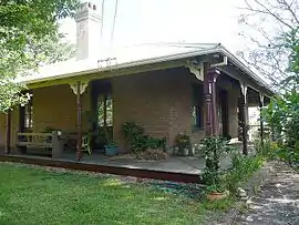 Linden Lodge (1865) | |||||||||||||||
Linden Location in New South Wales | |||||||||||||||
| Coordinates | 33°42′56″S 150°29′46″E | ||||||||||||||
| Population | 501 (2016 census)[1] | ||||||||||||||
| Postcode(s) | 2778 | ||||||||||||||
| LGA(s) | City of Blue Mountains | ||||||||||||||
| State electorate(s) | Blue Mountains | ||||||||||||||
| Federal Division(s) | Macquarie | ||||||||||||||
| |||||||||||||||
Description and history
The railway station at Linden was built in 1874 and was named after Linden Lodge, the home built in 1865 by local businessman William Jolley Henderson.[3] Linden was originally known as Seventeen Mile Hollow because of its location 17 miles (27.35 km) from the Nepean River. It was originally the location of a tollhouse erected in 1849 and demolished in the 1860s during the construction of the railway.
The village is near the grave of John Donohoe, a road-gang convict who died on 25 June 1837.[4] It is also near Caley's Repulse, a mound of rocks in the shape of a pyramid that was believed to have been constructed by Aborigines. However, some sources maintain that this is a fallacy and that the pile of rocks actually date back to 1912, when a group from the Royal Australian Historical Society made a pile of rocks in the wrong place.[5] Other nearby attractions include King's Cave and Linden Observatory.
Linden Creek, which carves a deep valley on the north side of Linden, is a major tributary of the Grose River.
Heritage listings
Linden has a number of heritage-listed sites, including:
- Blue Mountains National Park: Blue Mountains walking tracks[6]
- 91–111 Glossop Road: Linden Observatory Complex[7]
- off Railway Parade: Cox's Road and Early Deviations - Linden, Linden Precinct[8]
Gallery
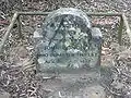 Donohoe's Grave
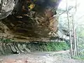 Kings Cave
References
- Australian Bureau of Statistics (27 June 2017). "Linden (NSW) (State Suburb)". 2016 Census QuickStats. Retrieved 24 April 2018.

- Australian Bureau of Statistics (31 October 2012). "Linden (State Suburb)". 2011 Census QuickStats. Retrieved 30 December 2015.
- "Origin of Blue Mountains Town Names" Blue Mountains City Council
- John Low, "The Mystery of Linden's Lonely Gravestone: who was John Donohoe?" pp. 26–33
- How to See the Blue Mountains, Jim Smith (Second Back Row Press) 1986, p.70
- "Blue Mountains Walking tracks". New South Wales State Heritage Register. Office of Environment and Heritage. H00980. Retrieved 18 May 2018.
- "Linden Observatory Complex". New South Wales State Heritage Register. Office of Environment and Heritage. H01807. Retrieved 18 May 2018.
- "Cox's Road and Early Deviations - Linden, Linden Precinct". New South Wales State Heritage Register. Office of Environment and Heritage. H01953. Retrieved 18 May 2018.
