Jenolan River
The Jenolan River, a perennial river that is part of the Hawkesbury-Nepean catchment, is located in the Central Tablelands region of New South Wales, Australia.
| Jenolan Harrys River[1] | |
|---|---|
 | |
| Location | |
| Country | Australia |
| State | New South Wales |
| Region | Sydney Basin (IBRA), Central Tablelands |
| Local government area | Oberon |
| Physical characteristics | |
| Source | Black Mount, Great Dividing Range |
| • location | Oberon |
| • elevation | 1,190 m (3,900 ft) |
| Mouth | confluence with the Coxs River |
• location | below Mount Jenolan |
• elevation | 939 m (3,081 ft) |
| Length | 11 km (6.8 mi) |
| Basin features | |
| River system | Hawkesbury-Nepean catchment |
| Tributaries | |
| • right | Mumbedah Creek |
| Forest | Jenolan State Forest |
| [1][2] | |
Course and features
The Jenolan River rises below Black Mount on the eastern slopes of the Great Dividing Range southeast of Oberon, and flows generally southeast and east, joined by one minor tributary, before reaching its confluence with the Coxs River below Mount Jenolan. The river descends 80 metres (260 ft) over its 11-kilometre (6.8 mi) course.[2]
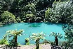
At Jenolan Caves the river flows underground for approximately 400 metres (1,300 ft).[1]
See also
References
- "Jenolan River". Geographical Names Register (GNR) of NSW. Geographical Names Board of New South Wales. Retrieved 3 April 2013.

- "Jenolan River, NSW". Bonzle Digital Atlas of Australia. Retrieved 3 April 2013.
This article is issued from Wikipedia. The text is licensed under Creative Commons - Attribution - Sharealike. Additional terms may apply for the media files.