List of cities in Brandenburg by population
The following list sorts all cities and communes in the German state of Brandenburg with a population of more than 15,000.[1] As of December 31, 2017, 41 cities fulfill this criterion and are listed here. This list refers only to the population of individual municipalities within their defined limits, which does not include other municipalities or suburban areas within urban agglomerations.
List
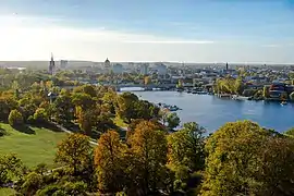
Potsdam
Cottbus
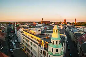
Brandenburg an der Havel
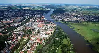
Frankfurt (Oder)
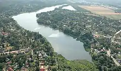
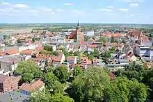
Falkensee
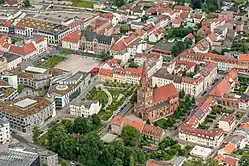
Eberswalde
The following table lists the 41 cities and communes in Brandenburg with a population of at least 15,000 on December 31, 2017, as estimated by the Federal Statistical Office of Germany.[2] A city is displayed in bold if it is a state or federal capital.
- The city rank by population as of December 31, 2017, as estimated by the Federal Statistical Office of German[2]
- The city name[2]
- The name of the district (Landkreis) in which the city lies (some cities are districts on their own called urban districts)[2]
- The city population as of December 31, 2017, as estimated by the Federal Statistical Office of Germany[2]
- The city population as of May 9, 2011, as enumerated by the 2011 European Union census[3]
- The city land area as of December 31, 2017[2]
- The city population density as of December 31, 2017 (residents per unit of land area)[2]
| 2017 Rank |
City | district | 2017 estimate | 2011 Census | 2017 land area | 2017 pop. density |
|---|---|---|---|---|---|---|
| 1 | Potsdam | urban district | 175,710 | 156,021 | 188 km² | 933.3/km² |
| 2 | Cottbus | urban district | 101,036 | 99,984 | 166 km² | 610.0/km² |
| 3 | Brandenburg an der Havel | urban district | 71,886 | 71,569 | 230 km² | 312.9/km² |
| 4 | Frankfurt (Oder) | urban district | 58,237 | 59,140 | 148 km² | 393.9/km² |
| 5 | Oranienburg | Oberhavel | 43,982 | 41,269 | 164 km² | 268.7/km² |
| 6 | Falkensee | Havelland (district) | 43,552 | 40,228 | 43.3 km² | 1,007/km² |
| 7 | Eberswalde | Barnim | 40,223 | 39,166 | 93.6 km² | 429.5/km² |
| 8 | Bernau bei Berlin | Barnim | 38,194 | 35,631 | 104 km² | 366.7/km² |
| 9 | Königs Wusterhausen | Dahme-Spreewald | 36,706 | 33,706 | 96.0 km² | 382.2/km² |
| 10 | Fürstenwalde | Oder-Spree | 32,098 | 30,913 | 70.7 km² | 454.1/km² |
| 11 | Neuruppin | Ostprignitz-Ruppin | 30,889 | 30,328 | 305 km² | 101.2/km² |
| 12 | Schwedt | Uckermark (district) | 30,075 | 31,785 | 206 km² | 146.3/km² |
| 13 | Blankenfelde-Mahlow | Teltow-Fläming | 27,378 | 25,503 | 55.2 km² | 496.2/km² |
| 14 | Strausberg | Märkisch-Oderland | 26,522 | 25,591 | 68.0 km² | 390.3/km² |
| 15 | Hennigsdorf | Oberhavel | 26,369 | 25,520 | 31.5 km² | 837.9/km² |
| 16 | Hohen Neuendorf | Oberhavel | 26,001 | 24,459 | 48.6 km² | 535.4/km² |
| 17 | Teltow | Potsdam-Mittelmark | 25,761 | 22,356 | 21.6 km² | 1,193/km² |
| 18 | Werder (Havel) | Potsdam-Mittelmark | 25,695 | 23,196 | 117 km² | 219.5/km² |
| 19 | Ludwigsfelde | Teltow-Fläming | 25,665 | 23,661 | 110 km² | 233.4/km² |
| 20 | Eisenhüttenstadt | Oder-Spree | 25,057 | 28,219 | 63.5 km² | 394.8/km² |
| 21 | Senftenberg | Oberspreewald-Lausitz | 24,558 | 25,582 | 128 km² | 192.5/km² |
| 22 | Rathenow | Havelland (district) | 24,309 | 24,462 | 113 km² | 214.9/km² |
| 23 | Wandlitz | Barnim | 22,585 | 20,615 | 163 km² | 138.7/km² |
| 24 | Spremberg | Spree-Neiße | 22,456 | 23,615 | 202 km² | 111.0/km² |
| 25 | Luckenwalde | Teltow-Fläming | 20,674 | 20,242 | 46.6 km² | 443.6/km² |
| 26 | Kleinmachnow | Potsdam-Mittelmark | 20,608 | 19,874 | 11.9 km² | 1,730/km² |
| 27 | Panketal | Barnim | 20,390 | 18,886 | 25.9 km² | 788.8/km² |
| 28 | Prenzlau | Uckermark (district) | 19,110 | 19,296 | 143 km² | 133.7/km² |
| 29 | Zossen | Teltow-Fläming | 18,915 | 17,267 | 180 km² | 104.9/km² |
| 30 | Forst (Lausitz) | Spree-Neiße | 18,353 | 19,757 | 111 km² | 165.8/km² |
| 31 | Neuenhagen bei Berlin | Märkisch-Oderland | 17,986 | 16,751 | 19.6 km² | 917.2/km² |
| 32 | Hoppegarten | Märkisch-Oderland | 17,966 | 16,628 | 32.0 km² | 561.8/km² |
| 33 | Nauen | Havelland (district) | 17,686 | 16,385 | 268 km² | 66.0/km² |
| 34 | Wittenberge | Prignitz | 17,201 | 17,792 | 50.6 km² | 339.7/km² |
| 35 | Guben | Spree-Neiße | 17,174 | 18,620 | 44.0 km² | 390.4/km² |
| 36 | Finsterwalde | Elbe-Elster | 16,409 | 16,970 | 77.2 km² | 212.5/km² |
| 37 | Lübbenau | Oberspreewald-Lausitz | 16,090 | 16,489 | 139 km² | 115.4/km² |
| 38 | Templin | Uckermark (district) | 15,974 | 16,237 | 379 km² | 42.1/km² |
| 39 | Rüdersdorf bei Berlin | Märkisch-Oderland | 15,569 | 14,922 | 70.4 km² | 221.2/km² |
| 40 | Stahnsdorf | Potsdam-Mittelmark | 15,270 | 14,031 | 49.5 km² | 308.7/km² |
| 41 | Petershagen-Eggersdorf | Märkisch-Oderland | 15,049 | 13,890 | 17.6 km² | 853.6/km² |
External links
References
- "Laufende Stadtbeobachtung – Raumabgrenzungen" (in German). Bundesinstitut für Bau-, Stadt- und Raumforschung. Archived from the original on October 1, 2017. Retrieved Feb 15, 2018.
- "Homepage - Federal Statistical Office (Destatis)". www.destatis.de.
- "Bevölkerung nach Geschlecht für Kreise und kreisfreie Städte" (XLS) (in German). Wiesbaden: Federal Statistical Office of Germany. April 10, 2014.
| States |  | |
|---|---|---|
| City-states | ||
This article is issued from Wikipedia. The text is licensed under Creative Commons - Attribution - Sharealike. Additional terms may apply for the media files.