List of cultural property of national significance in Switzerland: Appenzell Innerrhoden
This list contains all cultural property of national significance (class A) in the canton of Appenzell Innerrhoden from the 2009 Swiss Inventory of Cultural Property of National and Regional Significance. It is sorted by municipality.
The geographic coordinates provided are in the Swiss coordinate system as given in the Inventory.
Appenzell
| KGS No.? |
Picture | Name | Street Address | CH1903 X coordinate | CH1903 Y coordinate | Location |
|---|---|---|---|---|---|---|
| 333 | 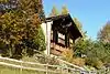 Farm House Kuenzes |
 Lehnstrasse 102 | 749.384 | 245.189 | 47.340625°N 9.415503°E |
| 9907 | 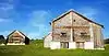 Horersjokelis House with Barn |
 Lehn 76 | 748.971 | 244.987 | 47.338902°N 9.409973°E |
| 342 |  Capuchin Monastery Maria der Engel |
 748.630 | 244.169 | 47.331624°N 9.405191°E | |
| 8813 |  Cantonal Achieves of Appenzell Innerrhoden |
 Marktgasse 2 | 748.976 | 244.127 | 47.331168°N 9.409753°E |
| 9552 | _5563.jpg.webp) Medieval / Early Modern Village |
Medieval / Early Modern Village | 748.400 | 244.000 | 47.330156°N 9.402093°E | |
| 8468 |  Museum Appenzell |
 Hauptgasse 4 | 748.981 | 244.094 | 47.33087°N 9.409808°E |
| 331 | 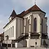 Parish Church of St. Mauritius |
 Hauptgasse 2 | 749.010 | 244.100 | 47.330918°N 9.410194°E |
| 332 | 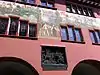 Rathaus (Town council house) |
 Hauptgasse 6 | 748.968 | 244.092 | 47.330855°N 9.409636°E |
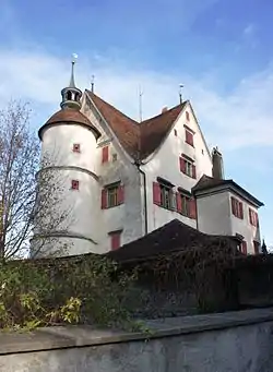
| 354 | Appenzell Castle | Poststrasse 5 | 748.969 | 243.991 | 47.329947°N 9.409615°E | |
| Unknown | ISOS Kleinstadt / Flecken: Appenzell |
Gonten
| KGS No.? |
Picture | Name | Street Address | CH1903 X coordinate | CH1903 Y coordinate | Location |
|---|---|---|---|---|---|---|
| 363 | 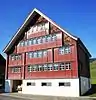 Bürgerhaus Roothuus |
 Dorf | 744.254 | 243.752 | 47.328846°N 9.347179°E |
Rüte
| KGS No.? |
Picture | Name | Street Address | CH1903 X coordinate | CH1903 Y coordinate | Location |
|---|---|---|---|---|---|---|
| 370 | 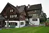 Alte Bleiche |
 Bleichestrasse 8 | 749.623 | 243.824 | 47.328297°N 9.418209°E |
| Unknown | Altwasser-Höhle, Late Paleolithic Shelter |
|||||
| 371 |  Farm House |
 Blumenau | 750.492 | 242.917 | 47.319944°N 9.429397°E |
Schlatt-Haslen
| KGS No.? |
Picture | Name | Street Address | CH1903 X coordinate | CH1903 Y coordinate | Location |
|---|---|---|---|---|---|---|
| 383 | 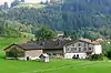 Farm House Ulrichlis |
 Lank | 747.904 | 246.034 | 47.348556°N 9.396204°E |
| Unknown | ISOS hamlet: Schlatt |
Schwende
| KGS No.? |
Picture | Name | Street Address | CH1903 X coordinate | CH1903 Y coordinate | Location |
|---|---|---|---|---|---|---|
| 386 | 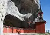 Wildkirchli site with Chapel of St. Michael and Paleolithic Houses / Early Modern Settlement |
749.506 | 238.960 | 47.284588°N 9.415041°E |
References
- All entries, addresses and coordinates are from: "Kantonsliste A-Objekte". KGS Inventar (in German). Federal Office of Civil Protection. 2009. Archived from the original on 28 June 2010. Retrieved 25 April 2011.
External links
- Swiss Inventory of Cultural Property of National and Regional Significance, 2009 edition:
- "Revision of the PCP Inventory (Revision des KGS-Inventars)". KGS Forum. Federal Office of Civil Protection (13/2008). 2008. Archived from the original on 2011-05-05. Retrieved 2011-04-25.
| Wikimedia Commons has media related to Cultural properties of national significance in the canton of Appenzell Innerrhoden. |
This article is issued from Wikipedia. The text is licensed under Creative Commons - Attribution - Sharealike. Additional terms may apply for the media files.