List of cultural property of national significance in Switzerland: Basel-Landschaft
This list contains all cultural property of national significance (class A) in the canton of Basel-Landschaft from the 2009 Swiss Inventory of Cultural Property of National and Regional Significance. It is sorted by municipality and contains 36 individual buildings, 6 collections and 22 archaeological finds.
The geographic coordinates provided are in the Swiss coordinate system as given in the Inventory.
Aesch
| KGS No.? |
Picture | Name | Street Address | CH1903 X coordinate | CH1903 Y coordinate | Location |
|---|---|---|---|---|---|---|
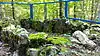
| 1371 | Gmeiniwald (Neolithic Dolmen Grave) | 609.830 | 257.520 | 47.468381°N 7.56902°E | ||
| 9014 | 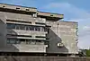 School Complex of Neumatt |
 Sekandarschulhaus | 611.715 | 258.024 | 47.472883°N 7.594035°E |
Allschwil
| KGS No.? |
Picture | Name | Street Address | CH1903 X coordinate | CH1903 Y coordinate | Location |
|---|---|---|---|---|---|---|
| Unknown | ISOS Village: Allschwil |
Anwil
| KGS No.? |
Picture | Name | Street Address | CH1903 X coordinate | CH1903 Y coordinate | Location |
|---|---|---|---|---|---|---|
| Unknown | ISOS Village: Anwil |
Arisdorf
| KGS No.? |
Picture | Name | Street Address | CH1903 X coordinate | CH1903 Y coordinate | Location |
|---|---|---|---|---|---|---|
| Unknown | ISOS Village: Arisdorf |
Arlesheim
| KGS No.? |
Picture | Name | Street Address | CH1903 X coordinate | CH1903 Y coordinate | Location |
|---|---|---|---|---|---|---|
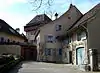
| 1386 | 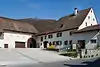 Andlauerhof |
 Andlauerweg 15 | 613.885 | 260.326 | 47.493545°N 7.622891°E |
| 1385 |  Domherrenhaus |
 Domstrasse 2 | 613.547 | 260.265 | 47.493003°N 7.618404°E |
| 1388 | 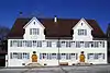 Domherrenhäuser am Domplatz |
 Domplatz 5 –12 | 613.697 | 260.159 | 47.492047°N 7.620391°E |
| 1383 | 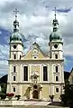 Domkirche (Cathedral Church) |
 Domplatz 16 | 613.730 | 260.160 | 47.492055°N 7.620829°E |
| 1384 9565 |
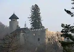 Hermitage with ruins of Birseck Castle as well as Paleolithic Cave Dwellings, an early Cult site and Neolithic graves |
614.210 | 260.100 | 47.491505°N 7.627197°E | |
| 9927 | Reichenstein Castle | 614.345 | 260.685 | 47.496764°N 7.629007°E | ||
| Unknown | ISOS Village: Arlesheim |
Augst
| KGS No.? |
Picture | Name | Street Address | CH1903 X coordinate | CH1903 Y coordinate | Location |
|---|---|---|---|---|---|---|
| 1391 8469 |
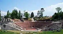 Augusta Raurica (Roman City and Museum) |
 621.317 | 264.849 | 47.534025°N 7.721729°E | |
| 1393 | 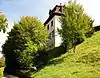 Villa Clavel auf Castelen |
 Giebenacherstrasse 9 | 621.280 | 264.900 | 47.534485°N 7.72124°E |
| Unknown | ISOS Spezialfall: Augst with Augusta Raurica |
Bennwil
| KGS No.? |
Picture | Name | Street Address | CH1903 X coordinate | CH1903 Y coordinate | Location |
|---|---|---|---|---|---|---|
| 9566 | Ötschberg (a Neolithic Settlement) | 625.050 | 251.300 | 47.412035°N 7.770543°E | ||
| Unknown | ISOS Village: Bennwil |
Birsfelden
| KGS No.? |
Picture | Name | Street Address | CH1903 X coordinate | CH1903 Y coordinate | Location |
|---|---|---|---|---|---|---|
| 1401 | 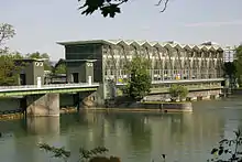 Powerplant Birsfelden |
 Hofstrasse 80 | 614.131 | 267.684 | 47.559716°N 7.626389°E |
| 9730 | 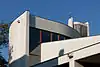 Catholic Church of Bruder Klaus |
 Hardstrasse 28 | 614.089 | 266.785 | 47.551632°N 7.625802°E |
| 11656 | Sternenfeld (Part of the Roman era Rhine fortifications) | 615.100 | 267.350 | 47.556691°N 7.639252°E |
Bottmingen
| KGS No.? |
Picture | Name | Street Address | CH1903 X coordinate | CH1903 Y coordinate | Location |
|---|---|---|---|---|---|---|
| 1403 | 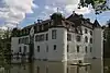 Weiherschloss (Bottmingen Castle) |
 Castlegasse 9 | 609.908 | 263.671 | 47.523701°N 7.570191°E |
Brislach
| KGS No.? |
Picture | Name | Street Address | CH1903 X coordinate | CH1903 Y coordinate | Location |
|---|---|---|---|---|---|---|
| 1406 | Kohlerhöhle (Paleolithic Cave Dwelling) | 609.780 | 253.480 | 47.432046°N 7.568268°E |
Bubendorf
| KGS No.? |
Picture | Name | Street Address | CH1903 X coordinate | CH1903 Y coordinate | Location |
|---|---|---|---|---|---|---|
| 1408 | Wildenstein Castle | 622.422 | 253.303 | 47.430145°N 7.735823°E |
Burg im Leimental
| KGS No.? |
Picture | Name | Street Address | CH1903 X coordinate | CH1903 Y coordinate | Location |
|---|---|---|---|---|---|---|
| 1415 | 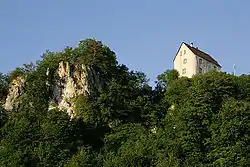 Burg Castle with Chapel |
 600.150 | 256.220 | 47.456762°N 7.440626°E | |
| Unknown | ISOS Village: Burg im Leimental |
Buus
| KGS No.? |
Picture | Name | Street Address | CH1903 X coordinate | CH1903 Y coordinate | Location |
|---|---|---|---|---|---|---|
| 1418 | 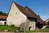 Ständerhaus |
 Rickenbacherstrasse 16 | 632.092 | 261.596 | 47.504331°N 7.864586°E |
| Unknown | ISOS Village: Buus |
Duggingen
| KGS No.? |
Picture | Name | Street Address | CH1903 X coordinate | CH1903 Y coordinate | Location |
|---|---|---|---|---|---|---|
| 1420 | Angenstein Castle | Angenstein 1 | 612.534 | 256.960 | 47.463298°N 7.604869°E | |
| Unknown | ISOS Spezialfall: Angenstein |
Gelterkinden
| KGS No.? |
Picture | Name | Street Address | CH1903 X coordinate | CH1903 Y coordinate | Location |
|---|---|---|---|---|---|---|
| Unknown | ISOS Village: Gelterkinden |
Itingen
| KGS No.? |
Picture | Name | Street Address | CH1903 X coordinate | CH1903 Y coordinate | Location |
|---|---|---|---|---|---|---|
| Unknown | ISOS Village: Itingen |
Kilchberg
| KGS No.? |
Picture | Name | Street Address | CH1903 X coordinate | CH1903 Y coordinate | Location |
|---|---|---|---|---|---|---|
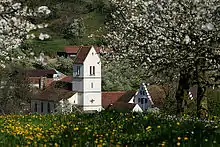
| 1440 | 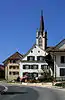 Evangelisch-Reformed Church |
 634.715 | 252.885 | 47.425852°N 7.898722°E | |
| Unknown | ISOS Village: Kilchberg (BL) |
Lampenberg
| KGS No.? |
Picture | Name | Street Address | CH1903 X coordinate | CH1903 Y coordinate | Location |
|---|---|---|---|---|---|---|
| 9567 | Stälzer (Neolithic Flint Tool Production Site | 623.100 | 252.900 | 47.426497°N 7.744789°E |
Langenbruck
| KGS No.? |
Picture | Name | Street Address | CH1903 X coordinate | CH1903 Y coordinate | Location |
|---|---|---|---|---|---|---|
| 9568 | Dürsteltal (Medieval Mine) | 626.000 | 244.800 | 47.353536°N 7.782753°E | ||
| Unknown | ISOS Spezialfall: Schöntal |
Läufelfingen
| KGS No.? |
Picture | Name | Street Address | CH1903 X coordinate | CH1903 Y coordinate | Location |
|---|---|---|---|---|---|---|
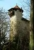
| 1443 | 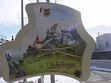 Ruins of Neu-Homburg Castle |
 631.430 | 250.320 | 47.402947°N 7.855006°E |
Laufen
| KGS No.? |
Picture | Name | Street Address | CH1903 X coordinate | CH1903 Y coordinate | Location |
|---|---|---|---|---|---|---|
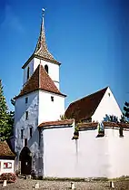
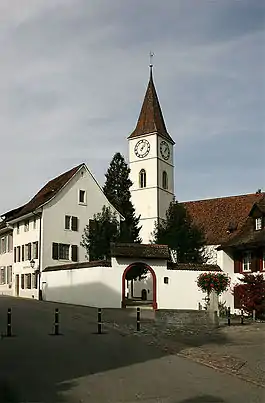
| 1447 | 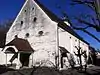 Christian-Catholic Church of St Katharina |
 Amtshausgasse | 604.645 | 252.471 | 47.423027°N 7.500195°E |
| Unknown | 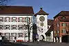 ISOS Kleinstadt / Flecken: Laufen |
Lausen
| KGS No.? |
Picture | Name | Street Address | CH1903 X coordinate | CH1903 Y coordinate | Location |
|---|---|---|---|---|---|---|
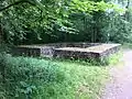
| 1451 | 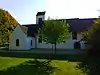 Bettenach (Roman era through High Middle Ages Settlement) |
 624.070 | 258.500 | 47.476828°N 7.757946°E | |
| Unknown | ISOS Spezialfall: Lausen |
Liesberg
| KGS No.? |
Picture | Name | Street Address | CH1903 X coordinate | CH1903 Y coordinate | Location |
|---|---|---|---|---|---|---|
| Unknown | ISOS Spezialfall: Liesbergmüli |
Liestal
| KGS No.? |
Picture | Name | Street Address | CH1903 X coordinate | CH1903 Y coordinate | Location |
|---|---|---|---|---|---|---|
| Unknown | Depot der Archäologie Baselland | Frenkendörferstrasse 15 a | ||||
| 9071 | 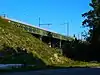 Frenkenbrücke der SCB |
 Frenkenstrasse | 622.943 | 258.608 | 47.47784°N 7.743001°E |
| 1464 |  Munzach (Roman Farmhouse) |
 621.220 | 259.800 | 47.488618°N 7.720201°E | |
| 9569 | Roman Aqueduct | 623.650 | 258.600 | 47.477743°N 7.75238°E | ||
| 8781 |  Cantonal Archive of Basel-Landschaft |
 Wiedenhuberstrasse 35 | 621.694 | 259.631 | 47.487083°N 7.726482°E |
| Unknown | ISOS Kleinstadt / Flecken: Liestal |
Maisprach
| KGS No.? |
Picture | Name | Street Address | CH1903 X coordinate | CH1903 Y coordinate | Location |
|---|---|---|---|---|---|---|
| 1473 | Mill | Unterdorf 16 | 630.770 | 263.651 | 47.522876°N 7.847182°E | |
| Unknown | ISOS Village: Maisprach |
Münchenstein
| KGS No.? |
Picture | Name | Street Address | CH1903 X coordinate | CH1903 Y coordinate | Location |
|---|---|---|---|---|---|---|
| Unknown | 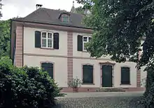 Bruckgut |
 Hauptstrasse 1 | 613.637 | 263.024 | 47.517816°N 7.619683°E |
| 8501 | Foundation Herzog | Oslo-Strasse 8 | 612.884 | 264.752 | 47.533372°N 7.609736°E | |
| 9033 | 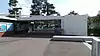 Gartenbad St Jakob |
 Grosse Allee 1 a – h | 613.704 | 265.482 | 47.539921°N 7.620648°E |
| 8620 | 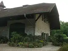 Kutschenmuseum (Carriage Museum) |
 Vorder Brüglingen 4 | 613.252 | 265.168 | 47.537106°N 7.614635°E |
| 8594 | 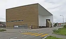 Schaulager |
 Ruchfeldstrasse 19 | 612.951 | 264.205 | 47.528451°N 7.61061°E |
| Unknown | 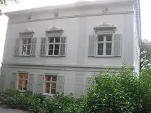 Villa Merian (Business and Park) |
 Unter Brüglingen 1 – 4 | 613.160 | 264.946 | 47.535111°N 7.613407°E |
| Unknown | ISOS Spezialfall: Brüglingen |
Muttenz
| KGS No.? |
Picture | Name | Street Address | CH1903 X coordinate | CH1903 Y coordinate | Location |
|---|---|---|---|---|---|---|
| 11676 | Au-Hard (Part of the late-Roman era Rhine fortifications) | 616.540 | 265.480 | 47.539838°N 7.658314°E | ||
| 1483 | 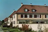 Genossenschaftssiedlung Freidorf |
 St Jakobsstrasse | 614.300 | 265.150 | 47.536922°N 7.628553°E |
| 1485 | 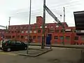 Rangierbahnhof (Train Station) |
 Hauptdienstgebäude | 615.727 | 264.846 | 47.534156°N 7.647494°E |
| 1484 | Reformed Parish Fortified Church of St. Arbogast | Kirchplatz 1 | 615.583 | 263.528 | 47.522305°N 7.645535°E | |
| Unknown | ISOS Village: Muttenz | |||||
| Unknown | ISOS Spezialfall: Siedlung Freidorf |
Nenzlingen
| KGS No.? |
Picture | Name | Street Address | CH1903 X coordinate | CH1903 Y coordinate | Location |
|---|---|---|---|---|---|---|
| 9570 | Birsmatten-Basisgrotte (Mesolithic Settlement with Burial Sites) | 608.390 | 254.880 | 47.444657°N 7.54987°E |
Oltingen
| KGS No.? |
Picture | Name | Street Address | CH1903 X coordinate | CH1903 Y coordinate | Location |
|---|---|---|---|---|---|---|
| 1494 | Reformed Parish Church of St Niklaus | Herrengasse 39 | 637.361 | 253.705 | 47.433082°N 7.933858°E | |
| 9528 | House (known as Grosses Haus) | Hauptstrasse 54 | 637.486 | 253.597 | 47.432104°N 7.935506°E | |
| Unknown | ISOS Village: Oltingen |
Ormalingen
| KGS No.? |
Picture | Name | Street Address | CH1903 X coordinate | CH1903 Y coordinate | Location |
|---|---|---|---|---|---|---|
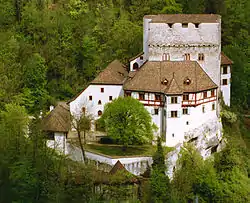
| 1495 | 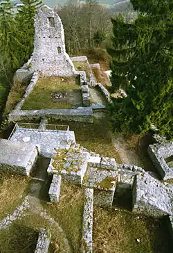 Ruins of Farnsburg Castle |
 632.550 | 260.360 | 47.493192°N 7.870574°E |
Pfeffingen
| KGS No.? |
Picture | Name | Street Address | CH1903 X coordinate | CH1903 Y coordinate | Location |
|---|---|---|---|---|---|---|
| 1499 | 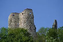 |
Castle Ruins (Pfeffingen, Engenstein, Münchsberg and Schalberg) | 611.560 | 255.850 | 47.453333°N 7.591922°E |
Pratteln
| KGS No.? |
Picture | Name | Street Address | CH1903 X coordinate | CH1903 Y coordinate | Location |
|---|---|---|---|---|---|---|
| Unknown | ISOS Village: Pratteln |
Reigoldswil
| KGS No.? |
Picture | Name | Street Address | CH1903 X coordinate | CH1903 Y coordinate | Location |
|---|---|---|---|---|---|---|
| 9140 | House Preiswerk | Gorisen 231 A | 618.955 | 251.025 | 47.409765°N 7.689775°E |
Rothenfluh
| KGS No.? |
Picture | Name | Street Address | CH1903 X coordinate | CH1903 Y coordinate | Location |
|---|---|---|---|---|---|---|
| Unknown | ISOS Village: Rothenfluh |
Rümlingen
| KGS No.? |
Picture | Name | Street Address | CH1903 X coordinate | CH1903 Y coordinate | Location |
|---|---|---|---|---|---|---|
| 1520 | 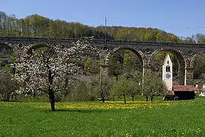 Eisenbahnviadukt (Railroad Bridge) |
 631.070 | 252.680 | 47.42419°N 7.850401°E | |
| Unknown | ISOS Village: Rümlingen |
Sissach
| KGS No.? |
Picture | Name | Street Address | CH1903 X coordinate | CH1903 Y coordinate | Location |
|---|---|---|---|---|---|---|
| 1525 | 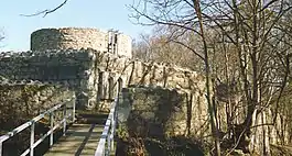 Bischofstein (Prehistoric Hilltop Settlement / Medieval Castle) |
 629.280 | 258.280 | 47.474638°N 7.827046°E | |
| 9591 | Burgenrain (Prehistoric Hilltop Settlement) | 628.620 | 256.420 | 47.457939°N 7.818172°E | ||
| 1523 | 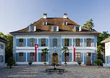 Landsitz Ebenrain |
 Itingerstrasse 13 – 17 | 627.621 | 257.102 | 47.464115°N 7.804966°E |
| 1524 | Reformed Parish Church of St Jakob | Schulstrasse 8 | 627.981 | 257.287 | 47.465764°N 7.809752°E | |
| 1529 |  Sissacherfluh (Prehistoric Hilltop Settlement / Medieval Fortification) |
 628.600 | 258.920 | 47.480424°N 7.818067°E | |
| Unknown | ISOS Verstädtertes Village: Sissach |
Waldenburg
| KGS No.? |
Picture | Name | Street Address | CH1903 X coordinate | CH1903 Y coordinate | Location |
|---|---|---|---|---|---|---|
| 1535 | Gerstelfluh (Prehistoric Hill Settlement / Medieval Government Center) | 624.600 | 247.760 | 47.380213°N 7.764386°E | ||
| 9130 | Villa Gedeon Thommen with Park | Wilweg 8 | 623.337 | 248.411 | 47.386114°N 7.747696°E | |
| Unknown | 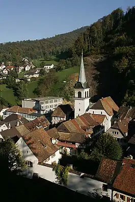 ISOS Kleinstadt / Flecken: Waldenburg |
Wenslingen
| KGS No.? |
Picture | Name | Street Address | CH1903 X coordinate | CH1903 Y coordinate | Location |
|---|---|---|---|---|---|---|
| Unknown | ISOS Village: Wenslingen |
Wintersingen
| KGS No.? |
Picture | Name | Street Address | CH1903 X coordinate | CH1903 Y coordinate | Location |
|---|---|---|---|---|---|---|
| Unknown | ISOS Village: Wintersingen |
Ziefen
| KGS No.? |
Picture | Name | Street Address | CH1903 X coordinate | CH1903 Y coordinate | Location |
|---|---|---|---|---|---|---|
| 9763 | House with Heimposamenterei | Dorf | 620.354 | 253.327 | 47.430428°N 7.708415°E | |
| Unknown | ISOS Village: Ziefen |
Zwingen
| KGS No.? |
Picture | Name | Street Address | CH1903 X coordinate | CH1903 Y coordinate | Location |
|---|---|---|---|---|---|---|
| Unknown | ISOS Village: Zwingen |
Zunzgen
| KGS No.? |
Picture | Name | Street Address | CH1903 X coordinate | CH1903 Y coordinate | Location |
|---|---|---|---|---|---|---|
| 1545 | 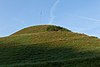 Zunzger Büchel Prehistoric Fortified Hill |
627.790 | 255.170 | 47.446732°N 7.807087°E |
References
- All entries, addresses and coordinates are from: "Kantonsliste A-Objekte". KGS Inventar (in German). Federal Office of Civil Protection. 2009. Archived from the original on 28 June 2010. Retrieved 25 April 2011.
External links
- Swiss Inventory of Cultural Property of National and Regional Significance, 2009 edition:
- "Revision of the PCP Inventory (Revision des KGS-Inventars)". KGS Forum. Federal Office of Civil Protection (13/2008). 2008. Archived from the original on 2011-05-05. Retrieved 2011-04-25.
| Wikimedia Commons has media related to Cultural properties of national significance in the canton of Basel-Landschaft. |
This article is issued from Wikipedia. The text is licensed under Creative Commons - Attribution - Sharealike. Additional terms may apply for the media files.