List of lighthouses in Ohio
This is a list of all lighthouses in the U.S. state of Ohio.
"Historic Light Station Information and Photography: Ohio". United States Coast Guard Historian's Office. Archived from the original on 2017-05-01.
| Name | Image | Location | Coordinates | Year first lit | Automated | Year deactivated | Current Lens | Focal Height |
|---|---|---|---|---|---|---|---|---|
| Ashtabula Harbor Light | 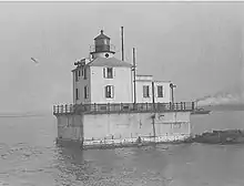 |
Ashtabula | 41.9186°N 80.7959°W | 1905 | 1973 | Active (Also a museum) |
Optic | 51 ft (16 m) |
| Cedar Point Light | 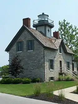 |
Sandusky (Cedar Point) |
41.488220°N 82.693441°W | 1839 (Former) 1862 (Current) |
Never | 1975 | Unknown | Unknown |
| Conneaut West Breakwater Lighthouse |  |
Conneaut | N/A | 1936 | 1972 | Active | 375mm | Unknown |
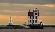
| Fairport Harbor West Breakwater Light (Originally: West Pierhead) |
 |
Fairport Harbor | 41°46′4.30″N 81°16′52.25″W | 1911 (Former) 1925 (Current) |
Unknown | Active (Also a private home) |
Unknown | 56 ft (17 m) |
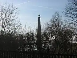
| Fairport Harbor East Pierhead Light | Fairport Harbor | N/A | 1875[1] | Never | 1911[1] (Removed) |
None | Unknown | |
| Grand Lake St. Marys Lighthouse (aka: Northwood Light) |
 |
Celina | 40°32′36″N 84°28′53″W | 1923 | 1982 | Active | Unknown | 135 ft (41 m) |
| Grand River (Fairport Harbor) Light | 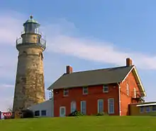 |
Fairport Harbor | 41°45′25.07″N 81°16′38.33″W | 1825 (Former) 1871 (Current) |
Never | 1925 | None | Unknown |
| Green Island Light | .jpg.webp) |
Put-in-Bay Township (Green Island) |
41.6455°N 82.8675°W | 1855 (Former) 1864 (Current) |
1926 | 1939 (Now in ruins) |
None | Unknown |
| Huron Harbor Light | 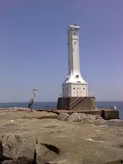 |
Huron | 41°24′16.59″N 82°32′37.65″W | 1835 (Former) 1936 (Current) |
1972 (Fully) |
Active | 375mm | 80 ft (24 m) |
| Lorain West Breakwater Light (aka: Lorain Harbor Light) |
 |
Lorain | 41°28′39.28″N 82°11′25.90″W | 1836 (Former) 1917 (Current) |
Never | 1966 | None | Unknown |
| Manhattan Range Front Light (aka: Manhattan Range Lights) |
Toledo | N/A | 1895[2] (Former) 1918[2](Current) |
Unknown | Active[2] | Unknown | 40 ft (12 m)[2] | |
| Manhattan Rear Range Light (aka: Manhattan Range Lights) |
Toledo | N/A | 1895[2] (Former) 1918[2] (Current) |
Unknown | Active[2] | Unknown | 86 ft (26 m)[2] | |
| Marblehead Light | 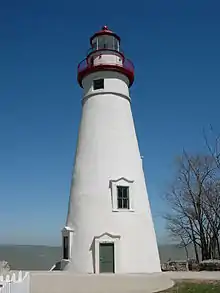 |
Marblehead | 41°32′11.2″N 82°42′42.2″W | 1821 | 1958 | Active | 300mm | 60 ft (18 m) |
| Port Clinton Light | 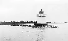 |
Port Clinton | 41.5150°N 82.9344°W | 1833 (Former) 1896 (Current) |
1926 | Active | Fifth order Fresnel lens (Replica[3]) |
26 ft (7.9 m) |
| Sandusky Pierhead Light | Sandusky | N/A | 1925 (Former) 1990s (Current) |
Always | Active | Unknown | 66 ft (20 m) (Former) | |
| South Bass Island Light |  |
Put-in-Bay Township (South Bass Island) |
41.6290°N 82.8415°W | 1897 | Never | 1962 | None | Unknown |
| Toledo Harbor Light | 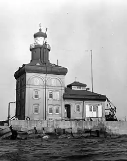 |
Jerusalem Township | 41°45′42″N 83°19′42″W | 1904 | 1965 | Active | 300mm | 72 ft (22 m) |
| Turtle Island Light | Toledo[4] (Turtle Island) |
41°45′09″N 83°23′28″W (Island Coordinates) |
1831 (Former) 1866 (Current) |
Never | 1904 (Now Ruins) |
None | Unknown | |
| Vermilion Light | 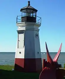 |
Vermilion | 41°25′28.8″N 82°21′59.7″W | 1847 (Former) 1877 (Current) 1991 (Replica) |
1920 | 1929 (Dismantled) |
Fifth order Fresnel lens (Replica) |
Unknown |
| West Sister Island Light | 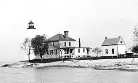 |
Jerusalem Township | 41°44′23″N 83°6′19″W (Island Coordinates) |
1848 | 1937 | Active | Unknown | Unknown |
References
- "Fairport Harbor West Breakwater Lighthouse". Lighthouse Friends. Retrieved September 21, 2017.
- "Manhattan Range, OH". Lighthouse Friends. Retrieved September 28, 2017.
- "Port Clinton Light". Lighthouse Friends. Retrieved September 27, 2017.
- Archinger, Warren (December 20, 2004). "Ohio Lighthouses—Turtle Island Light, Maumee Bay—Lake Erie". Mudjaw Systems. Archived from the original on May 27, 2008. Retrieved March 20, 2010.
This article is issued from Wikipedia. The text is licensed under Creative Commons - Attribution - Sharealike. Additional terms may apply for the media files.