List of listed buildings in Annan, Dumfries and Galloway
This is a list of listed buildings in the parish of Annan in Dumfries and Galloway, Scotland.
| Wikimedia Commons has media related to Annan, Dumfries and Galloway. |
List
| Name | Location | Date Listed | Grid Ref. [note 1] | Geo-coordinates | Notes | LB Number [note 2] | Image |
|---|---|---|---|---|---|---|---|
| 74-78 (Even Nos) High Street | 54°59′15″N 3°15′44″W | Category B | 21103 | 
| |||
| 18 Scott Street, former Stables, (now Property of Seaforth Cottage) | 54°59′12″N 3°15′15″W | Category C(S) | 21121 |
| |||
| Solway Street, Seaforth House and Gatepiers and Railings | 54°59′08″N 3°15′16″W | Category B | 21124 |
| |||
| Standalane, Newington House | 54°59′26″N 3°15′13″W | Category C(S) | 21125 |
| |||
| 3-11 (Odd Nos) Bank Street | 54°59′13″N 3°15′44″W | Category C(S) | 21063 |
| |||
| Church Street, 1-12 (inclusive Nos) Cumberland Terrace, 4 Solway Street, including Boundary Walls and Gatepiers | 54°59′12″N 3°15′25″W | Category B | 21077 |
| |||
| Greencroft Wynd Dovecot | 54°59′11″N 3°15′47″W | Category C(S) | 21083 |
| |||
| Blacketlees Farmhouse and Steading | 55°00′21″N 3°16′08″W | Category B | 3488 |
| |||
| Diamond Jubilee Bridge | 55°00′21″N 3°15′56″W | Category B | 3506 | .jpg.webp)
| |||
| Hayknowes former Bacon Factory (on East Side of Road) | 54°58′39″N 3°17′32″W | Category B | 3509 |
| |||
| Mount Annan Stables | 55°00′54″N 3°15′21″W | Category C(S) | 3516 |
| |||
| Warmanbie Cottage | 55°00′27″N 3°15′25″W | Category B | 3482 |
| |||
| 18-26 (Even Nos) Port Street including Low Wing adjoining at South | 54°59′11″N 3°15′56″W | Category C(S) | 50179 |
| |||
| 73 And 75 High Street | 54°59′14″N 3°15′43″W | Category B | 21092 |
| |||
| 66, 68 High Street | 54°59′15″N 3°15′45″W | Category C(S) | 21102 |
| |||
| 19 Bank Street, Post Office | 54°59′11″N 3°15′44″W | Category B | 21065 |
| |||
| Bank Street, Former Library and Public Hall | 54°59′12″N 3°15′42″W | Category B | 21068 |
| |||
| 12 Downie's Wynd, Market Hall | 54°59′13″N 3°15′41″W | Category B | 21079 |
| |||
| 5, 7, 9 High Street ("Old Academy") | 54°59′13″N 3°15′54″W | Category A | 21086 | .jpg.webp)
| |||
| Beckfoot Farmhouse with Steading and Gatepiers | 54°58′46″N 3°13′29″W | Category B | 3487 |
| |||
| Distillery Farm, Z-Plan Former Distillery Range and Tall Chimney Stack | 55°00′08″N 3°15′38″W | Category B | 3507 |
| |||
| Milnfield Cottage | 54°59′07″N 3°16′23″W | Category C(S) | 3514 |
| |||
| Preston Hall Farmhouse | 55°00′05″N 3°13′52″W | Category C(S) | 3479 |
| |||
| 121 High Street, Argyle House | 54°59′14″N 3°15′33″W | Category B | 50032 |
| |||
| High Street, Dovecot to Rear of Queensberry Arms | 54°59′12″N 3°15′46″W | Category B | 21090 |
| |||
| 2-10 (Even Nos) High Street, Blue Bell Inn including former Stables Court | 54°59′14″N 3°15′54″W | Category B | 21096 | 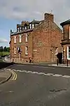
| |||
| Port Street, Braehouse | 54°59′07″N 3°16′04″W | Category B | 21112 |
| |||
| 28 Port Street, Scaurbank and Gatepiers and Boundary Walls | 54°59′10″N 3°15′59″W | Category C(S) | 21116 |
| |||
| Station Road, Annan Academy | 54°59′05″N 3°15′36″W | Category B | 21126 | 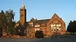
| |||
| Station Road Annan Station | 54°59′01″N 3°15′44″W | Category B | 21127 |
| |||
| 2, 4 Battery Street | 54°59′14″N 3°15′53″W | Category B | 21071 |
| |||
| 2, 4, 6 Carlyle Place | 54°59′10″N 3°15′54″W | Category B | 21075 |
| |||
| Bonshaw Lodge and Gatepiers | 55°02′31″N 3°11′39″W | Category C(S) | 3492 |
| |||
| Brydekirk Mains Farmhouse and Steading including St Bride's Tower | 55°01′41″N 3°16′28″W | Category C(S) | 3493 |
| |||
| Hayknowes Farmhouse And Steading | 54°58′39″N 3°17′34″W | Category C(S) | 3508 |
| |||
| Newbie Walled Garden | 54°58′14″N 3°17′28″W | Category B | 3475 |
| |||
| Watchill House | 54°59′06″N 3°14′47″W | Category C(S) | 3484 |
| |||
| Bruce Street and North Street, Greenbank with Lodge, Gates and Gatepiers | 54°59′25″N 3°15′49″W | Category C(S) | 48277 |
| |||
| 83, 85, 87 High Street | 54°59′14″N 3°15′40″W | Category C(S) | 21094 |
| |||
| 64 High Street | 54°59′15″N 3°15′45″W | Category C(S) | 21101 |
| |||
| 80 High Street | 54°59′15″N 3°15′42″W | Category B | 21104 |
| |||
| 75-87 (Odd Nos) Port Street and Welldale Mill adjoining | 54°58′57″N 3°16′13″W | Category B | 21113 |
| |||
| Station Road: Central Hotel | 54°59′05″N 3°15′44″W | Category C(S) | 21128 | 
| |||
| Annan Viaduct | 54°59′05″N 3°16′17″W | Category B | 21062 | .jpg.webp)
| |||
| 27, 29 Bank Street and Gatepiers and Railings | 54°59′11″N 3°15′44″W | Category A | 21066 |
| |||
| 35, 37 Butts Street | 54°59′22″N 3°15′37″W | Category C(S) | 21073 |
| |||
| 6 Butts Street including Gatepiers and Vaulted Cellars | 54°59′17″N 3°15′35″W | Category B | 21074 |
| |||
| 11, 13 Church Street | 54°59′13″N 3°15′28″W | Category B | 21076 |
| |||
| 30, 32 Ednam Street | 54°59′10″N 3°15′34″W | Category B | 21082 |
| |||
| Bonshaw Tower and House and Courtyard Walls | 55°02′14″N 3°11′12″W | Category A | 3489 | 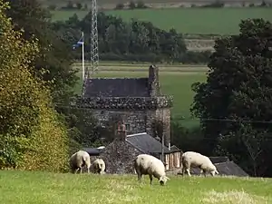
| |||
| Brydekirk Village: Brydekirk Church | 55°01′17″N 3°16′47″W | Category C(S) | 3495 | .jpg.webp)
| |||
| Croftheads Farmhouse and Steading | 54°59′00″N 3°17′46″W | Category C(S) | 3497 |
| |||
| Northfield Farmhouse and Steading | 55°00′07″N 3°15′17″W | Category C(S) | 3477 |
| |||
| High Street: Town Hall and Freestanding Lamps | 54°59′14″N 3°15′52″W | Category B | 21097 | 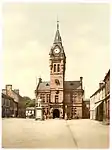
| |||
| High Street: Annan Parish Church and Churchyard Boundary Walls and Gatepiers, (Church of Scotland) | 54°59′15″N 3°15′30″W | Category A | 21106 | .jpg.webp)
| |||
| High Street: Annan Parish Churchyard, Statue to Edward Irving | 54°59′15″N 3°15′30″W | Category B | 21107 | 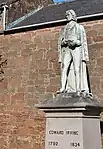
| |||
| Port Street, Viaduct | 54°59′05″N 3°16′17″W | Category B | 21110 |
| |||
| 2, 4 Port Street | 54°59′13″N 3°15′55″W | Category C(S) | 21114 |
| |||
| 20 Scott Street | 54°59′11″N 3°15′14″W | Category B | 21122 |
| |||
| 1 Solway Street | 54°59′12″N 3°15′22″W | Category C(S) | 21123 |
| |||
| 15 Bank Street, Erskine Church, Screen Walls and Gatepiers | 54°59′12″N 3°15′44″W | Category B | 21064 | .jpg.webp)
| |||
| Bank Street, St Andrews Greenknowe Erskine Parish Church (Church Of Scotland) | 54°59′11″N 3°15′42″W | Category B | 21070 | .jpg.webp)
| |||
| 33 Butts Street and 39 English Street | 54°59′22″N 3°15′37″W | Category B | 21072 |
| |||
| 14 Ednam Street | 54°59′10″N 3°15′37″W | Category B | 21081 |
| |||
| 43, 45 High Street | 54°59′13″N 3°15′48″W | Category B | 21087 |
| |||
| Brydekirk Village, Brydekirk Bridge | 55°01′22″N 3°16′26″W | Category A | 3494 | 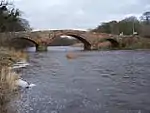
| |||
| Cleuchead Bridge (Over Butcherbeck Burn) | 55°01′16″N 3°15′52″W | Category B | 3496 |
| |||
| Howes Cottage | 54°59′25″N 3°16′20″W | Category B | 3511 |
| |||
| Newbie Mains | 54°58′11″N 3°17′35″W | Category C(S) | 3517 |
| |||
| Warmanbie Lodge and Gatepiers | 55°00′22″N 3°15′16″W | Category B | 3483 |
| |||
| 117, 119 High Street | 54°59′14″N 3°15′35″W | Category B | 21095 |
| |||
| High Street: Annan Old Churchyard, Walls and Gatepiers | 54°59′15″N 3°15′51″W | Category B | 21098 | 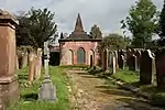
| |||
| Port Street Quays | 54°58′53″N 3°16′15″W | Category B | 21109 |
| |||
| Port Street Warehouse opposite Welldale Mill | 54°58′58″N 3°16′15″W | Category B | 21119 | .jpg.webp)
| |||
| 8, 10 Bank Street | 54°59′12″N 3°15′43″W | Category B | 21069 |
| |||
| Ednam Street, Adult Training Centre (Former Academy) Boundary Wall And Gatepiers | 54°59′11″N 3°15′37″W | Category B | 21080 |
| |||
| Greencroft Wynd, Greencroft House (Crombie's Workshop) | 54°59′10″N 3°15′47″W | Category B | 21084 | .jpg.webp)
| |||
| 1, 3 High Street | 54°59′13″N 3°15′55″W | Category B | 21085 |
| |||
| Howes Farmhouse and Steading | 54°59′27″N 3°16′20″W | Category B | 3510 |
| |||
| Violetbank Cottage | 54°59′35″N 3°16′11″W | Category C(S) | 3480 |
| |||
| 67, 69, 71 High Street and 1 Bank Street | 54°59′14″N 3°15′44″W | Category B | 21091 |
| |||
| 77, 79, 81 High Street | 54°59′14″N 3°15′42″W | Category C(S) | 21093 |
| |||
| Long Meadow | 54°58′54″N 3°15′53″W | Category C(S) | 21108 |
| |||
| 15 Port Street Albert Hall | 54°59′09″N 3°15′56″W | Category B | 21111 | .jpg.webp)
| |||
| St John's Road: St John's Episcopal Church, Gates and Gatepiers | 54°59′08″N 3°15′41″W | Category B | 21120 | .jpg.webp)
| |||
| 6 Wellington Street | 54°59′22″N 3°15′42″W | Category B | 21129 |
| |||
| Annan Bridge (A75 over the River Annan) | 54°59′14″N 3°15′57″W | Category A | 21061 | 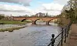
| |||
| 47, 49 High Street, Queensberry Arms Hotel | 54°59′13″N 3°15′47″W | Category B | 21088 | 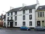
| |||
| Howes Scaur Farmhouse and Steading | 54°59′33″N 3°16′35″W | Category C(S) | 3512 |
| |||
| Hoddom Castle, East Lodge | 55°02′29″N 3°18′40″W | Category B | 3576 | 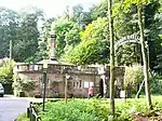
| |||
| North Howes Barn and Former Bacon Factory | 54°59′29″N 3°16′15″W | Category C(S) | 3476 |
| |||
| Fairfield Place, West Side | 54°59′16″N 3°15′46″W | Category C(S) | 50030 |
| |||
| High Street, Summerhouse at rear of Queensberry Hotel | 54°59′11″N 3°15′47″W | Category C(S) | 21089 |
| |||
| 28, 30 High Street, Annan Savings Bank | 54°59′14″N 3°15′50″W | Category B | 21099 |
| |||
| 50, 52 High Street, Royal Bank of Scotland | 54°59′15″N 3°15′48″W | Category C(S) | 21100 |
| |||
| 82 High Street, Buck Inn | 54°59′15″N 3°15′41″W | Category C(S) | 21105 |
| |||
| 2 Bank Street | 54°59′13″N 3°15′43″W | Category B | 21067 |
| |||
| 1 Downie's Wynd | 54°59′13″N 3°15′41″W | Category B | 21078 |
| |||
| Bonshaw Sundial | 55°02′14″N 3°11′13″W | Category B | 3490 |
| |||
| Bonshaw Mill | 55°02′17″N 3°11′13″W | Category B | 3491 |
| |||
| Limekilns Farmhouse | 55°00′42″N 3°17′45″W | Category B | 3513 |
| |||
| Milnfield Farmhouse and Steading | 54°59′05″N 3°16′24″W | Category B | 3515 |
| |||
| Outertown | 55°00′31″N 3°14′51″W | Category B | 3478 |
| |||
| Warmanbie | 55°00′32″N 3°15′37″W | Category B | 3481 |
|
Key
The scheme for classifying buildings in Scotland is:
- Category A: "buildings of national or international importance, either architectural or historic; or fine, little-altered examples of some particular period, style or building type."[1]
- Category B: "buildings of regional or more than local importance; or major examples of some particular period, style or building type, which may have been altered."[1]
- Category C: "buildings of local importance; lesser examples of any period, style, or building type, as originally constructed or moderately altered; and simple traditional buildings which group well with other listed buildings."[1]
In March 2016 there were 47,288 listed buildings in Scotland. Of these, 8% were Category A, and 50% were Category B, with the remaining 42% being Category C.[2]
Notes
- Sometimes known as OSGB36, the grid reference (where provided) is based on the British national grid reference system used by the Ordnance Survey.
• "Guide to National Grid". Ordnance Survey. Retrieved 2007-12-12.
• "Get-a-map". Ordnance Survey. Retrieved 2007-12-17. - Historic Environment Scotland assign a unique alphanumeric identifier to each designated site in Scotland, for listed buildings this always begins with "LB", for example "LB12345".
References
- All entries, addresses and coordinates are based on data from Historic Scotland. This data falls under the Open Government Licence
- "What is Listing?". Historic Environment Scotland. Retrieved 29 May 2018.
- Scotland's Historic Environment Audit 2016 (PDF). Historic Environment Scotland and the Built Environment Forum Scotland. pp. 15–16. Retrieved 29 May 2018.
This article is issued from Wikipedia. The text is licensed under Creative Commons - Attribution - Sharealike. Additional terms may apply for the media files.