List of listed buildings in Moffat, Dumfries and Galloway
This is a list of listed buildings in the civil parish of Moffat in Dumfries and Galloway, Scotland.
List
| Name | Location | Date Listed | Grid Ref. [note 1] | Geo-coordinates | Notes | LB Number [note 2] | Image |
|---|---|---|---|---|---|---|---|
| 20 Well Road Strathview (North Side) | 55°20′01″N 3°26′24″W | Category B | 37943 |  | |||
| Well Road Floral Cottage And Briary Cottage (North Side) | 55°20′05″N 3°26′14″W | Category B | 37946 | | |||
| 11-13 (Odd) Well Street | 55°19′59″N 3°26′35″W | Category C(S) | 37950 | | |||
| 27, 29 Well Street | 55°19′59″N 3°26′33″W | Category C(S) | 37953 | | |||
| Academy Road, St Mary's Uf Church | 55°20′07″N 3°26′42″W | Category B | 37857 | | |||
| Academy Road, Stratford House | 55°20′05″N 3°26′43″W | Category C(S) | 37858 | | |||
| 5 Beechgrove | 55°20′12″N 3°26′48″W | Category C(S) | 37866 | | |||
| Born Side, St John's Episcopal Church | 55°19′57″N 3°26′28″W | Category B | 37879 | | |||
| High Street Raven's Neuk | 55°20′03″N 3°26′43″W | Category C(S) | 37903 | | |||
| High Street, Ram Lodge And Centra | 55°20′01″N 3°26′39″W | Category C(S) | 37907 | | |||
| High Street Bonnington Hotel | 55°19′59″N 3°26′38″W | Category B | 37911 | | |||
| High Street Old Court House | 55°19′58″N 3°26′37″W | Category B | 37912 | | |||
| High Street, Old Parish Churchyard | 55°19′56″N 3°26′33″W | Category C(S) | 37917 | | |||
| 4 High Street The Coachman | 55°19′59″N 3°26′40″W | Category B | 37921 | | |||
| Victoria Place Larch-Hill House | 55°20′08″N 3°26′33″W | Category B | 37937 | | |||
| Well Road, Mill Cottage (South Side) | 55°20′01″N 3°26′17″W | Category C(S) | 37939 | | |||
| Breckonside Tower | 55°18′21″N 3°24′24″W | Category C(S) | 16848 | | |||
| Granton House, Balustrade To South And Gatepiers | 55°22′28″N 3°27′43″W | Category A | 16858 | | |||
| Holehouse Linn Bridge | 55°21′48″N 3°28′41″W | Category B | 16860 | | |||
| Ballplay Road Wellview | 55°20′00″N 3°25′54″W | Category C(S) | 37862 | | |||
| 7 Beechgrove Roseneath | 55°20′13″N 3°26′48″W | Category C(S) | 37868 | | |||
| 9 And 10 (Hillview) Beechgrove | 55°20′14″N 3°26′49″W | Category C(S) | 37870 | | |||
| 14 Beechgrove Rockhill | 55°20′15″N 3°26′51″W | Category C(S) | 37874 | | |||
| 17 Beechgrove Springfield | 55°20′16″N 3°26′52″W | Category C(S) | 37876 | | |||
| Church View, Church Gate | 55°19′55″N 3°26′38″W | Category C(S) | 37885 | | |||
| 7 Church Street | 55°19′58″N 3°26′41″W | Category C(S) | 37888 | | |||
| Eastgate, Limetree House | 55°20′01″N 3°26′35″W | Category B | 37889 | | |||
| High Street Balmoral Hotel (Former Spur Inn) | 55°20′00″N 3°26′39″W | Category B | 37909 | | |||
| High Street Buccleuch Arms | 55°19′57″N 3°26′40″W | Category B | 37922 | | |||
| High Street Annandale Arms Hotel | 55°19′59″N 3°26′41″W | Category B | 37926 | | |||
| Mansfield Place, Proudfoot Institute | 55°19′58″N 3°26′32″W | Category B | 37929 | | |||
| Old Well Road Park Cottage | 55°20′05″N 3°26′29″W | Category B | 37931 | | |||
| School Lane Kirkland House | 55°20′02″N 3°26′27″W | Category B | 37933 | | |||
| Dumcrieff Bridge | 55°18′57″N 3°25′12″W | Category C(S) | 16855 | | |||
| Heatheryhaugh, Garden Bridge | 55°20′30″N 3°25′56″W | Category B | 16862 | | |||
| New Bridge (Formerly A701 Over River Annan) | 55°20′13″N 3°27′11″W | Category C(S) | 16866 | | |||
| Well Road Millbank (North Side) | 55°20′06″N 3°26′06″W | Category C(S) | 37947 | | |||
| Academy Road, 1 Stanley Place, Kirkview And Archbald Moffatt House (Formerly 2 Stanley Place) | 55°20′07″N 3°26′45″W | Category B | 37861 | | |||
| Ballplay Road Dunmore Villa | 55°19′59″N 3°25′53″W | Category B | 37863 | | |||
| Eastgate Summerlea House | 55°20′03″N 3°26′39″W | Category C(S) | 37891 | | |||
| Eastgate St Ninian's Prep School | 55°20′03″N 3°26′32″W | Category C(S) | 37894 | | |||
| Glendyne Hartfell Crescent | 55°20′12″N 3°26′23″W | Category B | 37897 | | |||
| Haywood Road Hunter's Croft | 55°20′08″N 3°26′04″W | Category C(S) | 37898 | | |||
| Haywood Road, Merlewood | 55°20′12″N 3°26′08″W | Category B | 37899 | | |||
| High Street Ivy House | 55°20′02″N 3°26′40″W | Category C(S) | 37905 | | |||
| High Street, Moffat Post Office | 55°20′01″N 3°26′39″W | Category C(S) | 37908 | | |||
| High Street, Spar With 1-5 Well Street | 55°19′58″N 3°26′37″W | Category B | 37913 | | |||
| High Street, The Tartan Gift Shop And 2 Holm Street | 55°19′56″N 3°26′37″W | Category C(S) | 37918 | | |||
| Archbank Bridge | 55°20′48″N 3°25′57″W | Category B | 16846 | | |||
| Archbank Farm, Tall Barn With Waterwheel | 55°20′48″N 3°26′06″W | Category A | 16847 | | |||
| Meikleholmside Bridge | 55°21′50″N 3°27′54″W | Category C(S) | 16864 | | |||
| Academy Road, Seamore House | 55°20′05″N 3°26′44″W | Category C(S) | 37860 | | |||
| Ballplay Road, Holm Park, Former St Kiernan's School And Gatepiers | 55°19′56″N 3°25′55″W | Category B | 37864 | | |||
| 3 And 4 Beechgrove | 55°20′12″N 3°26′47″W | Category C(S) | 37865 | | |||
| 12 Beechgrove | 55°20′14″N 3°26′50″W | Category C(S) | 37872 | | |||
| 18 Beechgrove | 55°20′16″N 3°26′52″W | Category C(S) | 37877 | | |||
| 20 Beechgrove | 55°20′17″N 3°26′53″W | Category B | 37878 | | |||
| Eastgate, Limetree Cottage | 55°20′02″N 3°26′37″W | Category C(S) | 37890 | | |||
| Eastgate Victoria And Upper Victoria House And Victoria Place | 55°20′04″N 3°26′40″W | Category C(S) | 37892 | | |||
| High Street Ram Fountain | 55°20′01″N 3°26′41″W | Category B | 37902 | | |||
| 6 High Street R Little's Premises | 55°19′58″N 3°26′39″W | Category B | 37924 | | |||
| School Lane Southview | 55°20′03″N 3°26′25″W | Category B | 37934 | | |||
| Heatheryhaugh | 55°20′31″N 3°25′57″W | Category A | 16861 | | |||
| Well Road, Oak Tree Cottage, Rose Cottage (North Side) | 55°20′02″N 3°26′19″W | Category C(S) | 37945 | | |||
| 7 And 9 Well Street (7 Trustee Savings Bank) | 55°19′58″N 3°26′36″W | Category C(S) | 37949 | | |||
| 8 Beechgrove Holmbury | 55°20′13″N 3°26′49″W | Category C(S) | 37869 | | |||
| Mrs Crichton's House, Chapel Street | 55°19′59″N 3°26′33″W | Category B | 37880 | | |||
| Churchgate Black Bull Hotel | 55°19′54″N 3°26′38″W | Category B | 37883 | | |||
| 5 Church Street | 55°19′58″N 3°26′41″W | Category C(S) | 37887 | | |||
| High Street Moffat Weavers Tweed Shop | 55°20′00″N 3°26′38″W | Category C(S) | 37910 | | |||
| High Street Forestry Commission Premises | 55°19′57″N 3°26′36″W | Category C(S) | 37916 | | |||
| 1-3 (Consec) High Street | 55°19′56″N 3°26′39″W | Category C(S) | 37920 | | |||
| High Street Town Hall And Police Station | 55°20′00″N 3°26′42″W | Category B | 37927 | | |||
| Craigieburn, Stables | 55°20′05″N 3°23′38″W | Category C(S) | 16852 | | |||
| Corehead Farm, Bught (Sheep Fank) At Devil's Beeftub | 55°24′03″N 3°28′49″W | Category B | 16854 | | |||
| Heatheryhaugh, Former Stables And Gatepiers | 55°20′32″N 3°25′57″W | Category B | 16863 | | |||
| Academy Road, Moffat Academy | 55°20′10″N 3°26′44″W | Category C(S) | 50153 | | |||
| Station Park, Timber Pavilion | 55°19′46″N 3°26′41″W | Category C(S) | 51589 | | |||
| Well Road, Southfield (North Side) | 55°20′01″N 3°26′23″W | Category C(S) | 37944 | | |||
| 15, 17 Well Street, The Duka | 55°19′59″N 3°26′34″W | Category B | 37951 | | |||
| Academy Road, Hopetoun House | 55°20′06″N 3°26′45″W | Category B | 37859 | | |||
| 6 Beechgrove Del Mar | 55°20′13″N 3°26′48″W | Category C(S) | 37867 | | |||
| 11 Beechgrove | 55°20′14″N 3°26′50″W | Category C(S) | 37871 | | |||
| Hartfell Crescent Claremont And Westwood | 55°20′11″N 3°26′27″W | Category B | 37895 | | |||
| Hartfell House Hartfell Crescent | 55°20′12″N 3°26′25″W | Category B | 37896 | | |||
| 5 High Street Moffat Sports Centre | 55°19′57″N 3°26′39″W | Category C(S) | 37923 | | |||
| High Street Moffat House Hotel | 55°20′02″N 3°26′46″W | Category A | 37928 | 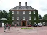 | |||
| Sidmount Avenue Sidmount Cottage | 55°20′08″N 3°26′12″W | Category A | 37935 | | |||
| Well Road, Lauchope Lodge | 55°20′12″N 3°26′03″W | Category C(S) | 37948 | | |||
| 25 Well Street | 55°19′59″N 3°26′34″W | Category B | 37952 | | |||
| 13 Beechgrove Buchan House | 55°20′15″N 3°26′50″W | Category B | 37873 | | |||
| Church Gate St Andrew's Parish Church Manse | 55°19′53″N 3°26′42″W | Category B | 37882 | | |||
| Church Gate Harthope House | 55°19′55″N 3°26′38″W | Category B | 37884 | | |||
| 3 Church Street | 55°19′58″N 3°26′41″W | Category B | 37886 | | |||
| Eastgate Albert House | 55°20′05″N 3°26′42″W | Category C(S) | 37893 | | |||
| Haywood Road Woodlands | 55°20′12″N 3°26′06″W | Category B | 37901 | | |||
| High Street Arden House | 55°20′03″N 3°26′42″W | Category B | 37904 | | |||
| High Street 4 Bath Place | 55°20′02″N 3°26′40″W | Category B | 37906 | | |||
| Well Road, Burnock Lodge (East Side) | 55°20′18″N 3°26′00″W | Category B | 37941 | | |||
| 23 Well Road (North Side) | 55°20′00″N 3°26′26″W | Category C(S) | 37942 | | |||
| Craigieburn Hermitage | 55°20′02″N 3°23′48″W | Category C(S) | 16850 | | |||
| Crofthead Farmhouse And Steading | 55°20′01″N 3°23′03″W | Category C(S) | 16853 | | |||
| Dumcrieff House | 55°19′06″N 3°25′00″W | Category B | 16856 | | |||
| Moffat Well | 55°21′01″N 3°25′58″W | Category B | 16865 | | |||
| 16 Beechgrove | 55°20′16″N 3°26′52″W | Category C(S) | 37875 | | |||
| Churchgate St Andrew's Parish Church | 55°19′54″N 3°26′41″W | Category A | 37881 | 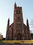 | |||
| Haywood Road North Park | 55°20′14″N 3°26′04″W | Category B | 37900 | | |||
| High Street Star Hotel | 55°19′58″N 3°26′37″W | Category C(S) | 37914 | | |||
| High Street J Hyslop And Co Premises | 55°19′57″N 3°26′37″W | Category B | 37915 | | |||
| High Street, Bank Of Scotland | 55°19′56″N 3°26′38″W | Category C(S) | 37919 | | |||
| 9 High Street, Gemini Jewellers | 55°19′58″N 3°26′40″W | Category C(S) | 37925 | | |||
| Old Well Road, Alma And 1 Well Road | 55°20′01″N 3°26′31″W | Category C(S) | 37930 | | |||
| Old Well Road Davington House | 55°20′05″N 3°26′29″W | Category C(S) | 37932 | | |||
| Star Street Range Of Cottages To Rear Of Star Inn | 55°19′58″N 3°26′35″W | Category C(S) | 37936 | | |||
| 2 Well Road Park House (South Side) | 55°20′00″N 3°26′31″W | Category B | 37938 | | |||
| Well Road Burnside (South Side) | 55°20′05″N 3°26′03″W | Category B | 37940 | | |||
| Craigieburn House | 55°20′06″N 3°23′43″W | Category B | 16849 | | |||
| Craigieburn, Lodge And Gatepiers | 55°19′59″N 3°23′40″W | Category C(S) | 16851 | |
Key
The scheme for classifying buildings in Scotland is:
- Category A: "buildings of national or international importance, either architectural or historic; or fine, little-altered examples of some particular period, style or building type."[1]
- Category B: "buildings of regional or more than local importance; or major examples of some particular period, style or building type, which may have been altered."[1]
- Category C: "buildings of local importance; lesser examples of any period, style, or building type, as originally constructed or moderately altered; and simple traditional buildings which group well with other listed buildings."[1]
In March 2016 there were 47,288 listed buildings in Scotland. Of these, 8% were Category A, and 50% were Category B, with the remaining 42% being Category C.[2]
Notes
- Sometimes known as OSGB36, the grid reference (where provided) is based on the British national grid reference system used by the Ordnance Survey.
• "Guide to National Grid". Ordnance Survey. Retrieved 2007-12-12.
• "Get-a-map". Ordnance Survey. Retrieved 2007-12-17. - Historic Environment Scotland assign a unique alphanumeric identifier to each designated site in Scotland, for listed buildings this always begins with "LB", for example "LB12345".
References
- All entries, addresses and coordinates are based on data from Historic Scotland. This data falls under the Open Government Licence
- "What is Listing?". Historic Environment Scotland. Retrieved 29 May 2018.
- Scotland's Historic Environment Audit 2016 (PDF). Historic Environment Scotland and the Built Environment Forum Scotland. pp. 15–16. Retrieved 29 May 2018.
This article is issued from Wikipedia. The text is licensed under Creative Commons - Attribution - Sharealike. Additional terms may apply for the media files.