List of listed buildings in Ayton, Scottish Borders
List
| Name | Location | Date Listed | Grid Ref. [note 1] | Geo-coordinates | Notes | LB Number [note 2] | Image |
|---|---|---|---|---|---|---|---|
| Prenderguest Farmhouse Including Walled Garden, Boundary Walls, Gatepiers And Gates | 55°49′43″N 2°07′59″W | Category B | 1991 |  | |||
| Railway Bridges, Near Peelwalls House | 55°49′52″N 2°07′26″W | Category C(S) | 4 | | |||
| Ayton, High Street, Ash Villa Including Boundary Wall | 55°50′38″N 2°07′35″W | Category C(S) | 46432 | | |||
| Ayton, High Street, Moffat House | 55°50′31″N 2°07′21″W | Category B | 46438 | 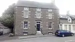 | |||
| Ayton Castle, Walled Garden Including Potting Sheds And Summerhouse | 55°50′37″N 2°07′06″W | Category B | 46447 | | |||
| Ayton Parish Church, Church Of Scotland, Including Boundary Walls, Railings, Gatepiers, Gates And War Memorial | 55°50′26″N 2°07′05″W | Category A | 46451 | 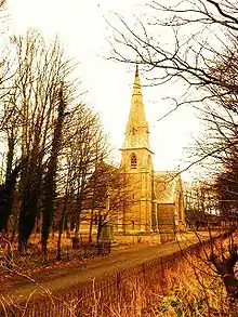 | |||
| Burnmouth, 14 - 20 (Inclusive Nos) Lower Burnmouth | 55°50′26″N 2°03′55″W | Category B | 46452 | | |||
| Littledean Farmhouse Including Garden Walls | 55°51′18″N 2°07′49″W | Category B | 46457 | | |||
| Millbank Stables Boundary Walls, Quadrant Walls, Piers And Gatepiers | 55°51′19″N 2°06′17″W | Category C(S) | 46459 | | |||
| West Flemington Farmhouse Including Garden Walls | 55°50′27″N 2°05′50″W | Category B | 46468 | | |||
| Ayton Castle, Dovecot | 55°50′47″N 2°06′47″W | Category A | 1989 | | |||
| Ayton, High Street, Red Lion Hotel Including Boundary Walls | 55°50′36″N 2°07′32″W | Category C(S) | 8 | | |||
| Ayton, Beanburn, Summerhill Including Former Coach House | 55°50′30″N 2°07′31″W | Category B | 46430 |  | |||
| Ayton Mains Farmhouse Including Garden Walls, Quadrant Walls And Gatepiers | 55°51′08″N 2°06′22″W | Category B | 46449 | | |||
| Ayton Castle, South Lodge Including Screen Walls And Piers | 55°50′29″N 2°07′12″W | Category B | 1988 | | |||
| Gunsgreenhill, Old Windmill | 55°52′00″N 2°05′07″W | Category C(S) | 5 | | |||
| Ayton, Old Town, Hillside Including Boundary Wall | 55°50′36″N 2°07′15″W | Category C(S) | 10 | | |||
| Ayton, 7 And 9 High Street | 55°50′33″N 2°07′25″W | Category B | 46431 | | |||
| Ayton, Old Town, Melville House Including Ancillary Structure, Boundary Wall, Railings, Gatepier And Gates | 55°50′32″N 2°07′21″W | Category C(S) | 46444 | | |||
| Netherbyres House Including Boundary Walls And Gatepiers | 55°51′54″N 2°05′36″W | Category B | 46460 | | |||
| Peelwalls South Lodge | 55°49′54″N 2°07′29″W | Category C(S) | 46464 | | |||
| Peelwalls Walled Garden | 55°49′59″N 2°07′37″W | Category C(S) | 46465 | | |||
| Burnmouth Harbour | 55°50′30″N 2°04′02″W | Category B | 11 | 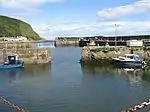 | |||
| Ayton, Beanburn, Summerhill Including Ancillary Structure And Boundary Wall | 55°50′26″N 2°07′39″W | Category B | 46429 | | |||
| Ayton, High Street, Clock Tower House | 55°50′35″N 2°07′28″W | Category C(S) | 46435 | | |||
| Ayton, High Street, Oaklands Including Boundary Walls And Railings | 55°50′38″N 2°07′39″W | Category C(S) | 46439 | | |||
| Ayton, High Street, Sawmill House Including Boundary Walls | 55°50′37″N 2°07′37″W | Category C(S) | 46443 | | |||
| 1 And 2, 3 And 4 Ayton Mains Farm Cottages Including Cobbled Paths And Garden Walls | 55°51′10″N 2°06′24″W | Category C(S) | 46448 | | |||
| Ayton Mill Farmhouse Including Ancillary Structure And Boundary Walls | 55°50′26″N 2°07′19″W | Category C(S) | 46450 | | |||
| Netherbyres House, The Coach House And Stable Courtyard Including Cobbled Courtyard, Courtyard Walls, Gatepiers And Ancillary Structures | 55°51′51″N 2°05′40″W | Category C(S) | 46461 | | |||
| Ayton Castle Including Service Courtyard, Courtyard Walls And Garden Rampart Walls | 55°50′44″N 2°06′54″W | Category A | 1987 | 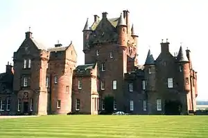 | |||
| Peelwalls House Including Garden Walls, Boundary Walls, Railings, Quadrant Walls, Railings, Piers, Gatepiers And Gates | 55°49′59″N 2°07′34″W | Category B | 1990 | | |||
| Glebe House (Formerly Ayton Manse) Including Boundary Walls, Railings, Quadrant Walls, Gatepiers And Gates | 55°50′23″N 2°07′14″W | Category C(S) | 1 | | |||
| Ayton, Beanburn, Heatherbank Including Boundary Wall And Gatepiers | 55°50′30″N 2°07′27″W | Category C(S) | 46426 | | |||
| Ayton, Beanburn, The Retreat Including Former Coach House And Boundary Wall | 55°50′30″N 2°07′34″W | Category C(S) | 46428 | | |||
| Ayton, High Street, Beech Villa Including Boundary Wall | 55°50′38″N 2°07′37″W | Category C(S) | 46434 | | |||
| Ayton, High Street, St Margaret's Including Boundary Walls | 55°50′35″N 2°07′31″W | Category C(S) | 46442 | | |||
| Ayton Castle, North Lodge Including Gatepiers | 55°50′52″N 2°06′52″W | Category C(S) | 46445 | | |||
| Greystonelees Farmhouse Including Garden Walls, Quadrant Walls And Gatepiers | 55°50′14″N 2°04′18″W | Category C(S) | 46456 | | |||
| Ayton, High Street, The Rowans Including Boundary Wall And Piers | 55°50′38″N 2°07′39″W | Category C(S) | 46441 | | |||
| Whiterig Farmhouse Including Courtyard Walls And Gatepiers, And Walled Garden | 55°49′16″N 2°07′36″W | Category B | 46469 | | |||
| St Dionysius' Church (Remains Of) | 55°50′30″N 2°07′00″W | Category B | 1986 | | |||
| Ayton, Beanburn, Kirklands Including Former Coach House, Boundary Wall And Gatepiers | 55°50′30″N 2°07′35″W | Category C(S) | 46427 | | |||
| Ayton, High Street, Beech Cottage Including Boundary Wall | 55°50′38″N 2°07′38″W | Category C(S) | 46433 | | |||
| Ayton, High Street, The Old Schoolhouse Including Boundary Wall | 55°50′35″N 2°07′30″W | Category C(S) | 46440 | | |||
| Burnmouth, Station House | 55°50′35″N 2°04′32″W | Category C(S) | 46453 | | |||
| Fairnieside Farmhouse Including Garden Walls | 55°50′44″N 2°05′15″W | Category C(S) | 46455 | | |||
| Peelwalls North Lodge | 55°50′02″N 2°07′27″W | Category C(S) | 46463 | | |||
| Ayton, High Street, Colville House Including Boundary Wall And Gatepiers | 55°50′38″N 2°07′34″W | Category B | 46436 | | |||
| Ayton, High Street, Colville Lodge Including Boundary Wall And Gatepiers | 55°50′37″N 2°07′33″W | Category B | 46437 | | |||
| Ayton Castle, Stable Courtyard | 55°50′50″N 2°06′51″W | Category B | 46446 | | |||
| Chesterbank Farmhouse Including Garden Walls | 55°50′27″N 2°05′01″W | Category C(S) | 46454 | | |||
| Millbank Lodge Including Quadrant Walls, Piers And Gatepiers | 55°51′17″N 2°06′13″W | Category C(S) | 46458 | | |||
| Netherbyres House, Walled Garden | 55°51′55″N 2°05′30″W | Category B | 46462 | | |||
| St Dionysius' Church (Remains Of), Graveyard Including Gatepiers And Gates | 55°50′30″N 2°06′58″W | Category B | 46466 | | |||
| West Flemington Farm Steading | 55°50′27″N 2°05′47″W | Category B | 46467 | |
Key
The scheme for classifying buildings in Scotland is:
- Category A: "buildings of national or international importance, either architectural or historic; or fine, little-altered examples of some particular period, style or building type."[1]
- Category B: "buildings of regional or more than local importance; or major examples of some particular period, style or building type, which may have been altered."[1]
- Category C: "buildings of local importance; lesser examples of any period, style, or building type, as originally constructed or moderately altered; and simple traditional buildings which group well with other listed buildings."[1]
In March 2016 there were 47,288 listed buildings in Scotland. Of these, 8% were Category A, and 50% were Category B, with the remaining 42% being Category C.[2]
Notes
- Sometimes known as OSGB36, the grid reference (where provided) is based on the British national grid reference system used by the Ordnance Survey.
• "Guide to National Grid". Ordnance Survey. Retrieved 2007-12-12.
• "Get-a-map". Ordnance Survey. Retrieved 2007-12-17. - Historic Environment Scotland assign a unique alphanumeric identifier to each designated site in Scotland, for listed buildings this always begins with "LB", for example "LB12345".
References
- All entries, addresses and coordinates are based on data from Historic Scotland. This data falls under the Open Government Licence
- "What is Listing?". Historic Environment Scotland. Retrieved 29 May 2018.
- Scotland's Historic Environment Audit 2016 (PDF). Historic Environment Scotland and the Built Environment Forum Scotland. pp. 15–16. Retrieved 29 May 2018.
This article is issued from Wikipedia. The text is licensed under Creative Commons - Attribution - Sharealike. Additional terms may apply for the media files.