List of listed buildings in Lauder, Scottish Borders
List
| Name | Location | Date Listed | Grid Ref. [note 1] | Geo-coordinates | Notes | LB Number [note 2] | Image |
|---|---|---|---|---|---|---|---|
| Mid Row, Lauder Town Hall | 55°43′09″N 2°44′53″W | Category B | 37201 |  | |||
| 7 Mid Row | 55°43′09″N 2°44′51″W | Category C(S) | 37214 | | |||
| 13 West High Street | 55°43′13″N 2°45′00″W | Category C(S) | 37219 | | |||
| 1-3 (Inclusive Nos) The Loan | 55°43′17″N 2°45′13″W | Category C(S) | 37225 | | |||
| 6 Mill Wynd, Including Railed Wall | 55°43′04″N 2°44′56″W | Category B | 37226 | | |||
| 28 And 30 East High Street | 55°43′06″N 2°44′42″W | Category C(S) | 47660 | | |||
| Thirlestane Castle Estate, Garden Cottage | 55°43′41″N 2°45′15″W | Category C(S) | 51314 | | |||
| East High Street, Lauder Church (Church Of Scotland), Including Entrance Gates And Churchyard Wall | 55°43′08″N 2°44′54″W | Category A | 37200 | | |||
| 20-24 (Even Nos) Market Place | 55°43′09″N 2°44′54″W | Category C(S) | 37204 | | |||
| 22-26 (Even Nos) West High Street | 55°43′12″N 2°45′01″W | Category C(S) | 37217 | | |||
| 1 The Row | 55°43′18″N 2°45′08″W | Category C(S) | 37224 | | |||
| Market Place, K6 Telephone Kiosk To N Of Lauder Post Office At No 18 | 55°43′10″N 2°44′55″W | Category B | 37228 | | |||
| Harryburn House Including Stables, Gates, Gatepiers And Railings | 55°43′35″N 2°45′31″W | Category B | 13406 | | |||
| 3 East High Street | 55°43′10″N 2°44′52″W | Category C(S) | 47655 | | |||
| 4 The Loan | 55°43′17″N 2°45′15″W | Category C(S) | 47666 | | |||
| 5-7 (Inclusive Nos) The Loan | 55°43′16″N 2°45′16″W | Category C(S) | 47667 | | |||
| Norton Farmhouse | 55°43′49″N 2°44′02″W | Category C(S) | 51313 | | |||
| 1 East High Street | 55°43′11″N 2°44′53″W | Category C(S) | 37203 | | |||
| 1 Market Place, The Eagle Hotel, Including Outbuildings To North East | 55°43′12″N 2°44′57″W | Category C(S) | 37206 | | |||
| 59 West High Street | 55°43′17″N 2°45′08″W | Category C(S) | 37222 | | |||
| The Loan, Lea Park | 55°43′16″N 2°45′19″W | Category C(S) | 47669 | | |||
| Terrace At Loan View, Including Nos 1 And 2 And 63 West High Street | 55°43′18″N 2°45′09″W | Category C(S) | 47670 | | |||
| Castle Wynd, Hume Lodge Including Boundary Wall To N And W | 55°43′19″N 2°45′01″W | Category C(S) | 51309 | | |||
| Chuckie Lodge (Formerly Harryburn Lodge) | 55°43′33″N 2°45′24″W | Category B | 51310 | | |||
| Thirlestane Castle Estate, Walled Garden | 55°43′39″N 2°45′10″W | Category C(S) | 51316 | | |||
| 9 Market Place, Black Bull Hotel | 55°43′11″N 2°44′54″W | Category B | 37202 | | |||
| 53 And 55 (Odd Nos) West High Street | 55°43′17″N 2°45′07″W | Category C(S) | 37221 | | |||
| Lauder Bridge (Eagle Bridge) | 55°43′02″N 2°43′55″W | Category B | 8204 | | |||
| 32 And 34 East High Street, Including Terrace Wall And Railings | 55°43′05″N 2°44′42″W | Category C(S) | 47661 | | |||
| 7 And 9 Factor's Park | 55°43′06″N 2°44′50″W | Category C(S) | 47665 | | |||
| 1-5 (Odd Nos) Mid Row, Including Bank Of Scotland | 55°43′09″N 2°44′52″W | Category C(S) | 47673 | | |||
| 3 The Row | 55°43′18″N 2°45′07″W | Category B | 47674 | | |||
| 7 The Row | 55°43′18″N 2°45′07″W | Category C(S) | 47675 | | |||
| Allanbank Including Allanbank Cottage, Stables And Walled Garden | 55°43′07″N 2°45′29″W | Category C(S) | 50908 | | |||
| 43 West High Street | 55°43′16″N 2°45′04″W | Category B | 45581 | | |||
| 3-5 (Odd Nos) Market Place, Including Premises Of A & J Rutherford | 55°43′11″N 2°44′56″W | Category C(S) | 37207 | | |||
| 49 West High Street | 55°43′16″N 2°45′05″W | Category C(S) | 37220 | | |||
| Edinburgh Road, War Memorial | 55°43′17″N 2°45′14″W | Category B | 37223 | | |||
| 12 The Loan And Adjoining Former Cottage | 55°43′16″N 2°45′17″W | Category C(S) | 47668 | | |||
| Lauder Golf Club Pavilion | 55°42′40″N 2°45′02″W | Category C(S) | 51312 | | |||
| 4 The Avenue | 55°43′14″N 2°44′56″W | Category C(S) | 47654 | | |||
| 35 East High Street | 55°43′08″N 2°44′46″W | Category C(S) | 47656 | | |||
| 38 East High Street | 55°43′03″N 2°44′34″W | Category C(S) | 47662 | | |||
| East High Street, Wyndhead Farm, Barn To North East (Parallel To East High Street) And Cart Shed Attached To Adjoining Block To South West Only | 55°43′02″N 2°44′33″W | Category C(S) | 47664 | | |||
| 61 West High Street | 55°43′18″N 2°45′09″W | Category C(S) | 47679 | | |||
| Thirlestane Castle Estate, Stable Offices | 55°43′03″N 2°44′28″W | Category B | 51315 | | |||
| Manse Road, The Glebe (Former Lauder Manse) Including Stable And Boundary Wall | 55°43′01″N 2°45′17″W | Category B | 6717 | | |||
| 8 East High Street | 55°43′07″N 2°44′47″W | Category C(S) | 47657 | | |||
| 40 East High Street Including Rear Wing And Courtyard | 55°43′02″N 2°44′32″W | Category C(S) | 47663 | | |||
| Manse Road, Lodge At Entrance To Allanbank House, Including Railings | 55°43′09″N 2°45′07″W | Category C(S) | 47671 | | |||
| 47 West High Street | 55°43′16″N 2°45′05″W | Category C(S) | 47678 | | |||
| East High Street, Wyndhead Stables Lodge | 55°43′03″N 2°44′32″W | Category C(S) | 51311 | | |||
| Drummonds Hall, Bridge | 55°43′37″N 2°43′51″W | Category B | 13847 | | |||
| Thirlestane Castle (Including Eagle Gates And Boundary Walls) | 55°43′20″N 2°44′37″W | Category A | 8203 | 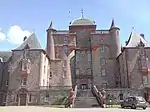 | |||
| 10 East High Street, Including Boundary Wall | 55°43′06″N 2°44′47″W | Category C(S) | 47658 | | |||
| 26 East High Street | 55°43′06″N 2°44′43″W | Category C(S) | 47659 | | |||
| 12 The Row | 55°43′18″N 2°45′03″W | Category C(S) | 47676 | | |||
| 19 West High Street | 55°43′14″N 2°45′01″W | Category C(S) | 47677 | |
Key
The scheme for classifying buildings in Scotland is:
- Category A: "buildings of national or international importance, either architectural or historic; or fine, little-altered examples of some particular period, style or building type."[1]
- Category B: "buildings of regional or more than local importance; or major examples of some particular period, style or building type, which may have been altered."[1]
- Category C: "buildings of local importance; lesser examples of any period, style, or building type, as originally constructed or moderately altered; and simple traditional buildings which group well with other listed buildings."[1]
In March 2016 there were 47,288 listed buildings in Scotland. Of these, 8% were Category A, and 50% were Category B, with the remaining 42% being Category C.[2]
Notes
- Sometimes known as OSGB36, the grid reference (where provided) is based on the British national grid reference system used by the Ordnance Survey.
• "Guide to National Grid". Ordnance Survey. Retrieved 12 December 2007.
• "Get-a-map". Ordnance Survey. Retrieved 17 December 2007. - Historic Environment Scotland assign a unique alphanumeric identifier to each designated site in Scotland, for listed buildings this always begins with "LB", for example "LB12345".
References
- All entries, addresses and coordinates are based on data from Historic Scotland. This data falls under the Open Government Licence
- "What is Listing?". Historic Environment Scotland. Retrieved 29 May 2018.
- Scotland's Historic Environment Audit 2016 (PDF). Historic Environment Scotland and the Built Environment Forum Scotland. pp. 15–16. Retrieved 29 May 2018.
This article is issued from Wikipedia. The text is licensed under Creative Commons - Attribution - Sharealike. Additional terms may apply for the media files.