List of listed buildings in Linton, Scottish Borders
List
| Name | Location | Date Listed | Grid Ref. [note 1] | Geo-coordinates | Notes | LB Number [note 2] | Image |
|---|---|---|---|---|---|---|---|
| Clifton Park, Stables And Coach House Including Setted Courtyard | 55°31′57″N 2°22′29″W | Category C(S) | 44973 |  | |||
| Carlops, Lynburn Including Garden Grotto And Linburn Cottage | 55°47′15″N 3°20′23″W | Category B | 8384 | | |||
| Carlops, Row Of 6 Cottages (Ferndale, Houlet, Amulree, Finlaggan, Blinkieknowe, Birkenbush) | 55°47′21″N 3°20′23″W | Category B | 8386 | | |||
| Carlops, Row Of 4 Cottages (Springbank, Carberry, Langskaill, Jess) | 55°47′26″N 3°20′22″W | Category C(S) | 8390 | | |||
| Carlops, Mill Lane, Bridge Over River Esk At Patie's Mill | 55°47′30″N 3°20′20″W | Category C(S) | 8364 | | |||
| West Linton, The Loan, Srongarbh Including Railings, Boundary Walls, Garages, Garden Terraces And Steps, Swimming Pool, Pavilion And Other Ancillary Structures | 55°45′25″N 3°21′51″W | Category A | 51069 | 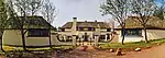 | |||
| Carlops, Carlops Parish Church | 55°47′21″N 3°20′23″W | Category C(S) | 51627 | | |||
| Linton Church, Stables And Outbuildings | 55°31′47″N 2°21′41″W | Category C(S) | 44978 | | |||
| Old Graden Mansion House Including Outbuilding, Summerhouse, Boundary Walls, Gatepiers And Gates | 55°33′45″N 2°19′22″W | Category C(S) | 44980 | | |||
| Carlops, Allan Ramsay Hotel | 55°47′26″N 3°20′24″W | Category B | 13687 | | |||
| Carlops, Row Of 3 Cottages (Ashley, The Biggin, Weavers) | 55°47′23″N 3°20′22″W | Category B | 8387 | | |||
| Paulswell Farmhouse And Steading | 55°43′47″N 3°20′24″W | Category C(S) | 8334 | | |||
| Spitalhaugh House Including Stable And Bridge | 55°43′59″N 3°20′06″W | Category A | 8361 | | |||
| Carlops, Vallence Cottage | 55°47′29″N 3°20′20″W | Category C(S) | 8362 | | |||
| Medwynhead House | 55°44′54″N 3°26′55″W | Category C(S) | 8366 | | |||
| Hoselaw Chapel (Church Of Scotland) Including Boundary Walls And Gate | 55°34′45″N 2°18′58″W | Category A | 18799 | 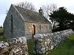 | |||
| West Linton, Main Street, Gifford Stones House | 55°45′08″N 3°21′21″W | Category A | 12888 | | |||
| Carlops, Pentlands And Elphinstone | 55°47′24″N 3°20′24″W | Category C(S) | 8388 | | |||
| West Linton, Bogsbank Road, Greenfield (Former St Andrew's Manse) | 55°44′57″N 3°21′26″W | Category B | 8353 | | |||
| West Linton, War Memorial | 55°45′01″N 3°21′23″W | Category C(S) | 8356 | | |||
| West Linton, Old Manor House | 55°45′13″N 3°21′22″W | Category C(S) | 8358 | 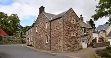 | |||
| Medwyn House | 55°45′22″N 3°22′06″W | Category B | 8360 | | |||
| Spitalhaugh, Doocot House | 55°44′00″N 3°20′09″W | Category C(S) | 51628 | | |||
| Deepsykehead Farmhouse And Stable Offices | 55°46′41″N 3°19′11″W | Category C(S) | 13684 | | |||
| West Linton, St Andrew's Parish Church Including Burial Ground, Gatepiers And Boundary Walls | 55°45′03″N 3°21′22″W | Category B | 12889 | 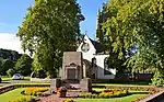 | |||
| Carlops, Carlops Mains Including Barn | 55°47′20″N 3°20′18″W | Category B | 8383 | | |||
| Carlops, Drinking Fountain | 55°47′28″N 3°20′22″W | Category B | 8389 | | |||
| West Linton, Clock Tower And Public Bell | 55°45′06″N 3°21′21″W | Category B | 8359 | 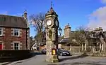 | |||
| Kitley Brig, Lodge And Gatepiers | 55°47′24″N 3°19′29″W | Category B | 8365 | | |||
| Clifton Park, Clifton Lodge Including Entrance Walls, Piers, Gatepiers And Boundary Wall | 55°32′03″N 2°22′00″W | Category C(S) | 44971 | | |||
| Clifton Park, Ice House | 55°31′58″N 2°22′20″W | Category C(S) | 44972 | | |||
| Clifton Park, Walled Garden Including Shed | 55°31′52″N 2°22′32″W | Category C(S) | 44974 | | |||
| Frogden Farmhouse Including Outbuilding, Summerhouse, Sundial, Boundary Walls And Gatepiers | 55°32′47″N 2°22′36″W | Category C(S) | 44975 | | |||
| Graden Farm, Cartshed And Granary | 55°34′14″N 2°19′25″W | Category B | 44976 | | |||
| Lindenlea, Carlops | 55°47′16″N 3°20′23″W | Category B | 8385 | | |||
| Garvald Home Farm, Courtyard Range Including Farmhouse And Separate Barn | 55°43′42″N 3°26′15″W | Category B | 8382 | | |||
| West Linton, Carlops Road, Lynehurst | 55°45′07″N 3°21′33″W | Category C(S) | 51631 | | |||
| Linton Manse Cottage | 55°31′48″N 2°21′30″W | Category C(S) | 44979 | | |||
| West Linton, Chapel Brae, The Rectory (Former St Mungo's Manse) | 55°45′06″N 3°21′33″W | Category C(S) | 51630 | | |||
| West Linton, St Andrew's Church Hall (Former Somervail School) | 55°45′07″N 3°21′33″W | Category C(S) | 51632 | | |||
| Linton Church (Church Of Scotland) Including Graveyard, Boundary Walls, Gates And Gateposts | 55°31′45″N 2°21′38″W | Category B | 15254 | | |||
| Garvald House Including Former Stables, Former Coach House, Walled Garden And Lodge | 55°43′33″N 3°26′11″W | Category B | 8381 | | |||
| West Linton, Former Toll House | 55°45′00″N 3°21′23″W | Category C(S) | 8355 | | |||
| West Linton, Raemartin Square, Raemartin House (Former Raemartin Hotel) | 55°45′08″N 3°21′22″W | Category B | 8357 | | |||
| West Linton, Chapel Brae, St Mungo's Episcopal Church | 55°45′07″N 3°21′33″W | Category C(S) | 51629 | 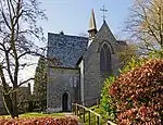 |
Key
The scheme for classifying buildings in Scotland is:
- Category A: "buildings of national or international importance, either architectural or historic; or fine, little-altered examples of some particular period, style or building type."[1]
- Category B: "buildings of regional or more than local importance; or major examples of some particular period, style or building type, which may have been altered."[1]
- Category C: "buildings of local importance; lesser examples of any period, style, or building type, as originally constructed or moderately altered; and simple traditional buildings which group well with other listed buildings."[1]
In March 2016 there were 47,288 listed buildings in Scotland. Of these, 8% were Category A, and 50% were Category B, with the remaining 42% being Category C.[2]
Notes
- Sometimes known as OSGB36, the grid reference (where provided) is based on the British national grid reference system used by the Ordnance Survey.
• "Guide to National Grid". Ordnance Survey. Retrieved 2007-12-12.
• "Get-a-map". Ordnance Survey. Retrieved 2007-12-17. - Historic Environment Scotland assign a unique alphanumeric identifier to each designated site in Scotland, for listed buildings this always begins with "LB", for example "LB12345".
References
- All entries, addresses and coordinates are based on data from Historic Scotland. This data falls under the Open Government Licence
- "What is Listing?". Historic Environment Scotland. Retrieved 29 May 2018.
- Scotland's Historic Environment Audit 2016 (PDF). Historic Environment Scotland and the Built Environment Forum Scotland. pp. 15–16. Retrieved 29 May 2018.
This article is issued from Wikipedia. The text is licensed under Creative Commons - Attribution - Sharealike. Additional terms may apply for the media files.