List of listed buildings in Eyemouth, Scottish Borders
List
| Name | Location | Date Listed | Grid Ref. [note 1] | Geo-coordinates | Notes | LB Number [note 2] | Image |
|---|---|---|---|---|---|---|---|
| 3, 4, 5 Armatage Street | 55°52′20″N 2°05′26″W | Category C(S) | 31119 |  | |||
| 7-11 Armatage Street | 55°52′20″N 2°05′25″W | Category C(S) | 31121 | | |||
| 11 Church Street, Chester House | 55°52′17″N 2°05′22″W | Category A | 31128 | | |||
| 6 High Street J Thomson Hairdressers | 55°52′21″N 2°05′23″W | Category C(S) | 31144 | | |||
| Market Place Wilbara House And R A Mcivor Chemist | 55°52′21″N 2°05′21″W | Category B | 31147 | | |||
| 49 6 St Ella's Place | 55°52′21″N 2°05′19″W | Category C(S) | 31161 | | |||
| 12, 13, 14 St Ella's Place | 55°52′22″N 2°05′20″W | Category B | 31163 | | |||
| Victoria Road Eyemouth Parish Church | 55°52′11″N 2°05′28″W | Category C(S) | 31166 | | |||
| 9 Church Street | 55°52′17″N 2°05′22″W | Category C(S) | 31127 | | |||
| 7 High Street And David Allan Newsagent | 55°52′20″N 2°05′24″W | Category C(S) | 31141 | | |||
| 1 Marine Parade (Eyemouth Harbour Trust) | 55°52′22″N 2°05′14″W | Category C(S) | 31149 | | |||
| New Quay Eyemouth Harbour | 55°52′19″N 2°05′12″W | Category C(S) | 31153 | | |||
| 3 Old Quay Harbour Road | 55°52′22″N 2°05′14″W | Category C(S) | 31154 | | |||
| Old Quay Harbour Road Joiners' Yard To Rear Of No 4 Old Quay (Cook And Martin Joiners) | 55°52′22″N 2°05′14″W | Category C(S) | 31156 | | |||
| Linthill House | 55°51′39″N 2°07′08″W | Category B | 10489 | | |||
| 18 Albert Road Viewfield Cottage | 55°52′16″N 2°05′25″W | Category C(S) | 31115 | | |||
| 6 Armatage Street | 55°52′20″N 2°05′26″W | Category C(S) | 31120 | | |||
| 13 Church Street | 55°52′17″N 2°05′22″W | Category C(S) | 31129 | | |||
| 36 Church Street | 55°52′14″N 2°05′24″W | Category C(S) | 31132 | | |||
| Gunsgreen House Gatepiers And Gates | 55°52′19″N 2°05′10″W | Category C(S) | 31135 | | |||
| 4, 6 Market Place Including Eyemouth Library | 55°52′19″N 2°05′21″W | Category B | 31146 | | |||
| Old Quay Harbour Road The Whale Hotel | 55°52′21″N 2°05′15″W | Category C(S) | 31157 | | |||
| 8 St Ella's Place And 2 St Ella's Wynd | 55°52′22″N 2°05′19″W | Category C(S) | 31162 | | |||
| 12, 14, 16 Albert Road St John's House | 55°52′15″N 2°05′25″W | Category B | 31114 | | |||
| Brown's Bank Eyemouth Boatbuilding Co | 55°52′09″N 2°05′23″W | Category C(S) | 31122 | | |||
| 1 Chapel Street | 55°52′20″N 2°05′21″W | Category C(S) | 31123 | | |||
| 28, 29, 30 Harbour Road | 55°52′16″N 2°05′19″W | Category C(S) | 31136 | | |||
| High Street And Albert Road Old Churchyard And Watch-House | 55°52′23″N 2°05′31″W | Category B | 31142 | | |||
| 2 Market Place And Masons Wynd | 55°52′19″N 2°05′21″W | Category B | 31145 | | |||
| Market Place, Hurkar, Gift Shop | 55°52′21″N 2°05′22″W | Category C(S) | 31148 | | |||
| Old Quay Harbour Road Royal National Mission To Deep Sea Fishermen | 55°52′20″N 2°05′15″W | Category B | 31159 | | |||
| Albert Road Community Centre | 55°52′15″N 2°05′27″W | Category C(S) | 31113 | | |||
| 7, 7A And 9 Chapel Street, 2, 4 Queen Street, 2, 4, St Ella's Place | 55°52′20″N 2°05′19″W | Category C(S) | 31125 | | |||
| Church Street. Former Eyemouth Parish Church | 55°52′19″N 2°05′20″W | Category B | 31126 | | |||
| Church Street Burgh Chambers | 55°52′18″N 2°05′23″W | Category B | 31130 | | |||
| Church Street Evangelical Union Congregational Church | 55°52′16″N 2°05′24″W | Category C(S) | 31131 | | |||
| 2, 4 High Street T C Maltman & Son | 55°52′21″N 2°05′23″W | Category C(S) | 31143 | | |||
| St Ella's Wynd Aitcheson Brothers | 55°52′22″N 2°05′19″W | Category C(S) | 31165 | | |||
| 58 Albert Road And Ridley's Fish And Chip Shop | 55°52′19″N 2°05′27″W | Category C(S) | 31116 | | |||
| Albert Road Jasmine Cottage | 55°52′22″N 2°05′32″W | Category C(S) | 31117 | | |||
| Gunsgreen House And Terrace Retaining Wall. (Eyemouth Golf Club And Border Sailing Club) | 55°52′21″N 2°05′08″W | Category A | 31133 | 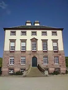 | |||
| 49 Harbour Road And 1 Victoria Road | 55°52′10″N 2°05′25″W | Category C(S) | 31140 | | |||
| Old Quay Harbour Road Collinville | 55°52′20″N 2°05′14″W | Category C(S) | 31158 | | |||
| 13, 14, 15 St Ella's Wynd And 1 Todds Court | 55°52′22″N 2°05′19″W | Category C(S) | 31164 | | |||
| 1, 2 Armatage Street | 55°52′21″N 2°05′25″W | Category C(S) | 31118 | | |||
| Chapel Street Wm Scott & Son | 55°52′21″N 2°05′21″W | Category C(S) | 31124 | | |||
| Gunsgreen House Dovecote | 55°52′18″N 2°05′08″W | Category B | 31134 | | |||
| 31-33 Harbour Road | 55°52′15″N 2°05′20″W | Category C(S) | 31137 | | |||
| 34 Harbour Road | 55°52′15″N 2°05′21″W | Category C(S) | 31138 | | |||
| Harbour Road Eyemouth Boat Building Co And Marine Radio | 55°52′11″N 2°05′23″W | Category B | 31139 | | |||
| 2,3 Marine Parade | 55°52′22″N 2°05′14″W | Category C(S) | 31150 | | |||
| Mason's Wynd John Waddell Fish Merchant, Fish Smoking House | 55°52′19″N 2°05′20″W | Category C(S) | 31152 | | |||
| 4 Old Quay Harbour Road 'The Contented Sole' | 55°52′22″N 2°05′13″W | Category C(S) | 31155 | | |||
| Old Quay Harbour Road Ship Hotel | 55°52′19″N 2°05′16″W | Category B | 31160 | |
Key
The scheme for classifying buildings in Scotland is:
- Category A: "buildings of national or international importance, either architectural or historic; or fine, little-altered examples of some particular period, style or building type."[1]
- Category B: "buildings of regional or more than local importance; or major examples of some particular period, style or building type, which may have been altered."[1]
- Category C: "buildings of local importance; lesser examples of any period, style, or building type, as originally constructed or moderately altered; and simple traditional buildings which group well with other listed buildings."[1]
In March 2016 there were 47,288 listed buildings in Scotland. Of these, 8% were Category A, and 50% were Category B, with the remaining 42% being Category C.[2]
Notes
- Sometimes known as OSGB36, the grid reference (where provided) is based on the British national grid reference system used by the Ordnance Survey.
• "Guide to National Grid". Ordnance Survey. Retrieved 12 December 2007.
• "Get-a-map". Ordnance Survey. Retrieved 17 December 2007. - Historic Environment Scotland assign a unique alphanumeric identifier to each designated site in Scotland, for listed buildings this always begins with "LB", for example "LB12345".
References
- All entries, addresses and coordinates are based on data from Historic Scotland. This data falls under the Open Government Licence
- "What is Listing?". Historic Environment Scotland. Retrieved 29 May 2018.
- Scotland's Historic Environment Audit 2016 (PDF). Historic Environment Scotland and the Built Environment Forum Scotland. pp. 15–16. Retrieved 29 May 2018.
This article is issued from Wikipedia. The text is licensed under Creative Commons - Attribution - Sharealike. Additional terms may apply for the media files.