List of listed buildings in Blair Atholl, Perth and Kinross
List
| Name | Location | Date Listed | Grid Ref. [note 1] | Geo-coordinates | Notes | LB Number [note 2] | Image |
|---|---|---|---|---|---|---|---|
| Cumhann-Leum Bridge Over River Tilt | 56°47′40″N 3°50′00″W | Category B | 6034 |  | |||
| Tenandry Church | 56°43′57″N 3°46′53″W | Category B | 6043 | | |||
| Bonskeid House | 56°43′42″N 3°48′36″W | Category B | 6047 | | |||
| West Lodge, Bonskeid | 56°43′38″N 3°49′31″W | Category C(S) | 6048 | | |||
| Black Castle (Caisteal Dubh) | 56°43′31″N 3°49′54″W | Category C(S) | 6049 | | |||
| Front Lodge, Blair Castle | 56°46′01″N 3°50′45″W | Category A | 6064 | | |||
| Grotto On River Tilt Opposite York Cascade | 56°46′29″N 3°50′29″W | Category A | 6065 | | |||
| Footbridge From Diana's Wilderness To Old Blair Garden | 56°46′37″N 3°51′22″W | Category C(S) | 6071 | | |||
| Garryside | 56°45′48″N 3°50′52″W | Category B | 6108 | | |||
| Viewpoint, Falls Of The Bruar | 56°46′34″N 3°55′52″W | Category C(S) | 6007 | | |||
| Gilbert's Bridge Over River Tilt | 56°48′31″N 3°50′03″W | Category B | 6035 | | |||
| Old Stables, Lude | 56°46′11″N 3°49′35″W | Category B | 6057 | | |||
| Old Bridge Of Tilt Atholl Bank Cottage, Drying Kiln Only | 56°46′34″N 3°50′19″W | Category B | 6058 | | |||
| Foot Bridge And Adjoining Garden Walls Over East Lodge Road Near Old Bridge Of Tilt | 56°46′32″N 3°50′28″W | Category C(S) | 6066 | | |||
| Sundial | 56°46′24″N 3°51′32″W | Category A | 6076 | 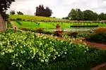 | |||
| The Obelisk | 56°46′31″N 3°51′32″W | Category B | 6083 | | |||
| Village Hall, Blair Atholl (Scottish Horse Drill Hall) | 56°45′57″N 3°50′46″W | Category B | 6104 | | |||
| Blair Cottages. (Post Office, Seaton, Shanto, Grant, Duncan And Wood) | 56°45′57″N 3°50′51″W | Category B | 6105 | | |||
| Auchleeks House, Stable Block | 56°45′17″N 4°03′45″W | Category B | 6002 | | |||
| Chamberbane Crucked Cottage (Now Store) | 56°42′54″N 3°55′46″W | Category B | 6004 | | |||
| South Bridge Over Falls Of The Bruar | 56°46′26″N 3°56′03″W | Category B | 6006 | | |||
| Tirinie Lodge | 56°47′03″N 3°49′31″W | Category C(S) | 6017 | | |||
| West Bridge Over Croft Crombie Burn, Glen Tilt | 56°47′50″N 3°50′29″W | Category C(S) | 6032 | | |||
| Dalnamein Bridge (Large) On Former Route Of A9 | 56°48′02″N 4°02′21″W | Category B | 50911 | | |||
| Killiecrankie Bridge Over River Garry | 56°43′40″N 3°46′33″W | Category B | 6041 | | |||
| Robert Stuart Of Fincastle Burial Enclosure 1/2 Mile S. Of Glen Fincastle Chapel | 56°43′53″N 3°50′56″W | Category C(S) | 6050 | | |||
| Fender Cottage, Fenderbridge | 56°46′44″N 3°50′00″W | Category C(S) | 6062 | | |||
| Old Blair Bridge Over Banvie Burn | 56°46′36″N 3°51′25″W | Category B | 6072 | | |||
| Blair Atholl War Memorial | 56°45′58″N 3°50′55″W | Category B | 6107 | | |||
| Tilt Railway Viaduct | 56°45′53″N 3°50′38″W | Category B | 6110 | | |||
| Tilt Cottages, Bridge Of Tilt | 56°46′01″N 3°50′15″W | Category C(S) | 6111 | | |||
| Auchleeks House, Walled Garden And Gates | 56°45′21″N 4°03′37″W | Category B | 6001 | | |||
| Bridge In Clunes Wood Over Allt A' Chrombaidh ('The Eye Of The Window') | 56°46′37″N 3°58′51″W | Category C(S) | 6010 | | |||
| Dail-An-Eas Bridge Over River Tilt | 56°51′04″N 3°44′31″W | Category B | 6037 | | |||
| Bridge Of Tilt Lodge, Lude | 56°46′06″N 3°50′23″W | Category B | 6055 | | |||
| Old Blair | 56°46′37″N 3°51′20″W | Category B | 6070 | | |||
| Bridge Over Banvie Burn In Diana's Wilderness, N. Of Item 39 | 56°46′29″N 3°51′28″W | Category C(S) | 6078 | | |||
| Statue Of Hercules | 56°46′27″N 3°51′01″W | Category B | 6081 | | |||
| The Dairy, The Mains | 56°46′17″N 3°51′26″W | Category C(S) | 6082 | | |||
| Kilmaveonaig Chapel (Episcopal) | 56°46′11″N 3°50′06″W | Category B | 6112 | | |||
| Bridge Over Banvie Burn N. Of The Whim | 56°46′59″N 3°52′12″W | Category C(S) | 6028 | | |||
| East Bridge Over Croft Crombie Burn, Glen Tilt | 56°47′50″N 3°50′26″W | Category C(S) | 6033 | | |||
| Gow's Bridge Over River Tilt | 56°49′29″N 3°48′07″W | Category B | 6036 | | |||
| Limekiln, Near Essangal | 56°45′30″N 3°48′53″W | Category B | 6038 | | |||
| Shierglas, Farmhouse | 56°45′24″N 3°49′36″W | Category B | 6039 | | |||
| Coillebrochaim | 56°43′27″N 3°47′07″W | Category C(S) | 6044 | | |||
| East Lodge, Bonskeid | 56°43′43″N 3°48′18″W | Category C(S) | 6046 | | |||
| Trinafour Sawmill | 56°45′23″N 4°05′06″W | Category C(S) | 6053 | | |||
| Bridge Over Fender. W. Of Fenderbridge | 56°46′41″N 3°50′13″W | Category C(S) | 6063 | | |||
| Bailanloan | 56°46′48″N 3°51′00″W | Category B | 6069 | | |||
| Parish Church, Blair Atholl | 56°46′00″N 3°50′36″W | Category B | 6101 | | |||
| Atholl Arms Hotel, Blair Atholl | 56°45′56″N 3°50′55″W | Category C(S) | 6106 | | |||
| North Bridge Over Falls Of The Bruar | 56°46′44″N 3°55′57″W | Category B | 6008 | | |||
| Tirinie House | 56°47′17″N 3°49′09″W | Category B | 6015 | | |||
| Lude House | 56°46′08″N 3°49′25″W | Category B | 6056 | | |||
| Pond Cottage, Lude | 56°46′12″N 3°49′35″W | Category B | 6060 | | |||
| 'Fenderbridge', Fenderbridge | 56°46′44″N 3°50′01″W | Category C(S) | 6061 | | |||
| Blair Castle | 56°46′24″N 3°51′27″W | Category A | 6074 | 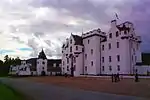 | |||
| Bridge Over Banvie Burn, N. Of Blair Castle | 56°46′27″N 3°51′26″W | Category C(S) | 6077 | | |||
| Walled Garden | 56°46′30″N 3°51′01″W | Category B | 6080 | | |||
| School And Schoolhouse, Blair Atholl | 56°46′01″N 3°50′33″W | Category C(S) | 6102 | | |||
| Struan Church And Churchyard | 56°45′52″N 3°57′00″W | Category B | 6003 | | |||
| Drochaid Dail An Fhrasich Bridge Over River Garry | 56°48′16″N 4°05′15″W | Category B | 6013 | | |||
| Dalnacardoch Lodge | 56°48′23″N 4°05′43″W | Category B | 6014 | | |||
| Old Manse Of Blair, Baluain | 56°46′15″N 3°54′18″W | Category C(S) | 6030 | | |||
| Ruins Of Lude Kirk, Kirkton Of Lude, Glen Fender | 56°47′51″N 3°47′51″W | Category B | 6031 | | |||
| Old Fincastle House | 56°44′15″N 3°51′09″W | Category A | 69 | | |||
| Killiecrankie Cottage | 56°44′30″N 3°46′36″W | Category B | 6042 | | |||
| Balavoulin (Milton Lodge On Map) | 56°43′54″N 3°50′37″W | Category B | 6051 | | |||
| Old Trinafour Bridge Over R. Errochty | 56°45′24″N 4°05′13″W | Category B | 6052 | | |||
| Obelisk, Tom-Na-Croiche (Balvenie Pillar) | 56°46′35″N 3°50′45″W | Category B | 6067 | | |||
| Terrace | 56°46′25″N 3°51′35″W | Category B | 6075 | | |||
| The Whim | 56°46′50″N 3°52′08″W | Category B | 6084 | | |||
| Bridge Of Tilt | 56°46′04″N 3°50′27″W | Category B | 6109 | | |||
| Struan Bridge Over Errochty Water | 56°45′51″N 3°56′59″W | Category B | 6005 | | |||
| Lady Jean's Well | 56°46′57″N 3°51′49″W | Category B | 6027 | | |||
| Tummel Garry Hydro Electric Scheme, Errochty Dam Including Tunnel Intake Gatehouse | 56°45′52″N 4°06′19″W | Category B | 51714 | | |||
| Shierglas Steading | 56°45′25″N 3°49′36″W | Category C(S) | 6040 | | |||
| Coille Bhrochain Cottage | 56°43′38″N 3°46′46″W | Category C(S) | 6045 | | |||
| Auchleeks House | 56°45′23″N 4°03′37″W | Category A | 6054 | | |||
| Lude Walled Garden | 56°45′59″N 3°49′09″W | Category C(S) | 6059 | | |||
| Blairuachdar | 56°47′15″N 3°50′41″W | Category B | 6068 | | |||
| St. Bride's Church, Old Blair | 56°46′34″N 3°51′18″W | Category B | 6073 | | |||
| Statue Of Diana And Actaeon, Diana's Wilderness | 56°46′33″N 3°51′32″W | Category B | 6079 | | |||
| Blair Atholl Mill | 56°45′53″N 3°50′50″W | Category B | 6103 | | |||
| Clunes Lodge | 56°46′47″N 3°59′46″W | Category B | 6009 | | |||
| Old Bridge Over Allt Anndeir, Near Dail-Na-Mine Lodge | 56°48′06″N 4°02′26″W | Category C(S) | 6011 | | |||
| Bruar Lodge, Glen Bruar | 56°46′17″N 3°55′52″W | Category C(S) | 6012 | | |||
| Tirinie Farmhouse And Steading | 56°36′51″N 3°58′07″W | Category C(S) | 6016 | | |||
| West Lodge | 56°46′13″N 3°54′05″W | Category B | 6029 | | |||
| Cottages, Old Blair | 56°46′37″N 3°51′16″W | Category C(S) | 5703 | |
Key
The scheme for classifying buildings in Scotland is:
- Category A: "buildings of national or international importance, either architectural or historic; or fine, little-altered examples of some particular period, style or building type."[1]
- Category B: "buildings of regional or more than local importance; or major examples of some particular period, style or building type, which may have been altered."[1]
- Category C: "buildings of local importance; lesser examples of any period, style, or building type, as originally constructed or moderately altered; and simple traditional buildings which group well with other listed buildings."[1]
In March 2016 there were 47,288 listed buildings in Scotland. Of these, 8% were Category A, and 50% were Category B, with the remaining 42% being Category C.[2]
Notes
- Sometimes known as OSGB36, the grid reference (where provided) is based on the British national grid reference system used by the Ordnance Survey.
• "Guide to National Grid". Ordnance Survey. Retrieved 2007-12-12.
• "Get-a-map". Ordnance Survey. Retrieved 2007-12-17. - Historic Environment Scotland assign a unique alphanumeric identifier to each designated site in Scotland, for listed buildings this always begins with "LB", for example "LB12345".
References
- All entries, addresses and coordinates are based on data from Historic Scotland. This data falls under the Open Government Licence
- "What is Listing?". Historic Environment Scotland. Retrieved 29 May 2018.
- Scotland's Historic Environment Audit 2016 (PDF). Historic Environment Scotland and the Built Environment Forum Scotland. pp. 15–16. Retrieved 29 May 2018.
This article is issued from Wikipedia. The text is licensed under Creative Commons - Attribution - Sharealike. Additional terms may apply for the media files.