List of listed buildings in Dunkeld And Dowally, Perth and Kinross
This is a list of listed buildings in the parish of Dunkeld And Dowally in Perth and Kinross, Scotland.
List
| Name | Location | Date Listed | Grid Ref. [note 1] | Geo-coordinates | Notes | LB Number [note 2] | Image |
|---|---|---|---|---|---|---|---|
| Brae Street, Hillhead Of Dunkeld, Lodge With Gatepiers, Boundary Walls And Gates | 56°33′55″N 3°34′53″W | Category C(S) | 43482 |  | |||
| Manse, Cathedral Street | 56°33′54″N 3°35′18″W | Category B | 5644 | | |||
| W.D. Mckenzie (Dunkeld P.O.) Jen Reid (Hairdressing Salon) And Others. Atholl St. (W.) | 56°33′58″N 3°35′09″W | Category B | 5591 | | |||
| Dr. T Hepburn, Boat Road | 56°33′55″N 3°35′05″W | Category C(S) | 5598 | | |||
| Taybank Hotel, Gazebo | 56°33′55″N 3°35′04″W | Category C(S) | 5600 | | |||
| Dunkeld House (Now Hotel) | 56°33′54″N 3°36′41″W | Category C(S) | 5601 | | |||
| Old Bakehouse, St Ninian's Wynd | 56°33′59″N 3°35′12″W | Category B | 5602 | | |||
| Dunkeld House, Gazebo To N. Of Terraced Garden. ('The Fort') | 56°33′55″N 3°36′16″W | Category C(S) | 5609 | | |||
| Perth Arms Hotel, High Street (N.), West Section | 56°33′57″N 3°35′10″W | Category B | 5613 | | |||
| Bank Of Scotland, High Street (S.) | 56°33′56″N 3°35′09″W | Category C(S) | 5616 | | |||
| Monument To 6Th Duke Of Atholl, The Cross, High Street | 56°33′56″N 3°35′13″W | Category B | 5619 | 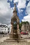 | |||
| F. Parnell, Brae St. (S.) | 56°33′56″N 3°35′05″W | Category C(S) | 5628 | | |||
| 21, 23 Cathedral Street (N.) | 56°33′55″N 3°35′19″W | Category B | 5639 | 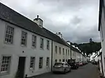 | |||
| 11 The Cross, High Street (N.) | 56°33′57″N 3°35′13″W | Category B | 5648 | | |||
| Gallowhill Lodge To Dunkeld House | 56°34′15″N 3°35′35″W | Category B | 5571 | | |||
| Haughend, Farmhouse | 56°33′51″N 3°34′05″W | Category B | 5580 | | |||
| Dunkeld Bridge Over River Tay | 56°33′50″N 3°35′07″W | Category A | 5620 | 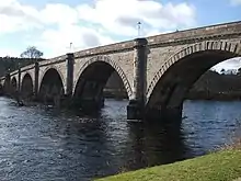 | |||
| Dr. N. Morrison, Bridge Street (W.) | 56°33′56″N 3°35′08″W | Category B | 5623 | | |||
| Atholl Arms Hotel, Bridge St., And Boat Road | 56°33′55″N 3°35′07″W | Category B | 5624 | | |||
| 18, 20 Cathedral Street | 56°33′55″N 3°35′19″W | Category B | 5645 | | |||
| 'The Ell House', The Cross, High Street (W.) | 56°33′56″N 3°35′14″W | Category B | 5646 | | |||
| 'Connacher' The Cross, High Street (W.) | 56°33′56″N 3°35′14″W | Category B | 5647 | | |||
| Dunkeld House, West Grotto | 56°33′56″N 3°36′57″W | Category B | 5573 | | |||
| Ledpettie, Bridge On Disused Section Of Drive To Dunkeld House | 56°35′31″N 3°37′14″W | Category B | 5574 | | |||
| Dowally Church | 56°36′48″N 3°37′43″W | Category B | 5576 | | |||
| Robert Menzies, Atholl St. (W.) | 56°33′57″N 3°35′08″W | Category C(S) | 5592 | | |||
| The Smithy St Ninian's Wynd | 56°33′59″N 3°35′10″W | Category B | 5603 | | |||
| Dunkeld House, Terraced Garden | 56°33′53″N 3°36′17″W | Category C(S) | 5608 | | |||
| Dunkeld Cathedral Property, Brae Street (S) | 56°33′56″N 3°35′06″W | Category C(S) | 5626 | | |||
| J.B. Robertson, Brae St. (S.) | 56°33′56″N 3°35′05″W | Category C(S) | 5627 | | |||
| 1 Cathedral Street (North Side) | 56°33′56″N 3°35′14″W | Category B | 5633 | | |||
| 3 Cathedral Street (N.) | 56°33′56″N 3°35′15″W | Category B | 5634 | | |||
| 9, 11 Cathedral Street (N.) | 56°33′56″N 3°35′17″W | Category B | 5636 | 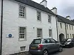 | |||
| 13, 15 Cathedral Street (N.) | 56°33′56″N 3°35′17″W | Category B | 5637 | | |||
| (Dunkeld Restaurant) And Others Atholl Street (W.) | 56°33′57″N 3°35′09″W | Category B | 5590 | | |||
| Masonic Temple, United Lodge Of Dunkeld No. 14-152 (Former Free Church), Boat Road | 56°33′55″N 3°35′06″W | Category C(S) | 5597 | | |||
| 17, 19 High Street (S.) | 56°33′56″N 3°35′11″W | Category B | 83 | | |||
| Guay | 56°37′24″N 3°38′04″W | Category B | 5579 | | |||
| Deancross Old Tollhouse | 56°33′15″N 3°33′31″W | Category B | 5584 | | |||
| Springwells, Brae St. (N.) | 56°33′57″N 3°35′06″W | Category C(S) | 5585 | | |||
| T.I. Stanton To Scottish Gas Board, Atholl Street, (E.) | 56°33′58″N 3°35′07″W | Category C(S) | 5587 | | |||
| Dunkeld House Gardens (Mr Fleming) | 56°34′11″N 3°35′29″W | Category B | 5606 | | |||
| O.S. Mcwilliam & R.A. Gray, Bridge Street (W.) | 56°33′54″N 3°35′08″W | Category C(S) | 5621 | | |||
| Sundial House, Burgess Brae, Off Brae Street | 56°33′55″N 3°35′03″W | Category B | 5630 | | |||
| Dunkeld Cathedral Gates | 56°33′55″N 3°35′20″W | Category B | 5632 | 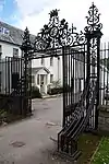 | |||
| 5, 7 Cathedral Street (N.) | 56°33′56″N 3°35′16″W | Category B | 5635 | | |||
| 19 Cathedral Street (N.) | 56°33′55″N 3°35′18″W | Category B | 5638 | | |||
| 8, 10 Cathedral Street | 56°33′55″N 3°35′16″W | Category B | 5643 | | |||
| Lady Charlotte's Cave, Craig-Y-Barns (Marked As Duchess's On O.S. Maps) | 56°34′35″N 3°35′56″W | Category B | 5572 | | |||
| Haughend, Steading | 56°33′50″N 3°34′04″W | Category C(S) | 5581 | | |||
| Eastwood House | 56°33′40″N 3°34′18″W | Category B | 5583 | | |||
| R. Menzies, Atholl St. (W.) | 56°33′57″N 3°35′08″W | Category C(S) | 5589 | | |||
| Dunkeld House, East Grotto. (The Mousetrap) | 56°33′49″N 3°35′44″W | Category B | 5607 | | |||
| 12, 12A The Cross, High St. (N.) | 56°33′57″N 3°35′12″W | Category B | 5610 | | |||
| 14 High Street (N.) (National Trust Property, | 56°33′57″N 3°35′11″W | Category B | 5611 | | |||
| 2 Properties, Burns, Booksellers And City Of Perth Co-Op Soc., Ltd., Bridge Street (W.) | 56°33′55″N 3°35′08″W | Category C(S) | 5622 | | |||
| Brae Street, Hillhead Of Dunkeld, Stable Cottages With Stables, Gatepiers, Gates And Boundary Walls | 56°33′56″N 3°34′50″W | Category C(S) | 43483 | | |||
| Dean's House (Now Rectory House), Cathedral Street (N.) | 56°33′55″N 3°35′19″W | Category B | 5640 | 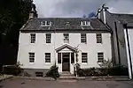 | |||
| Dowally Village, Smith | 56°36′47″N 3°37′43″W | Category C(S) | 5577 | | |||
| Dowally Village, Calvor & Bisset | 56°36′46″N 3°37′43″W | Category C(S) | 5578 | | |||
| Cardney House | 56°35′22″N 3°32′52″W | Category B | 5582 | | |||
| Bruce & Macdonald's Property Atholl Street (W.) | 56°33′59″N 3°35′09″W | Category C(S) | 5593 | | |||
| Former Atholl Inn, And Congregational Church Now Incorporated In Dunkeld Garage, Atholl Street W | 56°34′01″N 3°35′09″W | Category B | 5595 | | |||
| Craigview, Dunkeld | 56°34′04″N 3°35′08″W | Category B | 5604 | | |||
| Brae Street, Hillhead Of Dunkeld, Beechwood House With Terrace Wall And Steps | 56°33′56″N 3°34′58″W | Category B | 5605 | | |||
| 15 High Street (N.) | 56°33′57″N 3°35′10″W | Category B | 5612 | | |||
| Duchess Anne Restaurant (Former Duchess Of Atholl Girl's Industrial School) Cross, Dunkeld | 56°33′57″N 3°35′15″W | Category B | 5617 | | |||
| Scottish Horse Museum, Eastern Part With Pend, High Street (S.) | 56°33′56″N 3°35′12″W | Category C(S) | 5618 | | |||
| Old Post Office To Mckellar, Bridge Street And Mrs. I. Mackintosh, Brae Street (S) | 56°33′55″N 3°35′07″W | Category C(S) | 5625 | | |||
| Ellis's Trustees, Brae St. (S) | 56°33′56″N 3°35′05″W | Category C(S) | 5629 | | |||
| Dunkeld Cathedral | 56°33′54″N 3°35′24″W | Category A | 5631 | 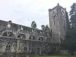 | |||
| 2, 4 Cathedral Street | 56°33′55″N 3°35′14″W | Category B | 5641 | | |||
| Evan Haxton's Property 6 Cathedral Street | 56°33′55″N 3°35′15″W | Category B | 5642 | | |||
| Rotmell Farm | 56°36′17″N 3°37′21″W | Category B | 5575 | | |||
| M. & M. Black, Atholl St. (E.) | 56°33′58″N 3°35′07″W | Category B | 5588 | | |||
| Royal Hotel, Atholl St. (W.) | 56°34′00″N 3°35′09″W | Category B | 5594 | | |||
| Dunkeld Lodge, Atholl Street | 56°34′05″N 3°35′13″W | Category B | 5596 | | |||
| Taybank Hotel, Boat Road | 56°33′58″N 3°35′04″W | Category C(S) | 5599 | | |||
| Perth Arms Hotel, High Street (N.), East Section | 56°33′57″N 3°35′09″W | Category B | 5614 | | |||
| K. Stanley & Sons, High Street (S.) | 56°33′56″N 3°35′09″W | Category B | 5615 | | |||
| Martin And Others (Part Vacant 1963) Brae Street (N) | 56°33′57″N 3°35′07″W | Category C(S) | 84 | |
Key
The scheme for classifying buildings in Scotland is:
- Category A: "buildings of national or international importance, either architectural or historic; or fine, little-altered examples of some particular period, style or building type."[1]
- Category B: "buildings of regional or more than local importance; or major examples of some particular period, style or building type, which may have been altered."[1]
- Category C: "buildings of local importance; lesser examples of any period, style, or building type, as originally constructed or moderately altered; and simple traditional buildings which group well with other listed buildings."[1]
In March 2016 there were 47,288 listed buildings in Scotland. Of these, 8% were Category A, and 50% were Category B, with the remaining 42% being Category C.[2]
Notes
- Sometimes known as OSGB36, the grid reference (where provided) is based on the British national grid reference system used by the Ordnance Survey.
• "Guide to National Grid". Ordnance Survey. Retrieved 2007-12-12.
• "Get-a-map". Ordnance Survey. Retrieved 2007-12-17. - Historic Environment Scotland assign a unique alphanumeric identifier to each designated site in Scotland, for listed buildings this always begins with "LB", for example "LB12345".
References
- All entries, addresses and coordinates are based on data from Historic Scotland. This data falls under the Open Government Licence
- "What is Listing?". Historic Environment Scotland. Retrieved 29 May 2018.
- Scotland's Historic Environment Audit 2016 (PDF). Historic Environment Scotland and the Built Environment Forum Scotland. pp. 15–16. Retrieved 29 May 2018.
This article is issued from Wikipedia. The text is licensed under Creative Commons - Attribution - Sharealike. Additional terms may apply for the media files.