List of listed buildings in Forteviot, Perth and Kinross
List
| Name | Location | Date Listed | Grid Ref. [note 1] | Geo-coordinates | Notes | LB Number [note 2] | Image |
|---|---|---|---|---|---|---|---|
| Parish Church Of Forteviot. Session House | 56°20′25″N 3°32′11″W | Category C(S) | 11053 |  | |||
| Forteviot Square | 56°20′27″N 3°32′08″W | Category A | 11057 | 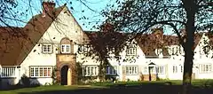 | |||
| Green Of Invermay, House | 56°19′48″N 3°32′11″W | Category C(S) | 11064 | | |||
| Invermay House, West Lodges And Gates | 56°19′27″N 3°32′13″W | Category B | 11067 | | |||
| Invermay House, Game Larder And Ice House | 56°19′41″N 3°31′11″W | Category B | 11072 | | |||
| Old House Of Invermay | 56°19′44″N 3°31′13″W | Category A | 11074 | | |||
| Bridge Over Water Of May, East Of Scott's Bridge | 56°19′24″N 3°29′50″W | Category C(S) | 13731 | | |||
| Pathgreen Farm, Path Of Condie | 56°17′16″N 3°29′54″W | Category B | 11031 | | |||
| Parish Church Of Forteviot | 56°20′25″N 3°32′10″W | Category C(S) | 11052 | 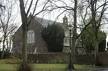 | |||
| Manse Of Forteviot Sundial | 56°20′22″N 3°32′07″W | Category C(S) | 11056 | | |||
| Forteviot Hall | 56°20′25″N 3°32′07″W | Category A | 11058 | 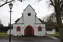 | |||
| The Cottage, Forteviot | 56°20′26″N 3°32′11″W | Category C(S) | 11060 | | |||
| Invermay House. Green Of Invermay Gates | 56°19′48″N 3°32′09″W | Category C(S) | 11066 | | |||
| Invermay House, Estate Wall | 56°19′32″N 3°31′27″W | Category B | 11068 | | |||
| Invermay House Scott's Bridge Over Water Of May | 56°19′45″N 3°31′42″W | Category B | 11070 | | |||
| Invermay House | 56°19′40″N 3°31′14″W | Category A | 11071 | | |||
| Pathstruie Bridge Over Water Of May | 56°17′26″N 3°29′35″W | Category C(S) | 11028 | | |||
| Pathstruie Graveyard | 56°17′19″N 3°29′44″W | Category C(S) | 11030 | | |||
| Invermay House, Gazebo | 56°19′31″N 3°31′36″W | Category C(S) | 11078 | | |||
| Manse Of Forteviot | 56°20′22″N 3°32′05″W | Category B | 11055 | | |||
| Kildinny Steading, West Block Only | 56°20′34″N 3°30′37″W | Category B | 11063 | | |||
| Invermay House Doo'Cot | 56°19′44″N 3°32′04″W | Category B | 11069 | | |||
| K6 Telephone Kiosk In Front Of Workshops, Forteviot Village | 56°20′25″N 3°32′05″W | Category B | 11062 | | |||
| Green Of Invermay Bridge Over Water Of May | 56°19′45″N 3°31′39″W | Category B | 11065 | | |||
| Summerhouse W. Of Invermay House | 56°19′40″N 3°31′18″W | Category C(S) | 11073 | | |||
| Invermay House Stables | 56°19′34″N 3°31′19″W | Category B | 11076 | | |||
| Muckersie Chapel | 56°19′28″N 3°30′00″W | Category C(S) | 11079 | | |||
| Forteviot Hotel (Formerly Forteviot Inn), Including Outbuildings To North And Boundary Walls | 56°20′30″N 3°32′38″W | Category B | 13442 | | |||
| Invermay House Home Farm | 56°19′22″N 3°31′30″W | Category B | 11077 | | |||
| Forteviot Bridge Over River Earn | 56°20′52″N 3°32′52″W | Category B | 11027 | | |||
| Invermay House Dairy | 56°19′45″N 3°31′11″W | Category B | 11075 | | |||
| Whitehill Farm Cottage | 56°16′28″N 3°28′56″W | Category C(S) | 11032 | | |||
| Parish Church Of Forteviot. Churchyard | 56°20′25″N 3°32′10″W | Category C(S) | 11054 | | |||
| Forteviot Old School | 56°20′26″N 3°32′05″W | Category C(S) | 11059 | | |||
| Workshops, Forteviot Village | 56°20′25″N 3°32′06″W | Category B | 11061 | |
Key
The scheme for classifying buildings in Scotland is:
- Category A: "buildings of national or international importance, either architectural or historic; or fine, little-altered examples of some particular period, style or building type."[1]
- Category B: "buildings of regional or more than local importance; or major examples of some particular period, style or building type, which may have been altered."[1]
- Category C: "buildings of local importance; lesser examples of any period, style, or building type, as originally constructed or moderately altered; and simple traditional buildings which group well with other listed buildings."[1]
In March 2016 there were 47,288 listed buildings in Scotland. Of these, 8% were Category A, and 50% were Category B, with the remaining 42% being Category C.[2]
Notes
- Sometimes known as OSGB36, the grid reference (where provided) is based on the British national grid reference system used by the Ordnance Survey.
• "Guide to National Grid". Ordnance Survey. Retrieved 2007-12-12.
• "Get-a-map". Ordnance Survey. Retrieved 2007-12-17. - Historic Environment Scotland assign a unique alphanumeric identifier to each designated site in Scotland, for listed buildings this always begins with "LB", for example "LB12345".
References
- All entries, addresses and coordinates are based on data from Historic Scotland. This data falls under the Open Government Licence
- "What is Listing?". Historic Environment Scotland. Retrieved 29 May 2018.
- Scotland's Historic Environment Audit 2016 (PDF). Historic Environment Scotland and the Built Environment Forum Scotland. pp. 15–16. Retrieved 29 May 2018.
This article is issued from Wikipedia. The text is licensed under Creative Commons - Attribution - Sharealike. Additional terms may apply for the media files.