List of listed buildings in Comrie, Perth and Kinross
List
| Name | Location | Date Listed | Grid Ref. [note 1] | Geo-coordinates | Notes | LB Number [note 2] | Image |
|---|---|---|---|---|---|---|---|
| 20, 22 And Kinfauns, Burrel Street | 56°22′29″N 3°59′37″W | Category C(S) | 6198 |  | |||
| Drummond Street, Mitchell's Building | 56°22′29″N 3°59′11″W | Category C(S) | 6200 | | |||
| Ardvorlich, The Haugh, Bridge Over Ardvorlich Burn | 56°22′53″N 4°12′55″W | Category C(S) | 6212 | | |||
| Ardvorlich, The Haugh, Mcdonald Of Glencoe Stone | 56°22′53″N 4°12′56″W | Category C(S) | 6214 | | |||
| Flowerdale, Dalginross | 56°22′09″N 3°59′01″W | Category C(S) | 5308 | | |||
| Melville Monument Dunmore House | 56°23′14″N 3°59′58″W | Category B | 5321 | | |||
| Assynt, Drummond Street | 56°22′30″N 3°59′15″W | Category C(S) | 5332 | | |||
| War Memorial Institute Bridgend, Dalginross | 56°22′23″N 3°59′14″W | Category C(S) | 5348 | | |||
| Glenpark House, Monument Road | 56°22′33″N 3°59′31″W | Category C(S) | 5364 | | |||
| West End Tearoom, 1 Burrell Street | 56°22′32″N 3°59′32″W | Category C(S) | 5367 | | |||
| Smiddy House, (Wilson) Formerly Occupied By Young And Carson, Dunira Street | 56°22′26″N 3°59′20″W | Category B | 5387 | | |||
| Property Occupied By Brough & Mcpherson, Mitchell & Thomson, And Smith, Also Miss Findlay, Dunira St | 56°22′27″N 3°59′17″W | Category A | 5393 | 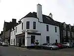 | |||
| Hotel Property, East Side Of Melville Square And Lane | 56°22′28″N 3°59′16″W | Category B | 5395 | | |||
| Hollandbush, Dundas Street | 56°22′29″N 3°59′27″W | Category C(S) | 5404 | | |||
| Benyhone, Dundas Street | 56°22′30″N 3°59′28″W | Category C(S) | 5410 | | |||
| St Fillans, Drummond Arms Hotel With Outbuildings | 56°23′29″N 4°06′54″W | Category C(S) | 5299 | | |||
| Comrie, Cultybraggan Former Cadet Camp, Huts 19 And 20 (Guard's Block) And 44, 45, 46 | 56°21′22″N 3°59′39″W | Category A | 50471 | 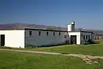 | |||
| Comrie, Cultybraggan Former Cadet Camp, Huts 1-3, 21, 29-39, 47-57 (All Nos Inclusive) | 56°21′24″N 3°59′41″W | Category B | 50472 | 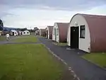 | |||
| Burrell Street And Dundas Street, Comrie And Strowan Parish Church | 56°22′29″N 3°59′33″W | Category C(S) | 6197 | | |||
| Drummond Street, Ancaster Arms Hotel | 56°22′29″N 3°59′10″W | Category C(S) | 6199 | | |||
| Aberuchill Walled Garden | 56°21′54″N 4°02′01″W | Category C(S) | 6209 | | |||
| Craigroyston And Dunalistair, Dalginross | 56°22′10″N 3°59′03″W | Category C(S) | 5303 | | |||
| Laurelbank Dalginross | 56°22′12″N 3°59′03″W | Category C(S) | 5306 | | |||
| Campfield, Dalginross | 56°22′06″N 3°59′06″W | Category C(S) | 5310 | | |||
| Larig Llidh And Dunvegan Camp Road | 56°22′12″N 3°59′06″W | Category C(S) | 5313 | | |||
| Four Hollies Barrack Road | 56°22′14″N 3°58′59″W | Category C(S) | 5315 | | |||
| Property Occupied By James Innes & R W Smith, Drummond Street | 56°22′30″N 3°59′12″W | Category C(S) | 5330 | | |||
| Whin Cottage And Mossbank, Dundas Street | 56°22′31″N 3°59′30″W | Category C(S) | 5361 | | |||
| Westview, Dundas Street | 56°22′32″N 3°59′31″W | Category C(S) | 5362 | | |||
| Cottage Occupied By Miss Carmichael, Monument Road | 56°22′33″N 3°59′32″W | Category C(S) | 5365 | | |||
| Simonside And Ainslie Cottage, Burrell Street | 56°22′31″N 3°59′32″W | Category C(S) | 5370 | | |||
| Public Hall, Burrel Street | 56°22′29″N 3°59′37″W | Category B | 5373 | | |||
| Library And Comrie Dundas Centre, Drummond Street | 56°22′32″N 3°59′07″W | Category C(S) | 5378 | | |||
| 27, 28 Drummond Street | 56°22′31″N 3°59′08″W | Category C(S) | 5379 | | |||
| Comrie Buildings, Drummond Street | 56°22′30″N 3°59′10″W | Category C(S) | 5383 | | |||
| The Cottage And The Cake Shop, Drummond Street | 56°22′30″N 3°59′11″W | Category C(S) | 5384 | | |||
| Old Parish Church Churchyard | 56°22′26″N 3°59′17″W | Category B | 5386 | | |||
| Glenorchy House Dunira Street | 56°22′27″N 3°59′18″W | Category C(S) | 5388 | | |||
| St Kessac's Dunira Street | 56°22′27″N 3°59′18″W | Category B | 5389 | | |||
| Maurshel Dunira Street | 56°22′27″N 3°59′19″W | Category C(S) | 5390 | | |||
| Dunearn Corner Of Dundas Street And Dunira Street | 56°22′26″N 3°59′21″W | Category C(S) | 5400 | | |||
| Cairndhu And Carradale, Dundas Street | 56°22′27″N 3°59′23″W | Category C(S) | 5402 | | |||
| Bridge Of Ross Over River Earn | 56°22′29″N 3°59′49″W | Category B | 5289 | | |||
| House Of Ross | 56°22′18″N 4°00′24″W | Category B | 5290 | | |||
| Mill Of Ross | 56°22′19″N 4°00′37″W | Category C(S) | 5291 | | |||
| Rosewell And Hafton, Dalginross | 56°22′13″N 3°59′05″W | Category C(S) | 5300 | | |||
| Ardvorlich Stables And Farm, Including Bridge To West | 56°22′44″N 4°12′58″W | Category C(S) | 50368 | | |||
| St Fillans, Wellandura Including Outbuildings And Boundary Walls | 56°23′38″N 4°07′17″W | Category C(S) | 50391 | | |||
| Ivy Cottage Dalginross | 56°22′11″N 3°59′02″W | Category B | 5307 | | |||
| Drummonie Cottage Gowanlea Road | 56°22′09″N 3°58′54″W | Category C(S) | 5317 | | |||
| Tullichettle (Former Manse Of Comrie) | 56°21′37″N 3°59′20″W | Category B | 5322 | | |||
| Nos 1 And 2 Glasdale | 56°22′31″N 3°59′51″W | Category C(S) | 5324 | | |||
| Malloch Buildings, Drummond Street | 56°22′30″N 3°59′12″W | Category C(S) | 5329 | | |||
| Dundurn And Isdaile, Drummond Street | 56°22′31″N 3°59′06″W | Category C(S) | 5336 | | |||
| St Kessog's Masonic Lodge Hall, Drummond Street | 56°22′31″N 3°59′07″W | Category C(S) | 5338 | | |||
| Chiltern, Dalginross | 56°22′17″N 3°59′08″W | Category C(S) | 5353 | | |||
| Kintyre, Dalginross | 56°22′16″N 3°59′08″W | Category C(S) | 5354 | | |||
| The Neuk' Dalginross | 56°22′16″N 3°59′08″W | Category C(S) | 5355 | | |||
| Woodview, Burrell Street | 56°22′31″N 3°59′34″W | Category C(S) | 5368 | | |||
| Kilgour Cottage Burrell Street | 56°22′31″N 3°59′34″W | Category C(S) | 5369 | | |||
| Morrison's Buildings, Drummond Street | 56°22′32″N 3°59′07″W | Category C(S) | 5377 | | |||
| Craiglea, Drummond Street | 56°22′32″N 3°59′08″W | Category C(S) | 5380 | | |||
| Dundas House With Shops Occupied By J R M Mcdougall & Son And R Kay, Corner Of Dunira Street And Dundas Street | 56°22′26″N 3°59′20″W | Category C(S) | 5392 | | |||
| Schoolhouse, Dundas Street | 56°22′26″N 3°59′22″W | Category B | 5401 | | |||
| Former United Free Church And Kirk Cottage Dundas Street | 56°22′28″N 3°59′22″W | Category C(S) | 5405 | | |||
| Hillcote And House, Occupied By Mrs Smith, Glasdale | 56°22′31″N 4°00′02″W | Category C(S) | 5288 | | |||
| The Cottage, Dundas Street | 56°22′32″N 3°59′30″W | Category C(S) | 76 | | |||
| Drummond Street, Rohrbach, Stalker And Sorley's Property | 56°22′28″N 3°59′14″W | Category C(S) | 6205 | | |||
| Ardvorlich House | 56°22′45″N 4°13′05″W | Category B | 6211 | | |||
| Greystones And Yean House Barrack Road | 56°22′14″N 3°59′02″W | Category C(S) | 5314 | | |||
| Drumearn (Including Walled Garden And Coach House And Stable Block). The Ross Comrie | 56°22′24″N 4°00′03″W | Category B | 5318 | | |||
| Yen-U House Glasdale | 56°22′31″N 3°59′55″W | Category C(S) | 5327 | | |||
| Ballacraine, Drummond Street | 56°22′29″N 3°59′12″W | Category C(S) | 5331 | | |||
| Arden House And Shop (D Comrie & Son) Drummond Street | 56°22′28″N 3°59′16″W | Category B | 5333 | | |||
| Mansefield, Manse Lane, Off Drummond Street | 56°22′29″N 3°59′05″W | Category C(S) | 5337 | | |||
| 16 Drummond Street | 56°22′30″N 3°59′08″W | Category C(S) | 5341 | | |||
| 18 Drummond Street | 56°22′30″N 3°59′09″W | Category C(S) | 5342 | | |||
| 7 Drummond Street | 56°22′33″N 3°59′05″W | Category C(S) | 5376 | | |||
| Old Parish Church, (Now Comrie Youth Centre Flambeaux Club) Dunira St | 56°22′26″N 3°59′19″W | Category A | 5385 | | |||
| Dunfallandy Glasdale | 56°22′31″N 4°00′02″W | Category C(S) | 5287 | | |||
| Mill Of Ross Sawmill | 56°22′20″N 4°00′39″W | Category C(S) | 5293 | | |||
| Dunmore Cottage | 56°23′23″N 4°03′22″W | Category B | 5297 | | |||
| Ruchilbank, Dalginross | 56°22′11″N 3°59′03″W | Category C(S) | 5301 | | |||
| Dalginross Bridge Over River Earn | 56°22′25″N 3°59′14″W | Category C(S) | 75 | | |||
| St Fillans, Ard Choille Including Cottage, Boundary Walls And Gatepiers | 56°23′34″N 4°07′06″W | Category C(S) | 50378 | | |||
| St Fillans, Former Railway Station With Signal Box, Waiting Room And Retaining Walls | 56°23′38″N 4°06′29″W | Category B | 50380 | 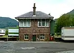 | |||
| St Fillans, Fortrenn With Retaining Wall And Summer House | 56°23′45″N 4°07′31″W | Category C(S) | 50381 | | |||
| Dunira Sawmill Including Mill Wheel, Weir, Sluice And Outbuildings | 56°22′57″N 4°03′26″W | Category B | 6683 | | |||
| St Fillans, The Old Church, Former Church Of The Holy Spirit Including Steps And Boundary Wall | 56°23′27″N 4°06′44″W | Category C(S) | 6227 | | |||
| Lyne Cottage, Dalginross | 56°22′08″N 3°59′03″W | Category C(S) | 5304 | | |||
| Comrie House | 56°22′41″N 3°59′18″W | Category C(S) | 5345 | | |||
| Comrie Post Office Buildings (Mcnaughton) Bridge Street | 56°22′27″N 3°59′14″W | Category C(S) | 5346 | | |||
| Earnside (Peter W Mills) Bridge Street | 56°22′26″N 3°59′14″W | Category C(S) | 5347 | | |||
| Victoria, Dalginross | 56°22′21″N 3°59′12″W | Category C(S) | 5350 | | |||
| Seton Cottage, Dalginross | 56°22′20″N 3°59′12″W | Category C(S) | 5351 | | |||
| Lifra, Dundas Street | 56°22′31″N 3°59′29″W | Category C(S) | 5360 | | |||
| 10 Dundas Street | 56°22′29″N 3°59′27″W | Category C(S) | 5403 | | |||
| Mill Of Ross Miller's House | 56°22′20″N 4°00′38″W | Category C(S) | 5292 | | |||
| Dalchonzie Mill Bridge Over River Earn | 56°22′56″N 4°02′30″W | Category C(S) | 5294 | | |||
| Aberuchill (Original Tower House And Wing To East Only) | 56°21′58″N 4°02′00″W | Category A | 5296 | | |||
| Hope Cottage (Former Stables Of The Hollies, Barrack Road) | 56°22′15″N 3°58′58″W | Category C(S) | 74 | | |||
| Ardvorlich Estate, March Cottage | 56°22′44″N 4°14′21″W | Category C(S) | 50366 | | |||
| Ardvorlich, Walled Garden Including Glasshouses And Sundial | 56°22′46″N 4°12′50″W | Category C(S) | 50369 | | |||
| Balmenoch, Dundas Street | 56°22′31″N 3°59′29″W | Category C(S) | 6196 | | |||
| Drummond Street, Rumours | 56°22′28″N 3°59′13″W | Category C(S) | 6203 | | |||
| Mid Square, Dalginross | 56°22′13″N 3°59′04″W | Category C(S) | 5305 | | |||
| Bracklinn, Upper Square | 56°22′03″N 3°58′55″W | Category C(S) | 5311 | | |||
| Auchenross, The Ross Comrie | 56°22′16″N 3°59′52″W | Category B | 5319 | | |||
| Oakbank The Ross | 56°22′22″N 3°59′51″W | Category C(S) | 5320 | | |||
| Lilac Cottage Glasdale | 56°22′31″N 3°59′55″W | Category C(S) | 5326 | | |||
| 4 Drummond Street | 56°22′32″N 3°59′05″W | Category C(S) | 5334 | | |||
| Nos 1 And 2 Bridgend Dalginross | 56°22′23″N 3°59′13″W | Category C(S) | 5349 | | |||
| Benhalton, Dundas Street/Monument Road | 56°22′32″N 3°59′31″W | Category C(S) | 5363 | | |||
| Glen Cottage, Monument Road | 56°22′32″N 3°59′34″W | Category C(S) | 5366 | | |||
| Atholl Bank, Burrell Street | 56°22′30″N 3°59′34″W | Category C(S) | 5372 | | |||
| Gould Cottage, Drummond Street | 56°22′31″N 3°59′10″W | Category C(S) | 5382 | | |||
| Knocknairn Drummond Street | 56°22′27″N 3°59′20″W | Category C(S) | 5391 | | |||
| Royal Hotel Melville Square. Including Former Stabling | 56°22′28″N 3°59′17″W | Category B | 5394 | | |||
| Glenearn, Dundas Street | 56°22′29″N 3°59′25″W | Category B | 5407 | | |||
| Craigard, Dundas Street | 56°22′30″N 3°59′26″W | Category C(S) | 5408 | | |||
| Morven, Dundas Street | 56°22′30″N 3°59′27″W | Category C(S) | 5409 | | |||
| Dalchonzie House | 56°22′41″N 4°02′14″W | Category B | 5295 | | |||
| St Leonards, Dalginross | 56°22′11″N 3°59′03″W | Category C(S) | 5302 | | |||
| St Fillans, Bridge Over The River Earn | 56°23′30″N 4°06′13″W | Category B | 59 | | |||
| Drummond Estate, Glen Artney Church (Church Of Scotland) | 56°19′10″N 4°05′02″W | Category C(S) | 48624 | | |||
| St Fillans, Allt An Fhionn, Former Railway Viaduct | 56°23′53″N 4°08′15″W | Category B | 50375 | | |||
| St Fillans, Dundurn Parish Church (Church Of Scotland) | 56°23′30″N 4°07′01″W | Category C(S) | 50379 | | |||
| Drummond Street, Foster's Property | 56°22′27″N 3°59′15″W | Category C(S) | 6707 | | |||
| Drummond Street, Richard's Property | 56°22′29″N 3°59′12″W | Category C(S) | 6201 | | |||
| Drummond Street, Benview And Shop (Boyd) | 56°22′28″N 3°59′14″W | Category C(S) | 6206 | | |||
| Drummond Street And Bridge Street, Royal Bank Of Scotland | 56°22′27″N 3°59′15″W | Category C(S) | 6208 | | |||
| Invergeldie Bridge Over Invergeldie Burn | 56°25′17″N 4°02′29″W | Category B | 6215 | | |||
| Aberuchil Castle Burial Ground, Strageath's Graves | 56°22′09″N 4°02′13″W | Category C(S) | 6217 | | |||
| Victoria Cottage, Glasdale | 56°22′31″N 3°59′54″W | Category C(S) | 5325 | | |||
| 12 Drummond Street | 56°22′31″N 3°59′07″W | Category C(S) | 5339 | | |||
| Millside, Nurse's Lane | 56°22′36″N 3°59′08″W | Category B | 5344 | | |||
| Craigbeg, Dalginross | 56°22′20″N 3°59′11″W | Category C(S) | 5352 | | |||
| Wellpark, Dalginross | 56°22′15″N 3°59′08″W | Category C(S) | 5356 | | |||
| Benyhone Cottage, 21 Dundas Street | 56°22′31″N 3°59′28″W | Category B | 5358 | | |||
| Thornlea, Burrell Street | 56°22′31″N 3°59′33″W | Category C(S) | 5371 | | |||
| Property Occupied By Mckeith, Drummond Street | 56°22′31″N 3°59′09″W | Category C(S) | 5381 | | |||
| Comrie Bookshop Melville Lane | 56°22′29″N 3°59′17″W | Category C(S) | 5397 | | |||
| Comrie Primary School | 56°22′32″N 3°59′23″W | Category B | 5399 | | |||
| Station Road, St Serf's Episcopal Church Including Gates | 56°22′35″N 3°58′59″W | Category C(S) | 48625 | | |||
| Balimeanach Farm | 56°22′46″N 4°12′18″W | Category C(S) | 50370 | | |||
| Drummond Street, Lesley Macdougal's Property | 56°22′28″N 3°59′12″W | Category C(S) | 6202 | | |||
| Drummond Street, Commercial Lane, Former Secession Church | 56°22′27″N 3°59′13″W | Category C(S) | 6204 | | |||
| Drummond Street, F Hamilton's Property | 56°22′28″N 3°59′14″W | Category C(S) | 6207 | | |||
| Ardvorlich House, North Gate | 56°22′46″N 4°13′16″W | Category C(S) | 6213 | | |||
| Heath Cottages Dalginross | 56°22′09″N 3°59′01″W | Category C(S) | 5309 | | |||
| Comrie Cottage Upper Square Dalginross | 56°22′01″N 3°58′54″W | Category C(S) | 5312 | | |||
| Ruchill House Barrack Road | 56°22′17″N 3°58′49″W | Category C(S) | 5316 | | |||
| Earthquake House The Ross, Comrie | 56°22′19″N 4°00′03″W | Category C(S) | 5323 | | |||
| Earn Cottage Glasdale | 56°22′30″N 3°59′57″W | Category C(S) | 5328 | | |||
| 6 Drummond Street | 56°22′31″N 3°59′05″W | Category C(S) | 5335 | | |||
| 14 Drummond Street | 56°22′31″N 3°59′08″W | Category C(S) | 5340 | | |||
| 20 Drummond Street | 56°22′30″N 3°59′09″W | Category C(S) | 5343 | | |||
| Earnhope Dalginross | 56°22′16″N 3°59′05″W | Category C(S) | 5357 | | |||
| Aberuchill View Dundas Street | 56°22′31″N 3°59′28″W | Category C(S) | 5359 | | |||
| Lednock Cottage, Drummond Street | 56°22′34″N 3°59′03″W | Category C(S) | 5374 | | |||
| Lednock Bank, Drummond Street | 56°22′34″N 3°59′03″W | Category C(S) | 5375 | | |||
| Sheds, East Side Of Melville Lane, Off Drummond Street (Hotel And Comrie Bookshop Property) | 56°22′29″N 3°59′16″W | Category C(S) | 5396 | | |||
| Blinkbonny, Melville Lane | 56°22′30″N 3°59′17″W | Category C(S) | 5398 | | |||
| Lynton, Dundas Street | 56°22′29″N 3°59′25″W | Category B | 5406 | | |||
| St Fillan's Chapel And Burial Ground | 56°23′12″N 4°06′04″W | Category B | 5298 | | |||
| St Fillans, Rose Cottage Including Boundary Walls And Gatepiers | 56°23′36″N 4°07′13″W | Category C(S) | 48094 | | |||
| Loch Earn, Memorial Stone To Major James Stewart | 56°22′53″N 4°12′56″W | Category C(S) | 50373 | |
Key
The scheme for classifying buildings in Scotland is:
- Category A: "buildings of national or international importance, either architectural or historic; or fine, little-altered examples of some particular period, style or building type."[1]
- Category B: "buildings of regional or more than local importance; or major examples of some particular period, style or building type, which may have been altered."[1]
- Category C: "buildings of local importance; lesser examples of any period, style, or building type, as originally constructed or moderately altered; and simple traditional buildings which group well with other listed buildings."[1]
In March 2016 there were 47,288 listed buildings in Scotland. Of these, 8% were Category A, and 50% were Category B, with the remaining 42% being Category C.[2]
Notes
- Sometimes known as OSGB36, the grid reference (where provided) is based on the British national grid reference system used by the Ordnance Survey.
• "Guide to National Grid". Ordnance Survey. Retrieved 2007-12-12.
• "Get-a-map". Ordnance Survey. Retrieved 2007-12-17. - Historic Environment Scotland assign a unique alphanumeric identifier to each designated site in Scotland, for listed buildings this always begins with "LB", for example "LB12345".
References
- All entries, addresses and coordinates are based on data from Historic Scotland. This data falls under the Open Government Licence
- "What is Listing?". Historic Environment Scotland. Retrieved 29 May 2018.
- Scotland's Historic Environment Audit 2016 (PDF). Historic Environment Scotland and the Built Environment Forum Scotland. pp. 15–16. Retrieved 29 May 2018.
This article is issued from Wikipedia. The text is licensed under Creative Commons - Attribution - Sharealike. Additional terms may apply for the media files.