Litchfield Municipality
The Litchfield Council is a local government area of the Northern Territory of Australia on the eastern and southeastern outskirts of the Darwin-Palmerston urban area. The municipality covers an area of 2,903 square kilometres (1,120.9 sq mi), and was created by the Northern Territory government on 6 September 1985.
| Litchfield Council Northern Territory | |||||||||||||||
|---|---|---|---|---|---|---|---|---|---|---|---|---|---|---|---|
 | |||||||||||||||
| Population | 25,598 (2018)[1] | ||||||||||||||
| • Density | 8.8178/km2 (22.838/sq mi) | ||||||||||||||
| Established | 1985 | ||||||||||||||
| Area | 2,903 km2 (1,120.9 sq mi)[1] | ||||||||||||||
| Council seat | Freds Pass | ||||||||||||||
| Region | Outer Metropolitan Darwin | ||||||||||||||
| Federal Division(s) | Lingiari | ||||||||||||||
| Website | Litchfield Council | ||||||||||||||
| |||||||||||||||
| Footnotes | Adjoining LGAs[2] | ||||||||||||||
Geography
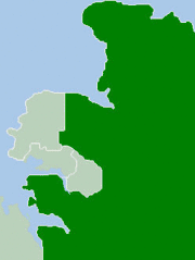
The Litchfield Municipality is bounded by the Adelaide River to the east, Van Diemen Gulf and the Coomalie Shire in the south and the City of Darwin and City of Palmerston to the northwest. The Stuart and Arnhem Highways run through the Litchfield Municipality. Most of the Municipality is rural or rural-residential in character.
History
The original inhabitants of the Litchfield area were the Larrakia, Woolner and Djowei Aboriginal people. The arrival of European settlers dates from 1864. Litchfield is named after Frederick Henry Litchfield who with William Patrick Auld was a member of an early survey and settlement party and who explored areas of the Northern Territory from Escape Cliffs in Van Diemen Gulf to the Daly River. Some growth took place during the 1870s and 1880s, after the construction of the Overland Telegraph Line. There was more substantial growth during the post-war years, especially during the 1970s.
The Litchfield Shire was proclaimed by an Act of the NT Parliament on 6 September 1985. On 7 December 1985 an election was held to elect the first Council composed of a Shire President and four Councillors each representing a ward – North, South, East and Central.
This first elected body formulated a series of objectives under which Council was to operate. The objectives were based upon the provision of services in what is traditionally known as the 3R's ( Roads, Rubbish and Recreation) and on the principle of contracting out the provision of these services. The level of services under these functions were to be commensurate with a philosophy of low rates.
In 2008 Litchfield Shire removed Shire in its name due to the new Local Government Act 2008, which saw changes in the structure of local government across the Northern Territory.
On 1 July 2008 Litchfield Council's responsibilities also included management of the Thorak Regional Cemetery.
In 2015 the entire Litchfield council and mayor Allan McKay was sacked by then NT Local Government Minister Bess Price amid allegations of bullying, misuse of funds and budget blow-outs.[3] Allan McKay while serving as mayor had previously received a no-entry order and had been banned from council property after being accused of harassing council staff and fellow councilors.[4]
In the subsequent election in November 2015, former local primary school principle Maree Bredhauer was elected as Mayor out of a field of eight candidates.[5]
Localities
Localities within the boundary of the Municipality include:[6]
| Outer Darwin | Western Rural | Eastern Rural |
|---|---|---|
The majority of localities within the Municipality were gazetted on 29 October 1997. Herbert was gazetted on 15 July 1998 while Channel Island and Wickham were gazetted on 21 April 2004. On 4 April 2007, the localities of Glyde Point, Gunn Point, Koolpinyah, Shoal Bay, Weddell and Wak Wak were created and the boundaries of the localities of Blackmore and Murrumujuk were amended.[7][8][9][10]
Population
| Year | Pop. | ±% |
|---|---|---|
| 1986 | 7,410 | — |
| 1991 | 9,746 | +31.5% |
| 1996 | 13,858 | +42.2% |
| 2001 | 16,086 | +16.1% |
| 2006 | 17,461 | +8.5% |
| 2011 | 18,994 | +8.8% |
Council presidents
- John Maley (1985–1996)
- Gerry Wood (1996–2001)
- Mary Walshe (2001–2012)
Mayor
- Alan McKay (2012 – 2015)
- Maree Bredhauer (2015 - current)[11]
References
- "3218.0 – Regional Population Growth, Australia, 2017-18: Population Estimates by Local Government Area (ASGS 2018), 2017 to 2018". Australian Bureau of Statistics. Australian Bureau of Statistics. 27 March 2019. Retrieved 25 October 2019. Estimated resident population, 30 June 2018.
- "Litchfield Municipality Localities (map)" (PDF). Northern Territory Government. 29 October 1997. Retrieved 16 May 2019.
- "'Dysfunctional' Litchfield Council sacked by NT Government". 12 October 2015.
- "'Exiled' mayor allowed into council building for meeting". 22 January 2015.
- https://www.litchfield.nt.gov.au/sites/default/files/PDFs/Governance/Declaration%20of%20Poll%20-%20Signed.pdf
- "Archived copy". Archived from the original on 5 October 2009. Retrieved 8 August 2009.CS1 maint: archived copy as title (link)
- "Place Names Register Extract for Herbert (locality)". NT Place Names Register. Northern Territory Government. Retrieved 13 June 2019.
- Palmer, M.J. (29 October 1997). "Place Names Act, NAMING OF PUBLIC PLACE" (PDF). Northern Territory Government Gazette. Northern Territory Government. pp. 7–9. Retrieved 13 June 2019.
the localities shown on the plan appearing in the schedule be named Acacia Hills, Bees Creek, Berry Springs, Black Jungle, Blackmore, Coolalinga, Daly, Darwin River, Fly Creek, Freds Pass, Girraween, Holtze, Howard Springs, Hughes, Humpty Doo, Knuckey Lagoon, Lambells Lagoon, Livingstone, Lloyd Creek, Manton, McMinns Lagoon, Micket Creek, Middle Point, Noonamah, Southport, Tumbling Waters and Virginia
- Burns, Christopher. B. (21 April 2004). "Place Names Act, Naming of Public Place ("East Arm localities")" (PDF). The Northern Territory Government Gazette. Northern Territory Government. p. 7. Retrieved 13 June 2019.
- "Litchfield Council (sic)". Place Names Committee. Northern Territory Government. Retrieved 13 June 2019.
- https://www.litchfield.nt.gov.au/sites/default/files/PDFs/Governance/Declaration%20of%20Poll%20-%20Signed.pdf