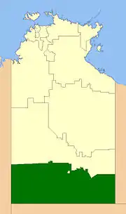
MacDonnell Region
The MacDonnell Regional Council is a local government area of the Northern Territory, Australia. The region covers an area of 268,329 square kilometres (103,602 square miles) and had an estimated population of 6,863 people in June 2018.[1]
| MacDonnell Regional Council Northern Territory | |||||||||||||||
|---|---|---|---|---|---|---|---|---|---|---|---|---|---|---|---|
 | |||||||||||||||
| Coordinates | 26.5931°S 118.4911°E | ||||||||||||||
| Population | 6,863 (2018)[1] | ||||||||||||||
| • Density | 0.0255768/km2 (0.066244/sq mi) | ||||||||||||||
| Established | 2008 | ||||||||||||||
| Area | 268,329 km2 (103,602.4 sq mi)[1] | ||||||||||||||
| Mayor | Sid Anderson | ||||||||||||||
| Council seat | Alice Springs (not part of council) | ||||||||||||||
| Region | Alice Springs Region | ||||||||||||||
| Territory electorate(s) | |||||||||||||||
| Federal Division(s) | Lingiari | ||||||||||||||
| Website | MacDonnell Regional Council | ||||||||||||||
| |||||||||||||||
Geography
MacDonnell Regional Council occupies the south of the Northern Territory and is the only LGA that borders with South Australia, specifically with Anangu Pitjantjatjara Yankunytjatjara in the southwest and the Pastoral Unincorporated Area in the southeast.
Alice Springs and Yulara are enclaves within the LGA.
History
In October 2006 the Northern Territory Government announced the reform of local government areas. The intention of the reform was to improve and expand the delivery of services to towns and communities across the Northern Territory by establishing eleven new shires. The MacDonnell Shire Council was created on 1 July 2008 as were the remaining ten shires. On 1 January 2014, it was renamed MacDonnell Region.[2]
Elections of shire councillors were held on 25 October 2008. The current President (Mayor) of the MacDonnell Region is Sid Anderson.
Community Government Councils merged into the MacDonnell Shire as did a large area of unincorporated area. The existing Community Government Councils and one regional council were:
- Amoonguna Community Incorporated[3]
- Aputula Housing Association Incorporated
- Areyonga Community Incorporated
- Ikuntji Community Council Incorporated[3]
- Imanpa Community Incorporated[3]
- Kaltukatjara Community Council Aboriginal Corporation
- Ntaria Council Incorporated[3]
- Papunya Community Council Incorporated[3]
- Walungurru Council Aboriginal Corporation
- Wallace Rockhole Community Government Council
- Ltyentye Apurte Community Government Council
- Tapatjatjaka Community Government Council
- Watiyawanu Community Government Council
Wards
The MacDonnell Regional Council is divided into 4 wards, which are governed by 12 councillors:
- Rodinga (4)
- Ljirapinta (2)
- Luritja Pintubi (4)
- Iyarrka (3)
Towns by ward
The following towns fall within the four wards as follows:,[4] with population figures as of 30 June 2007:[5]
- Iyarrka
- Docker River (Kaltukatjara) (311)
- Imanpa (217)
- Areyonga (Utju) (245)
- Ljirapinta
- Hermannsburg (Ntaria) (600)
- Wallace Rockhole (Ulana) (107)
- Luritja Pintubi
- Haasts Bluff (Ikuntji) (165)
- Kintore (Walungurru) (350)
- Mount Liebig (Watijawanu) (252)
- Papunya (Warumpi) (342)
- Rodinga
- Amoonguna (362)
- Aputula (Finke) (240)
- Santa Teresa (Ltyentye Apurte) (652 in 2006)
- Titjikala (Tapatjatjaka) (265)
References
- "3218.0 – Regional Population Growth, Australia, 2017-18: Population Estimates by Local Government Area (ASGS 2018), 2017 to 2018". Australian Bureau of Statistics. Australian Bureau of Statistics. 27 March 2019. Retrieved 25 October 2019. Estimated resident population, 30 June 2018.
- TOLLNER, DAVID WILLIAM (18 December 2013). "Local Government Act CHANGES TO LOCAL GOVERNMENT AREAS AND COUNCILS" (PDF). Northern Territory Government Gazette. Northern Territory Government. p. 3. Retrieved 26 April 2019.
with effect from 1 January 2014:
- Knight, D.R. (30 June 2008). "Local Government Grants Commission Act, Revocation of declaration of local governing bodies" (PDF). Northern Territory Government. p. 1. Retrieved 8 April 2020.
- "Archived copy". Archived from the original on 11 July 2009. Retrieved 29 July 2009.CS1 maint: archived copy as title (link)
