Llogara Pass
The Llogara Pass (Albanian: Qafa e Llogarasë; Greek: Στενό Λογαρά) is a high mountain pass within the Ceraunian Mountains along the Albanian Riviera. It connects the Dukat Valley in the north with Himarë in the south. Orikum is the nearest city on the northern side of the pass and the village of Dhërmi in the south.
| Llogara Pass | |
|---|---|
IUCN category II (national park)[1] | |
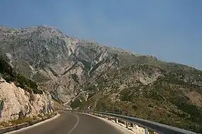 View of Maja e Çikës from the SH8 | |
| Location | Orikum and Vlorë, Albania |
| Coordinates | 40°11′55″N 19°35′30″E |
| Established | 1966[2] |
The Llogara Pass is also part of the Llogara National Park, which spans an area of 10.1 km2 (3.9 sq mi).[3][4] In November 1912, during the Himara revolt a Greek unit was positioned on the Llogara in order to defend the region of Himara from Ottoman-Albanian attacks from the direction of Vlorë.[5]
See also
- Llogara National Park
- Geography of Albania
- Mountain passes of Albania
References
- "Llogara". Protected Planet. Retrieved 31 December 2018.
- Lonely Planet Southeastern Europe (Lonely Planet, Marika McAdam, James Bainbridge, Mark Baker, Peter Dragicevich, Mark Elliott, Tom Masters, Craig McLachlan, Anja Mutic, Tamara Sheward ed.). Lonely Planet, 2013. September 2013. ISBN 9781743217900.
- "Geotourism development in the protected area LlogaraKaraburun" (PDF). geotur.tuke.sk. p. 1.
- "The assessment and project idea to improve landscape of the National Park of "Llogara"". researchgate.net.
- ...], Hellenic Army General Staff, Army History Directorate. [Ed. committee: Dimitrios Gedeon (1998). A concise history of the Balkan Wars, 1912-1913 (1.udg. ed.). Athens: Hellenic Army General Staff. ISBN 9607897072. Retrieved 6 September 2016.CS1 maint: numeric names: authors list (link)

This article is issued from Wikipedia. The text is licensed under Creative Commons - Attribution - Sharealike. Additional terms may apply for the media files.