Lockport Heights, Louisiana
Lockport Heights is an unincorporated community and census-designated place in Lafourche Parish, Louisiana, United States. Its population was 1,286 as of the 2010 census.[1] Louisiana Highway 1 passes through the community.
Lockport Heights, Louisiana | |
|---|---|
 Lockport Heights  Lockport Heights | |
| Coordinates: 29°39′02″N 90°32′47″W | |
| Country | United States |
| State | Louisiana |
| Parish | Lafourche |
| Area | |
| • Total | 1.339 sq mi (3.47 km2) |
| • Land | 1.309 sq mi (3.39 km2) |
| • Water | 0.030 sq mi (0.08 km2) |
| Elevation | 3 ft (0.9 m) |
| Population | |
| • Total | 1,286 |
| • Density | 960/sq mi (370/km2) |
| Time zone | UTC-6 (Central (CST)) |
| • Summer (DST) | UTC-5 (CDT) |
| Area code(s) | 985 |
| GNIS feature ID | 543408[2] |
Geography
According to the U.S. Census Bureau, the community has an area of 1.339 square miles (3.47 km2); 1.309 square miles (3.39 km2) of its area is land, and 0.030 square miles (0.078 km2) is water.[1]
References
- "2010 Census Gazetteer Files - Places: Louisiana". U.S. Census Bureau. Retrieved January 16, 2017.
- "Lockport Heights". Geographic Names Information System. United States Geological Survey.
Municipalities and communities of Lafourche Parish, Louisiana, United States | ||
|---|---|---|
| City | 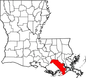 | |
| Towns | ||
| CDPs | ||
| Other Unincorporated communities | ||
| Footnotes | ‡This populated place also has portions in an adjacent parish or parishes | |
| ||
This article is issued from Wikipedia. The text is licensed under Creative Commons - Attribution - Sharealike. Additional terms may apply for the media files.