List of parishes in Louisiana
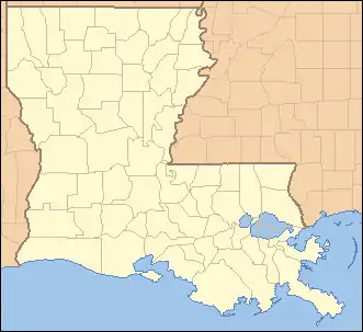
The U.S. state of Louisiana is divided into 64 parishes (French: paroisses, Spanish: parroquias) in the same manner that Alaska is divided into boroughs, and 48 other states are divided into counties.
| Parishes of Louisiana | |
|---|---|
| Category | Second-level administrative division |
| Location | State of Louisiana |
| Number | 64 Parishes |
| Populations | Greatest: 440,059 (East Baton Rouge Parish) Least: 4,334 (Tensas Parish) Average: 72,637 |
| Areas | Largest: 2,429 square miles (6,290 km2) (Plaquemines Parish) Smallest: 203 square miles (530 km2) (West Baton Rouge Parish) Average: 781 square miles (2,020 km2) |
| Government | Parish government |
| Subdivisions | cities, Towns, Census designated place, Unincorporated area |
 |
|---|
| This article is part of a series on the politics and government of Louisiana |
|
|
|
|
|
See also: List of United States Senators from Louisiana
|
|
Thirty-eight parishes are governed by a council called a Police Jury. The remaining 26 have various other forms of government, including: council-president, council-manager, parish commission, and consolidated parish/city.[1]
History
Louisiana was formed from French and Spanish colonies, which were both officially Roman Catholic. Local colonial government was based upon parishes, as the local ecclesiastical division.
Following the Louisiana Purchase in 1803, the territorial legislative council divided the Territory of Orleans (the predecessor of Louisiana state) into 12 counties. The borders of these counties were poorly defined, but they roughly coincided with the colonial parishes, and hence used the same names.[2]
On March 31, 1807, the territorial legislature created 19 parishes without abolishing the old counties (which term continued to exist until 1845). In 1811, a constitutional convention was held to prepare for Louisiana's admission into the Union.[3] This organized the state into seven judicial districts, each consisting of groups of parishes. In 1816, the first official map of the state used the term parish, as did the 1845 constitution. Since then, the official term for Louisiana's primary civil divisions has been parishes.
The 19 original parishes were joined by Catahoula Parish in 1808, and in 1810 four additional parishes were created from the formerly Spanish West Florida territory.
By April 1812, Attakapas Parish became St. Martin Parish and St. Mary Parish. On April 30, the state was admitted to the Union with 25 parishes.
By 1820, Washington Parish was added, and Feliciana Parish split into West and East in 1824. The next year, Jefferson Parish was carved from Orleans Parish. By 1830, Claiborne Parish was created, and the old Warren Parish was mostly absorbed into Ouachita Parish, only to return as Carroll Parish a few years later.
In 1838, Caddo Parish was created from Natchitoches, as were Madison and Caldwell parishes in the east. In 1839, Union Parish was formed from Ouachita, and Calcasieu was formed from St. Landry in 1840.
Five parishes were created in 1843: Bossier, DeSoto, Franklin, Sabine, and Tensas. Morehouse Parish and Vermilion Parish were formed from Ouachita and Lafayette parishes, respectively, in 1844. The next year, Jackson Parish was formed, the old county units were abandoned, and the units were officially referred to as "parishes". In 1848, Bienville Parish was formed from Claiborne Parish. In 1852, Winn Parish was formed, while parishes further south added and lost land.
In 1853, Lafourche Interior Parish was renamed to Lafourche Parish. During Reconstruction, state government created a number of new parishes, with the first being Iberia and Richland parishes. Plans for creating a parish like Iberia from St. Martin and St. Mary parishes had dated from the 1840s. Tangipahoa and Grant parishes followed in 1869. In 1870, the fifth Reconstruction parish, Cameron, was created, which was followed by the sixth, seventh, and eighth parishes (Red River, Vernon, and Webster, respectively) in 1871. The ninth parish to be formed under Radical Republican rule was Lincoln, named after the late president and formed in 1873. In 1877, the old parish of Carroll divided into East and West Carroll parishes, which are unofficially called the tenth and eleventh Reconstruction parishes, as the project ended that year.
No new parishes were formed until 1886, when Acadia Parish was formed from St. Landry. Again, no new parishes were formed, this time until 1908, when the western half of Catahoula parish became LaSalle parish.
In 1910, the parish count rose to 61 with the creation of Evangeline Parish, and the 62nd, 63rd, and 64th parishes (Allen, Beauregard, and Jefferson Davis) were created from areas of Calcasieu Parish. There were several minor boundary changes afterward, the most substantial being the division of Lake Pontchartrain among Tangipahoa, St. Tammany, Orleans, Jefferson, St. John the Baptist, and St. Charles Parishes in 1979.
Listing
| Parish |
FIPS code[4] | Parish seat[5] | Est.[5] | Origin | Etymology[6] | Population[5] | Area[5] | Map |
|---|---|---|---|---|---|---|---|---|
| Acadia Parish | 001 | Crowley | 1886 | from part of St. Landry Parish. | From Acadian French. Named for the Acadians who settled the area. | 62,045 | 658 sq mi (1,704 km2) | 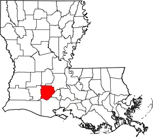 |
| Allen Parish | 003 | Oberlin | 1912 | from part of Calcasieu Parish. | Henry Watkins Allen, the Confederate governor of Louisiana | 25,627 | 766 sq mi (1,984 km2) | 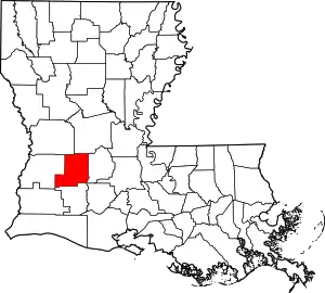 |
| Ascension Parish | 005 | Donaldsonville | 1807 | One of the original 19 parishes. | Named for the Ascension of Our Lord Catholic Church in Donaldsonville, Louisiana, which was named after the Ascension of Jesus into Heaven | 126,604 | 303 sq mi (785 km2) | 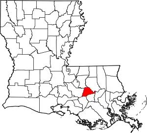 |
| Assumption Parish | 007 | Napoleonville | 1807 | One of the original 19 parishes. | Named for the Assumption Roman Catholic Church, the oldest in the state, which was named after the Assumption of the Virgin Mary | 21,891 | 364 sq mi (943 km2) | 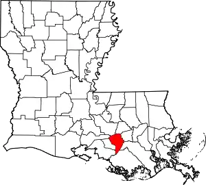 |
| Avoyelles Parish | 009 | Marksville | 1807 | One of the original 19 parishes. | The Avoyel Native American people | 40,144 | 866 sq mi (2,243 km2) | 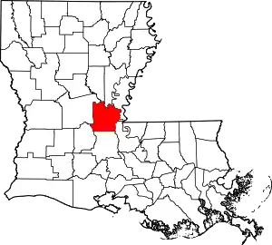 |
| Beauregard Parish | 011 | DeRidder | 1912 | from part of Calcasieu Parish. | Confederate general P. G. T. Beauregard | 37,497 | 1,166 sq mi (3,020 km2) | 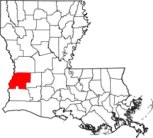 |
| Bienville Parish | 013 | Arcadia | 1848 | from part of Claiborne Parish. | Named after the founder of the city of New Orleans, Jean-Baptiste Le Moyne de Bienville | 13,241 | 822 sq mi (2,129 km2) | 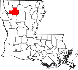 |
| Bossier Parish | 015 | Benton | 1843 | from part of Claiborne Parish. | U.S. Representative Pierre Bossier | 127,039 | 867 sq mi (2,246 km2) | 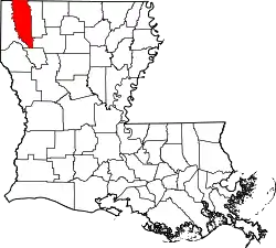 |
| Caddo Parish | 017 | Shreveport | 1838 | from part of Natchitoches Parish. | From Caddo. Named for the Caddo Native American people | 240,204 | 937 sq mi (2,427 km2) | 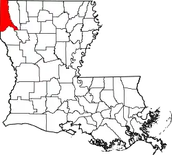 |
| Calcasieu Parish | 019 | Lake Charles | 1840 | from part of St. Landry Parish. | From Atakapa Calcasieu, meaning crying eagle, is said to be the name of an Atakapa Native American leader | 203,436 | 1,094 sq mi (2,833 km2) | 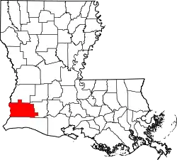 |
| Caldwell Parish | 021 | Columbia | 1838 | from part of Catahoula Parish and Ouachita Parish. | Named for the Caldwell family, which owned a large plantation and remains politically active in the state. | 9,918 | 541 sq mi (1,401 km2) | 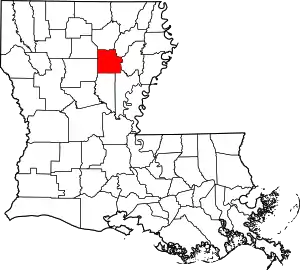 |
| Cameron Parish | 023 | Cameron | 1870 | from parts of Calcasieu Parish and Vermilion Parish. | U.S. Secretary of War Simon Cameron | 6,973 | 1,932 sq mi (5,004 km2) | 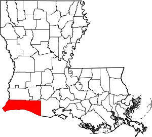 |
| Catahoula Parish | 025 | Harrisonburg | 1808 | from parts of Ouachita Parish and Rapides Parish. | Catahoula Lake, formerly within the parish's boundaries and named from a Taensa/Natchez word meaning big, clear lake | 9,494 | 739 sq mi (1,914 km2) | 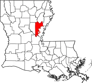 |
| Claiborne Parish | 027 | Homer | 1828 | from part of Natchitoches Parish. | Governor of Louisiana William C. C. Claiborne | 15,670 | 768 sq mi (1,989 km2) | 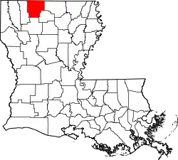 |
| Concordia Parish | 029 | Vidalia | 1807 | One of the original 19 parishes. | Name is of uncertain origin; may be from an early land grant called New Concordia, from the "concord" reached by local authorities over a mutual surrender of slaves or for a mansion called Concord which was owned by Spanish Governor Manuel Gayoso de Lemos | 19,259 | 749 sq mi (1,940 km2) | 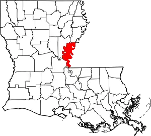 |
| DeSoto Parish | 031 | Mansfield | 1843 | from parts of Caddo Parish and Natchitoches Parish. | Spanish explorer Hernando de Soto | 27,463 | 895 sq mi (2,318 km2) | 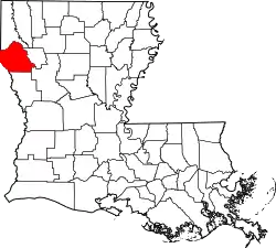 |
| East Baton Rouge Parish | 033 | Baton Rouge | 1810 | from West Florida territory. | French phrase bâton rouge meaning red stick. A red stick was used by local Native Americans to mark the boundaries between tribal territories | 440,059 | 471 sq mi (1,220 km2) | 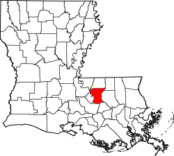 |
| East Carroll Parish | 035 | Lake Providence | 1877 | when Carroll Parish was divided. | Charles Carroll of Carrollton, the last surviving signer of the U.S. Declaration of Independence | 6,861 | 442 sq mi (1,145 km2) | 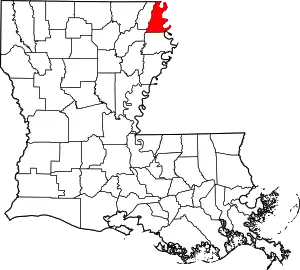 |
| East Feliciana Parish | 037 | Clinton | 1824 | when Feliciana Parish was divided. | Felicite de Gálvez, the wife of Bernardo de Gálvez, a Spanish governor of Louisiana (New Spain) | 19,135 | 456 sq mi (1,181 km2) | 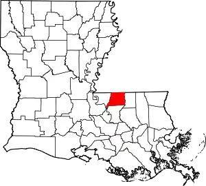 |
| Evangeline Parish | 039 | Ville Platte | 1910 | from part of St. Landry Parish. | Acadian heroine of the poem "Evangeline" by Henry Wadsworth Longfellow | 33,395 | 680 sq mi (1,761 km2) | 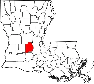 |
| Franklin Parish | 041 | Winnsboro | 1843 | from parts of Carroll Parish, Catahoula Parish, Madison Parish and Ouachita Parish | Founding Father Benjamin Franklin | 20,015 | 636 sq mi (1,647 km2) | 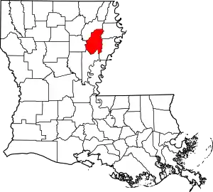 |
| Grant Parish | 043 | Colfax | 1869 | from parts of Rapides Parish and Winn Parish. | U.S. President Ulysses S. Grant | 22,389 | 664 sq mi (1,720 km2) | 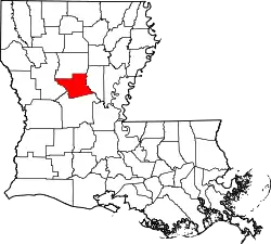 |
| Iberia Parish | 045 | New Iberia | 1868 | from parts of St. Martin Parish and St. Mary Parish. | Named by Spanish settlers in honor of the Iberian Peninsula | 69,830 | 1,031 sq mi (2,670 km2) | 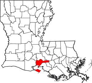 |
| Iberville Parish | 047 | Plaquemine | 1807 | One of the original 19 parishes. | Explorer Pierre Le Moyne d'Iberville, the brother of Jean-Baptiste Le Moyne de Bienville | 32,511 | 653 sq mi (1,691 km2) | 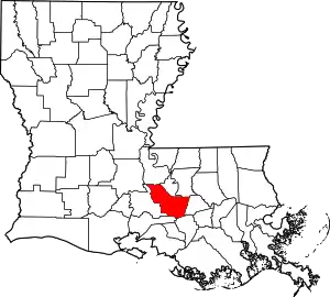 |
| Jackson Parish | 049 | Jonesboro | 1845 | from parts of Claiborne Parish, Ouachita Parish and Union Parish | U.S. President Andrew Jackson | 15,744 | 580 sq mi (1,502 km2) | 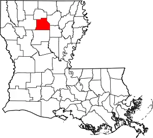 |
| Jefferson Parish | 051 | Gretna | 1825 | from part of Orleans Parish | Founding Father Thomas Jefferson | 432,493 | 642 sq mi (1,663 km2) | 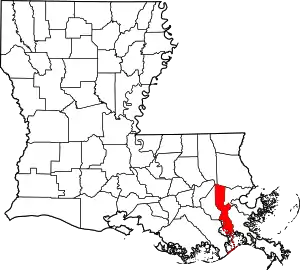 |
| Jefferson Davis Parish | 053 | Jennings | 1912 | from part of Calcasieu Parish. | Jefferson Davis, president of the Confederate States of America | 31,368 | 659 sq mi (1,707 km2) | 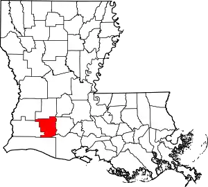 |
| Lafayette Parish | 055 | Lafayette | 1823 | from part of St. Martin Parish. | French-born American Revolutionary War hero, the Marquis de Lafayette | 244,390 | 270 sq mi (699 km2) | 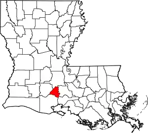 |
| Lafourche Parish | 057 | Thibodaux | 1807 | One of the original 19 parishes. Was named Interior Parish until 1812 and Lafourche Interior Parish until 1853. | French phrase la fourche or in English, the fork; Bayou Lafourche, or Fork Bayou, is a fork of the Mississippi River | 97,614 | 1,472 sq mi (3,812 km2) | 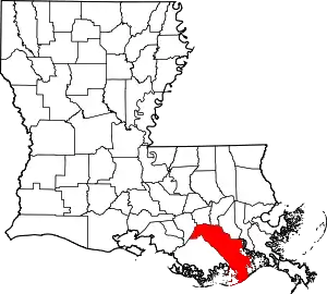 |
| LaSalle Parish | 059 | Jena | 1910 | from west half of Catahoula Parish. | Explorer René-Robert Cavelier, Sieur de La Salle | 14,892 | 663 sq mi (1,717 km2) | 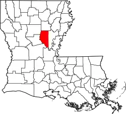 |
| Lincoln Parish | 061 | Ruston | 1873 | from parts of Bienville Parish, Claiborne Parish, Jackson Parish and Union Parish. | U.S. President Abraham Lincoln | 46,742 | 472 sq mi (1,222 km2) | 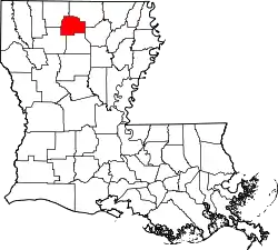 |
| Livingston Parish | 063 | Livingston | 1832 | from part of St. Helena Parish. | U.S. Secretary of State Edward Livingston, brother of Robert R. Livingston who negotiated the Louisiana Purchase | 140,789 | 703 sq mi (1,821 km2) | 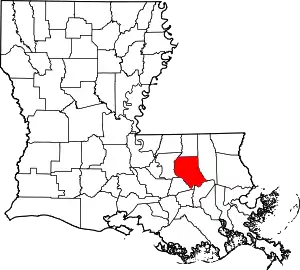 |
| Madison Parish | 065 | Tallulah | 1838 | from Concordia Parish. | U.S. President James Madison | 10,951 | 651 sq mi (1,686 km2) | 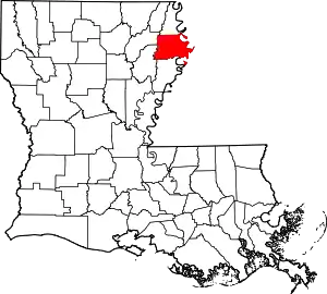 |
| Morehouse Parish | 067 | Bastrop | 1844 | from parts of Carroll Parish and Ouachita Parish. | Abraham Morehouse, who led the first settlers into the region | 24,874 | 805 sq mi (2,085 km2) | 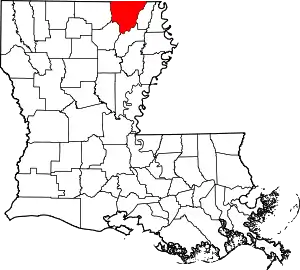 |
| Natchitoches Parish | 069 | Natchitoches | 1807 | One of the original 19 parishes. | The Natchitoches Native American people | 38,158 | 1,299 sq mi (3,364 km2) | 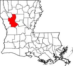 |
| Orleans Parish | 071 | New Orleans | 1807 | One of the original 19 parishes. Today coterminous with the City of New Orleans. | Named after Philippe, Duke of Orléans, the regent of France | 390,144 | 350 sq mi (906 km2) | 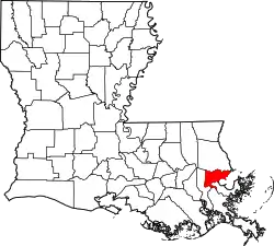 |
| Ouachita Parish | 073 | Monroe | 1807 | One of the original 19 parishes. | The Ouachita Native American people | 153,279 | 633 sq mi (1,639 km2) | 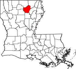 |
| Plaquemines Parish | 075 | Pointe à la Hache | 1807 | One of the original 19 parishes. | A word meaning persimmons created from the Louisiana Creole and the Atakapa language | 23,197 | 2,429 sq mi (6,291 km2) | 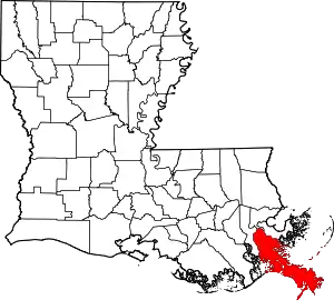 |
| Pointe Coupee Parish | 077 | New Roads | 1807 | One of the original 19 parishes. | French phrase la pointe coupée or in English, the cut-off point, which refers to a bend in the Mississippi River | 21,730 | 591 sq mi (1,531 km2) |  |
| Rapides Parish | 079 | Alexandria | 1807 | One of the original 19 parishes. | Named for local river rapids (French: rapides) | 129,648 | 1,362 sq mi (3,528 km2) | 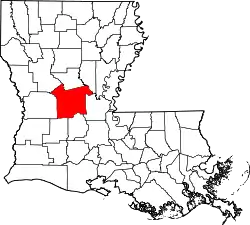 |
| Red River Parish | 081 | Coushatta | 1871 | from parts of Bienville Parish, Bossier Parish, Caddo Parish and Natchitoches Parish. | Named for the Red River, which is part of the Mississippi River watershed | 8,442 | 402 sq mi (1,041 km2) | 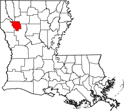 |
| Richland Parish | 083 | Rayville | 1868 | from parts of Carroll Parish, Franklin Parish, Morehouse Parish and Ouachita Parish. | Named for its rich land | 20,122 | 564 sq mi (1,461 km2) | 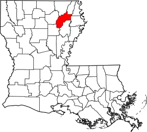 |
| Sabine Parish | 085 | Many | 1843 | from parts of Caddo Parish and Natchitoches Parish. | Named for the Sabine River and the so-called Sabine Free State | 23,884 | 1,012 sq mi (2,621 km2) | 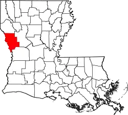 |
| St. Bernard Parish | 087 | Chalmette | 1807 | One of the original 19 parishes. | Saint Bernard, patron saint of Bernardo de Gálvez, the Spanish governor who granted land to the Canary Islanders settling the area in 1778 | 47,244 | 1,794 sq mi (4,646 km2) | 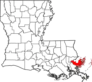 |
| St. Charles Parish | 089 | Hahnville | 1807 | One of the original 19 parishes. | Saint Charles | 53,100 | 410 sq mi (1,062 km2) | 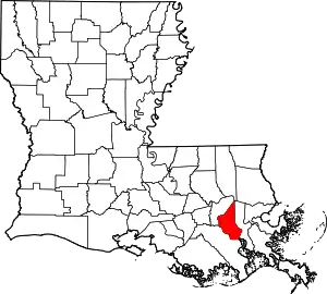 |
| St. Helena Parish | 091 | Greensburg | 1810 | from West Florida territory. | Saint Helena | 10,132 | 409 sq mi (1,059 km2) | 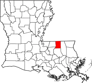 |
| St. James Parish | 093 | Convent | 1807 | One of the original 19 parishes. | Saint James the Great | 21,096 | 258 sq mi (668 km2) | 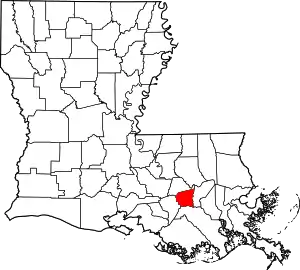 |
| St. John the Baptist Parish | 095 | Edgard | 1807 | One of the original 19 parishes. | Saint John the Baptist | 42,837 | 348 sq mi (901 km2) | 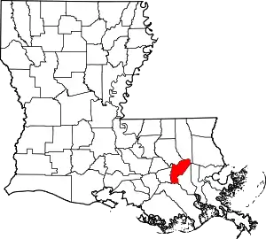 |
| St. Landry Parish | 097 | Opelousas | 1807 | One of the original 19 parishes. | Saint Landry of Paris | 82,124 | 939 sq mi (2,432 km2) | 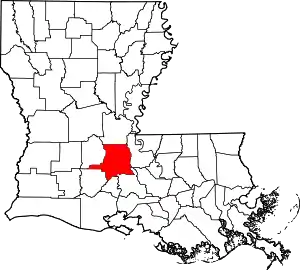 |
| St. Martin Parish | 099 | St. Martinville | 1807 | One of the original 19 parishes. | Saint Martin of Tours | 53,431 | 817 sq mi (2,116 km2) | 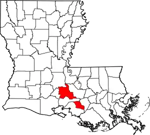 |
| St. Mary Parish | 101 | Franklin | 1811 | from part of St. Martin Parish. | Saint Mary | 49,348 | 612 sq mi (1,585 km2) | 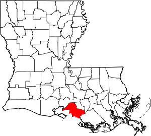 |
| St. Tammany Parish | 103 | Covington | 1810 | from West Florida territory. | Legendary Indian Chief Tamanend. | 260,419 | 1,124 sq mi (2,911 km2) | 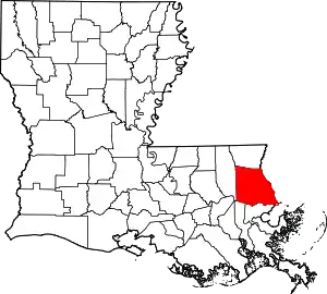 |
| Tangipahoa Parish | 105 | Amite City | 1869 | from parts of Livingston Parish, St. Helena Parish, St. Tammany Parish and Washington Parish. | Comes from an Acolapissa word meaning ear of corn or those who gather corn | 134,758 | 823 sq mi (2,132 km2) | 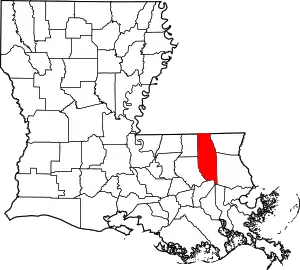 |
| Tensas Parish | 107 | St. Joseph | 1843 | from part of Concordia Parish. | The Taensa Native American people. | 4,334 | 641 sq mi (1,660 km2) | 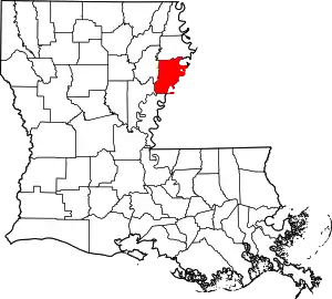 |
| Terrebonne Parish | 109 | Houma | 1822 | from part of Lafourche Interior Parish. | French phrase terre bonne or in English, good earth | 110,461 | 2,080 sq mi (5,387 km2) | 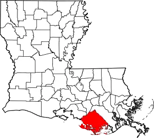 |
| Union Parish | 111 | Farmerville | 1839 | from part of Ouachita Parish. | Named for the union of states which make up the U.S. | 22,108 | 905 sq mi (2,344 km2) | 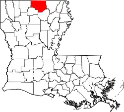 |
| Vermilion Parish | 113 | Abbeville | 1844 | from part of Lafayette Parish. | Both the Vermilion River and Vermilion Bay | 59,511 | 1,538 sq mi (3,983 km2) | 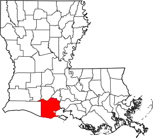 |
| Vernon Parish | 115 | Leesville | 1871 | from parts of Natchitoches Parish, Rapides Parish and Sabine Parish. | Mount Vernon, the home of George Washington, the first U.S. President | 47,429 | 1,341 sq mi (3,473 km2) | 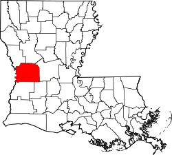 |
| Washington Parish | 117 | Franklinton | 1819 | from part of St. Tammany Parish. | U.S. President George Washington | 46,194 | 676 sq mi (1,751 km2) | 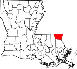 |
| Webster Parish | 119 | Minden | 1871 | from parts of Bienville Parish, Bossier Parish and Claiborne Parish. | U.S. Secretary of State Daniel Webster | 38,340 | 615 sq mi (1,593 km2) | 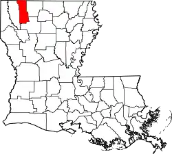 |
| West Baton Rouge Parish | 121 | Port Allen | 1807 | One of the original 19 parishes. Was named Baton Rouge Parish until 1812. | French phrase bâton rouge meaning red stick. A red stick was used by local Native Americans to mark the boundaries between tribal territories | 26,465 | 203 sq mi (526 km2) | 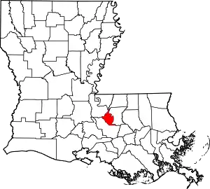 |
| West Carroll Parish | 123 | Oak Grove, West Carroll Parish | 1877 | when Carroll Parish was divided. | Charles Carroll of Carrollton, the last surviving signer of the U.S. Declaration of Independence | 10,830 | 360 sq mi (932 km2) | 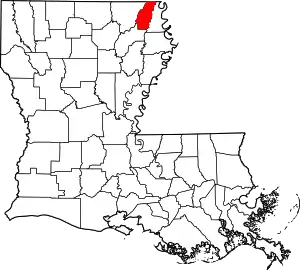 |
| West Feliciana Parish | 125 | St. Francisville | 1824 | when Feliciana Parish was divided. | Felicite de Gálvez, the wife of Bernardo de Gálvez, a Spanish governor of Louisiana (New Spain) | 15,568 | 426 sq mi (1,103 km2) | 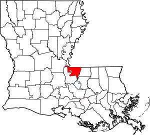 |
| Winn Parish | 127 | Winnfield | 1852 | from parts of Catahoula Parish, Natchitoches Parish and Rapides Parish. | Louisiana state legislator Walter Winn | 13,904 | 957 sq mi (2,479 km2) | 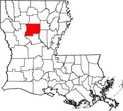 |
Former parishes
- Attakapas Parish existed from 1805 to 1811.
- Biloxi Parish formed in 1811 from West Florida territory. It was eliminated in 1812 when it was transferred to the Mississippi Territory.[2]
- Carroll Parish formed in 1838 from part of Ouachita Parish. In 1877, it was divided into East Carroll Parish and West Carroll Parish.[2]
- Feliciana Parish formed in 1810 from West Florida territory. In 1824, it was divided into East Feliciana Parish and West Feliciana Parish.[2]
- German Coast Parish existed from 1805 to 1807.
- Opelousas Parish
- Pascagoula Parish formed in 1811 from West Florida territory. It was eliminated in 1812 when it was transferred to the Mississippi Territory.[2]
- Warren Parish formed in 1811 from part of Concordia Parish, and merged into Concordia Parish and Ouachita Parish in 1814.[2]
Counties in 1803
The original twelve counties (later, parishes) defined by the Territorial Legislative Council in 1803 were:
- Acadia Parish
- Attakapas County
- Concordia Parish
- German Coast County
- Iberville Parish
- Lafourche Parish
- Natchitoches Parish
- Opelousas County
- Orleans County
- Ouachita Parish
- Pointe Coupee Parish
- Rapides Parish
In 1807, German Coast County was divided into several different parishes, when the Territorial Council revised the list from 12 to 19. Similarly, in 1811 Attakapas County was subdivided. The names German Coast and Attakapas were dropped when the counties were divided, merged or changed into parishes.
Fictional parishes
- In the novels Little Altars Everywhere, Divine Secrets of the Ya-Ya Sisterhood, and Ya-Yas in Bloom, author Rebecca Wells created the fictional "Garnet Parish".
- The movie Steel Magnolias was said to take place in the fictional "Chinquapin Parish", likely a suburban parish of Shreveport. However, the movie was shot in Natchitoches, and involved several elements of culture indicative of the town and parish of the same name. For example, the annual Christmas Festival of Lights in Natchitoches is shown, as are Cajun dance styles with a distinctive country-Cajun band. (Natchitoches is in the Crossroads region of Louisiana, where southern Louisiana's predominantly Catholic, Cajun culture meets the primarily Protestant, Anglo culture of northern Louisiana.)
- Part of Walter Jon Williams' novel The Rift is set in the fictional "Spottswood Parish".
- The Southern Vampire Mysteries series of novels written by Charlaine Harris and HBO's True Blood, which is based on the novels, take place in the fictional northwestern Louisiana "Renard Parish".
- In the movie In the Electric Mist, Deputy Jason J. Bayard was from the fictional "St. Clare Parish".
- In the DC Comics Universe, "Belle Reve Parish" is a parish in Louisiana that contains the Bell Reve Penitentiary.
- In the movie The Green Mile, a fictional parish named "Trapingus Parish" is featured in the movie. The film was actually shot in Tennessee.
- In the Cinemax TV series Banshee, Chayton Littlestone is seen fighting in a fictional parish named "Sang Tholis", which is said to be in New Orleans. "Sang" is the French word for "blood", but could also be a dialect for "sans", without. "Tholis" is not a French word.
- In the movie Doctor Detroit, protagonist Clifford Skridlow (played by Dan Aykroyd) appears in a Detroit court as a stereotypical (based on "Atticus Finch" in To Kill a Mockingbird) Southern attorney from "Bay Saint Louis Parish".
- In the 2017 video game Resident Evil 7: Biohazard, the vast majority of the game takes place in the fictional Dulvey Parish, somewhere on the coast.
- The "Faster, Baby!" DLC for Mafia III, also a 2017 video game, takes place in 'Sinclair Parish' just west of the fictional city of 'New Bordeaux', a fictional version of New Orleans set in 1968.
- Designated Survivor Season 2 features a flu outbreak that originates in South Carroll Parish.
References
- "Parish Government Structure - Police Jury Association of Louisiana". Police Jury Association of LA. Retrieved February 23, 2019.
- Tabor, B. "Bryansite - Louisiana parishes".
- The Admission of Louisiana into the Union
- "EPA County FIPS Code Listing". EPA.gov. Retrieved 2008-02-23.
- U.S. Census Bureau, Population Division. "Annual Estimates of the Resident Population for Counties in Louisiana: April 1, 2010 to July 1, 2019 (CO-EST2019-ANNRES-22)". Archived from the original on March 27, 2020. Retrieved 2020-05-12.
- Louisiana Dept. of Public Health Parish Profiles Archived 2005-11-17 at the Wayback Machine
|