Lafourche Parish, Louisiana
Lafourche Parish (French: Paroisse de la Fourche) is a parish located in the south of the U.S. state of Louisiana. As of the 2010 census, the population was 96,318.[1] The parish seat is Thibodaux.[2] The parish was formed in 1807.[3] It was originally the northern part of Lafourche Interior Parish, which consisted of the present parishes of Lafourche and Terrebonne. Lafourche Parish was named after the Bayou Lafourche.[4] The city buildings have also been featured in television and movies, such as in Fletch Lives, due to its architecture and rich history.
Lafourche Parish | |
|---|---|
Parish | |
| Parish of Lafourche | |
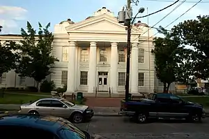 Lafourche Parish Courthouse | |
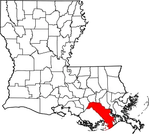 Location within the U.S. state of Louisiana | |
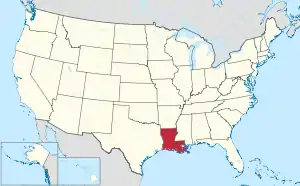 Louisiana's location within the U.S. | |
| Coordinates: 29°29′N 90°24′W | |
| Country | |
| State | |
| Founded | 1807 |
| Named for | la fourche, French for the fork |
| Seat | Thibodaux |
| Largest city | Thibodaux |
| Area | |
| • Total | 1,474 sq mi (3,820 km2) |
| • Land | 1,068 sq mi (2,770 km2) |
| • Water | 406 sq mi (1,050 km2) 28% |
| Population (2010) | |
| • Total | 96,318 |
| • Estimate (2018) | 98,115 |
| • Density | 65/sq mi (25/km2) |
| Time zone | UTC−6 (Central) |
| • Summer (DST) | UTC−5 (CDT) |
| Congressional districts | 1st, 6th |
| Website | www |
Long a center of sugar cane plantations and sugar production, in November 1887 the parish was the site of the Thibodaux Massacre. After state militia were used to suppress a massive Knights of Labor strike involving 10,000 workers in four parishes, many African Americans retreated to Thibodaux. Local paramilitary forces attacked the men and their families, killing an estimated 50 persons, and hundreds more were missing, wounded, and presumed dead in one of the deadliest incidents of labor suppression and racial terrorism.
Lafourche Parish is part of the Houma-Thibodaux, LA Metropolitan Statistical Area. People of the state-recognized Native American Houma Tribe live in both Lafourche and Terrebonne parishes.
History
South Louisiana became known as Sugarland, and Lafourche one of the sugar parishes, where sugar cane plantations were established before and after the Civil War. They required the labor of large numbers of enslaved African Americans. In the postbellum era, they comprised from 50 to 80 percent of the population in most of the sugar parishes.[5]
Particularly after Reconstruction, whites in the parish used violence and intimidation against the large population of freedmen to suppress Republican voting and re-establish white supremacy, but were less successful than in North Louisiana until after disenfranchisement of blacks at the turn of the century.[5] From 1877 through the early 20th century, there were 52 lynchings of African Americans in Lafourche Parish. Most of the deaths were due to white suppression of labor unrest in 1887; blacks were skilled sugar workers and had begun to organize for better wages and conditions.[5] Some 10,000 workers had struck in Lafourche and three other parishes during the critical harvest period. At the request of the planters, the state sent in militia against the workers to break the strike.
In what was called the Thibodaux Massacre of November 22, 1887, local whites organized by leaders of the town killed up to 50 blacks who had taken refuge in the African-American quarters after a major Knights of Labor strike was called on sugar plantations. Hundreds more were wounded or missing.[6]
The total deaths in this parish due to this racial terrorism were the highest of any parish in the state and nearly twice as high as some others among the six parishes with the highest totals.[7] In general, most of the lynching and racial terrorism took place in the late 19th and early 20th centuries.
Geography
According to the U.S. Census Bureau, the parish has a total area of 1,474 square miles (3,820 km2), of which 1,068 square miles (2,770 km2) is land and 406 square miles (1,050 km2) (28%) is water.[8] To the south of the parish is the Gulf of Mexico.
Major highways
Adjacent parishes
- St. James Parish (north)
- St. John the Baptist Parish (north)
- St. Charles Parish (northeast)
- Jefferson Parish (east)
- Terrebonne Parish (west)
- Assumption Parish (northwest)
National protected area
Demographics
| Historical population | |||
|---|---|---|---|
| Census | Pop. | %± | |
| 1810 | 1,995 | — | |
| 1820 | 3,755 | 88.2% | |
| 1830 | 5,503 | 46.6% | |
| 1840 | 7,303 | 32.7% | |
| 1850 | 9,532 | 30.5% | |
| 1860 | 14,044 | 47.3% | |
| 1870 | 14,719 | 4.8% | |
| 1880 | 19,113 | 29.9% | |
| 1890 | 22,095 | 15.6% | |
| 1900 | 28,882 | 30.7% | |
| 1910 | 33,111 | 14.6% | |
| 1920 | 30,344 | −8.4% | |
| 1930 | 32,419 | 6.8% | |
| 1940 | 38,615 | 19.1% | |
| 1950 | 42,209 | 9.3% | |
| 1960 | 55,381 | 31.2% | |
| 1970 | 68,941 | 24.5% | |
| 1980 | 82,483 | 19.6% | |
| 1990 | 85,860 | 4.1% | |
| 2000 | 89,974 | 4.8% | |
| 2010 | 96,318 | 7.1% | |
| 2018 (est.) | 98,115 | [9] | 1.9% |
| U.S. Decennial Census[10] 1790-1960[11] 1900-1990[12] 1990-2000[13] 2010-2013[1] | |||
As of the census of 2000, there were 89,974 people, 32,057 households, and 24,299 families residing in the parish. The latest estimates are at 90,255. The population density was 83 people per square mile (32/km2). There were 35,045 housing units at an average density of 32 per square mile (12/km2). The racial makeup of the parish was 82.85% White, 12.61% Black or African American, 2.30% Native American, 0.67% Asian, 0.02% Pacific Islander, 0.58% from other races, and 0.97% from two or more races. 1.43% of the population were Hispanic or Latino of any race. 19.12% reported speaking French or Cajun French at home, while 1.51% speak Spanish.[14]
There were 32,057 households, out of which 37.80% had children under the age of 18 living with them, 59.10% were married couples living together, 12.40% had a female householder with no husband present, and 24.20% were non-families. 19.60% of all households were made up of individuals, and 7.80% had someone living alone who was 65 years of age or older. The average household size was 2.75 and the average family size was 3.17.
In the parish the population was spread out, with 27.30% under the age of 18, 10.50% from 18 to 24, 29.70% from 25 to 44, 21.30% from 45 to 64, and 11.30% who were 65 years of age or older. The median age was 34 years. For every 100 females, there were 95.20 males. For every 100 females age 18 and over, there were 91.30 males.
The median income for a household in the parish was $34,910, and the median income for a family was $40,504. Males had a median income of $34,600 versus $19,484 for females. The per capita income for the parish was $15,809. About 13.20% of families and 16.50% of the population were below the poverty line, including 21.90% of those under age 18 and 18.30% of those age 65 or over.
Education
The parish is zoned to Lafourche Parish Public Schools.[15]
Residents of select portions of Lafourche Parish (particularly in parts of Grand Bois and Bourg) may attend schools in the Terrebonne Parish School District.[16]
High schools
- Central Lafourche in Mathews
- South Lafourche in Galliano
- Thibodaux High in Thibodaux
- Edward Douglas White Catholic High School in Thibodaux
University
- Nicholls State University in Thibodaux
National Guard
D Company 2-156 Infantry Battalion of the 256TH Infantry Brigade Combat Team resides in Thibodaux, Louisiana
Communities
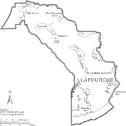
City
- Thibodaux (parish seat)
Towns
Census-designated places
Other areas
- Gheens
- Leeville
Notable people
- Donald G. Bollinger
- Thomas G. Clausen
- Francis Dugas
- Dick Guidry
- Bobby Hebert, former NFL quarterback
- Harvey Peltier, Jr.
- Harvey Peltier, Sr.
- Glen Pitre
- Loulan Pitre, Jr.
- Ed Orgeron
- Mattie Breaux, cast member of Party Down South
Politics
| Year | Republican | Democratic | Third parties |
|---|---|---|---|
| 2020 | 79.4% 36,024 | 19.1% 8,672 | 1.5% 692 |
| 2016 | 76.7% 31,959 | 20.2% 8,423 | 3.0% 1,263 |
| 2012 | 73.2% 28,592 | 24.6% 9,623 | 2.2% 860 |
| 2008 | 71.5% 27,089 | 25.5% 9,662 | 3.0% 1,142 |
| 2004 | 60.0% 22,734 | 38.1% 14,417 | 1.9% 713 |
| 2000 | 53.9% 18,575 | 42.5% 14,627 | 3.6% 1,247 |
| 1996 | 35.0% 12,105 | 54.4% 18,810 | 10.6% 3,681 |
| 1992 | 35.8% 12,744 | 45.4% 16,182 | 18.9% 6,719 |
| 1988 | 50.2% 16,152 | 46.7% 15,013 | 3.2% 1,014 |
| 1984 | 65.4% 20,930 | 31.8% 10,186 | 2.8% 889 |
| 1980 | 48.5% 14,951 | 46.2% 14,222 | 5.3% 1,645 |
| 1976 | 43.5% 11,434 | 53.8% 14,131 | 2.7% 701 |
| 1972 | 67.2% 13,936 | 27.6% 5,713 | 5.3% 1,088 |
| 1968 | 22.6% 4,797 | 26.0% 5,516 | 51.4% 10,910 |
| 1964 | 33.9% 6,164 | 66.2% 12,045 | |
| 1960 | 18.3% 2,930 | 76.3% 12,244 | 5.5% 881 |
| 1956 | 60.3% 5,741 | 36.4% 3,466 | 3.4% 321 |
| 1952 | 40.9% 3,739 | 59.1% 5,396 | |
| 1948 | 21.1% 1,247 | 26.8% 1,586 | 52.1% 3,080 |
| 1944 | 14.9% 875 | 85.1% 4,980 | |
| 1940 | 23.2% 1,065 | 76.8% 3,531 | |
| 1936 | 42.6% 1,630 | 57.4% 2,195 | 0.1% 2 |
| 1932 | 12.2% 364 | 87.8% 2,623 | 0.0% 1 |
| 1928 | 10.9% 243 | 89.1% 1,994 | |
| 1924 | 47.4% 611 | 52.6% 678 | |
| 1920 | 75.6% 1,044 | 24.4% 337 | |
| 1916 | 8.1% 157 | 32.5% 629 | 59.4% 1,149 |
| 1912 | 26.9% 315 | 57.0% 667 | 16.1% 189 |
See also
References
- "State & County QuickFacts". United States Census Bureau. Archived from the original on June 6, 2011. Retrieved August 10, 2013.
- "Find a County". National Association of Counties. Retrieved 2011-06-07.
- "Lafourche Parish". Center for Cultural and Eco-Tourism. Retrieved September 6, 2014.
- Gannett, Henry (1905). The Origin of Certain Place Names in the United States. Government Printing Office. p. 179.
- [ Michael James Pfeifer, Rough Justice: Lynching and American Society, 1874-1947], University of Illinois Press, 2004, pp. 75-77
- Bell, Ellen Baker, "Thibodaux Massacre (1887)", KnowLA Encyclopedia of Louisiana, 15 September 2011, accessdate 23 April 2017
- Lynching in America, Third Edition: Supplement by County Archived 2017-10-23 at the Wayback Machine, p. 6, Equal Justice Initiative, Mobile, AL, 2017
- "2010 Census Gazetteer Files". United States Census Bureau. August 22, 2012. Archived from the original on September 28, 2013. Retrieved September 1, 2014.
- "Population and Housing Unit Estimates". Retrieved October 29, 2019.
- "U.S. Decennial Census". United States Census Bureau. Archived from the original on May 12, 2015. Retrieved September 1, 2014.
- "Historical Census Browser". University of Virginia Library. Retrieved September 1, 2014.
- "Population of Counties by Decennial Census: 1900 to 1990". United States Census Bureau. Retrieved September 1, 2014.
- "Census 2000 PHC-T-4. Ranking Tables for Counties: 1990 and 2000" (PDF). United States Census Bureau. Retrieved September 1, 2014.
- Language Map Data Center
- "Home Page - Lafourche Parish School District". lafourche.k12.la.us. Retrieved 2018-03-06.
- "SCHOOL ATTENDANCE BOUNDARIES Archived 2016-12-02 at the Wayback Machine." Lafourche Parish Public Schools. Retrieved on December 2, 2016.
- Leip, David. "Dave Leip's Atlas of U.S. Presidential Elections". uselectionatlas.org. Retrieved 2018-03-06.
External links
- Lafourche Parish
- Lafourche Parish Public Library
- VisitLafourche.com - Tourist commission site
- DigInLafourche.com - Events and Attractions
Places adjacent to Lafourche Parish, Louisiana | ||||||||||
|---|---|---|---|---|---|---|---|---|---|---|
| ||||||||||
Municipalities and communities of Lafourche Parish, Louisiana, United States | ||
|---|---|---|
| City | | |
| Towns | ||
| CDPs | ||
| Other Unincorporated communities | ||
| Footnotes | ‡This populated place also has portions in an adjacent parish or parishes | |
| ||
| Authority control |
|---|