Loess Plateau
The Loess Plateau, (Chinese: 黃土高原; pinyin: Huángtǔ Gāoyuán; lit. 'Yellow Earth Plateau'), is a 640,000 km2 (250,000 sq mi) plateau in north/northwest China with an elevation of 1,250–2,000 m (4,100–6,560 ft), located around the southern half of the Yellow River's Ordos Loop and the valleys of its two largest tributaries, the Wei and Fen Rivers. The Loess Plateau covers almost all of the provinces of Shaanxi and Shanxi and extends into parts of Henan, Gansu, Ningxia and Inner Mongolia. It was enormously important to Chinese history, as it formed one of the early cradles of Chinese civilization and its eroded silt is responsible for the great fertility of the North China Plain, along with the repeated and massively destructive floods of the Yellow River. Its soil has been called the "most highly erodible... on earth"[1] and conservation efforts and land management are a major focus of modern Chinese agriculture.
| Loess Plateau | |||||||
|---|---|---|---|---|---|---|---|
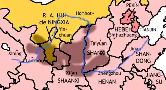 The Loess Plateau (shaded) | |||||||
| Traditional Chinese | 黃土高原 | ||||||
| Simplified Chinese | 黄土高原 | ||||||
| Literal meaning | The Yellow Earth Plateau | ||||||
| |||||||
Name
The area is named for its most distinctive feature, the highly friable "loess" (German for "loose"; Chinese: 黃土, huángtǔ, "yellow earth") soil that has been deposited by wind storms over the ages.[2]
History
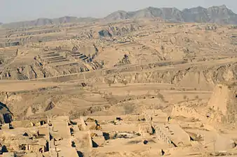
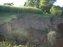
Historically the Loess Plateau has provided simple, insulated shelter from the cold winter and hot summer in the region, as homes called yaodong (窰洞) were often carved into the loess soil.[2] In medieval times people stayed here to grow rice; some families still live in this kind of shelter in modern times.
In ancient times, this region was an important center of the Silk Road.[3] Goods moving by caravan to the west included gold, rubies, jade, textiles, coral, ivory, and art works. In the opposite direction moved bronze weapons, furs, ceramics, and cinnamon bark.[4]
During the 1556 Shaanxi earthquake, 830,000 people were killed as a result of collapsing loess caves.
The yaodongs that are best known to the world are perhaps those in Yan'an where the Communist Party led by Mao Zedong headquartered in 1930s. When Edgar Snow, the author of Red Star Over China, visited Mao and his party, he lived in a yaodong.
Climate
The plateau generally has a semi-arid climate (Köppen BS), with extensive monsoonal influence. Winters are cold and dry, while summers are very warm and in many places hot. Rainfall tends to be heavily concentrated in summer, and the area receives extensive amounts of sunshine.
Agriculture and environment
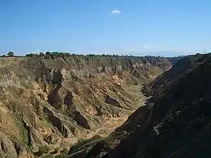
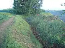
The Loess Plateau was formed over long geologic times, and scientists have derived valuable information about global climate change from samples taken from the deep layer of its silty soil.
The plateau was highly fertile and easy to farm in ancient times, which contributed to the development of early Chinese civilization around the Loess Plateau,[5] but centuries of overgrazing, subsistence farming, deforestation for fuel wood gathering and cultivation of crops on slopes, exacerbated by China's population increase, have resulted in degenerated ecosystems, desertification, and poor local economies.[6]
To reverse this trend, the Loess Plateau Watershed Rehabilitation Project was launched in 1994[7] to rehabilitate the land and improve the people's livelihoods. The project guided the people living on the plateau to change animal husbandry practices; encouraged natural regeneration of grasslands, tree and shrub cover on slope-lands previously used for farming; and land restoration through terracing and replanting. These efforts allowed the perennial vegetation cover to increase from 17 to 34 percent, and "[e]ven in the lifetime of the project, the ecological balance was restored in a vast area considered by many to be beyond help"; in addition, more than 2.5 million people were lifted out of poverty by doubled incomes.[6]
Restoration has occurred over an area of about 35,000 square kilometers (about 5% of the plateau's total area).[8] Results have reduced the massive silt loads to the Yellow River by about one percent.[9]
See also
- Yunnan–Guizhou Plateau
- Loess Hills of Western Iowa
- Palouse loess of Eastern Washington
References
- John M. Laflen, Soil Erosion and Dryland Farming, 2000, CRC Press, 736 pages ISBN 0-8493-2349-5
- Scheffel, Richard L.; Wernet, Susan J., eds. (1980). Natural Wonders of the World. United States of America: Reader's Digest Association, Inc. p. 341. ISBN 0-89577-087-3.
- Susan Whitfield, Life Along the Silk Road, 2001, University of California Press, 253 pages ISBN 0-520-23214-3
- C. Michael Hogan, Silk Road, North China, The Megalithic Portal, ed. A. Burnham
- Ho, P. (1998). "In Defense of Sinicization: A Rebuttal of Evelyn Rawski's 'Reenvisioning the Qing'". Journal of Asian Studies. 57 (1): 123–155 [p. 128]. doi:10.1017/S0021911800022713.
- "Restoring China's Loess Plateau". World Bank. 2007-03-15. Retrieved 2019-07-25.
- "Loess Plateau Watershed Rehabilitation Project". World Bank. Retrieved 2019-07-25.
- Hope in a Changing Climate, documentary film by John D. Liu, (9:39)
- World Bank, Reengaging in Agricultural Water Management: Challenges and Options, 2006, 218 pages ISBN 0-8213-6498-7