Logansville, Ohio
Logansville (also Loganville)[1] is an unincorporated community in central Pleasant Township, Logan County, Ohio, United States. It lies along State Route 47 at its intersection with County Road 24. The Great Miami River flows southward along the western edge of Logansville. The community lies 2½ miles (4 km) north of the village of De Graff and 9 miles (14½ km) west of the city of Bellefontaine, the county seat of Logan County.[2] It is located at 40°20′44″N 83°55′50″W (40.3456070, -83.9304936), and its altitude is 1,010 feet (308 m).[1]
Logansville, Ohio | |
|---|---|
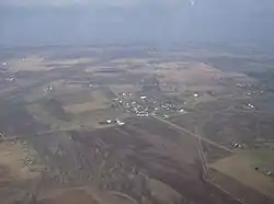 Aerial view of Logansville from the south | |
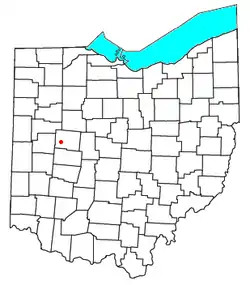 Location of Logansville, Ohio | |
| Coordinates: 40°20′44″N 83°55′50″W | |
| Country | United States |
| State | Ohio |
| County | Logan |
| Township | Pleasant |
| Time zone | UTC-5 (Eastern (EST)) |
| • Summer (DST) | UTC-4 (EDT) |
Logansville was platted in 1827, and named after Logan, an Indian tribal leader.[3] A post office called Logansville was established in 1835, and remained in operation until 1905.[4]
Logansville is served by the Logansville Community Church.[5]
References
- U.S. Geological Survey Geographic Names Information System: Logansville, Ohio
- DeLorme. Ohio Atlas & Gazetteer. 7th ed. Yarmouth: DeLorme, 2004, p. 56. ISBN 0-89933-281-1.
- Overman, William Daniel (1958). Ohio Town Names. Akron, OH: Atlantic Press. p. 77.
- "Logan County". Jim Forte Postal History. Retrieved 22 December 2015.
- "Logansville Community Church". Retrieved 21 August 2016.
External links
Municipalities and communities of Logan County, Ohio, United States | ||
|---|---|---|
| City |  Map of Ohio highlighting Logan County | |
| Villages | ||
| Townships | ||
| CDPs | ||
| Unincorporated communities | ||
| Ghost towns | ||
| Footnotes | ‡This populated place also has portions in an adjacent county or counties | |
| ||