Pickrelltown, Ohio
Pickrelltown is an unincorporated community in Logan County, Ohio.[1]
Pickrelltown, Ohio | |
|---|---|
 Aerial view of Pickrelltown from the east | |
 Location of Pickrelltown, Ohio | |
| Coordinates: 40°17′59″N 83°39′37″W | |
| Country | United States |
| State | Ohio |
| County | Logan |
| Township | Monroe |
| Time zone | UTC-5 (Eastern (EST)) |
| • Summer (DST) | UTC-4 (EDT) |
| GNIS feature ID | 1061538[1] |
The settlement is located at the intersection of County Roads 28 and 29 in northern Monroe Township. It is known for its unique round-a-bout in the middle of the intersection of the town.
Variant names of Pickrelltown include "Frogtown", "Pickereltown", "Pickeretown", and "Pickreltown".[1]
History
A post office was established at Pickrelltown in 1851, and remained in operation until 1903.[2] The community was named for Henry Pickerel, the proprietor of a local tanyard.[3]
Geography
Pickrelltown is a short distance south of Mad River Mountain Ski Resort and southeast of Bellefontaine. The headwaters of the Macochee Creek, a small stream that meets the Mad River at West Liberty, are located around Pickrelltown.[4]
Pigeon Town, a town of the Shawnee Mekoche division, was located on Mad River, 3 miles northwest of West Liberty, Logan County, Ohio.[5]
Notable people
- Solomon L. Hoge — South Carolina Supreme Court justice and U.S. representative from South Carolina
Gallery

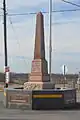 Rebuilt veterans memorial following its destruction in 2014.[6]
 Monroe Township hall at Pickrelltown.
 Monroe Community Church at Pickrelltown.
References
- U.S. Geological Survey Geographic Names Information System: Pickrelltown
- "Logan County". Jim Forte Postal History. Retrieved 22 December 2015.
- Overman, William Daniel (1958). Ohio Town Names. Akron, OH: Atlantic Press. p. 110.
- DeLorme. Ohio Atlas & Gazetteer. 7th ed. Yarmouth: DeLorme, 2004, p. 56. ISBN 0-89933-281-1.
- "Shawnee Indian Tribe History". Access Genealogy. Retrieved 2013-02-18.
- Tipple, Bill (April 28, 2014). "Serious Injury Crash in Pickrelltown, Monument Destroyed". PeakOfOhio.com.
- "Monument Destroyed". Bellefontaine Examiner. April 20, 2000.
External links
Municipalities and communities of Logan County, Ohio, United States | ||
|---|---|---|
| City | 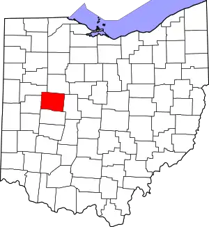 Map of Ohio highlighting Logan County | |
| Villages | ||
| Townships | ||
| CDPs | ||
| Unincorporated communities | ||
| Ghost towns | ||
| Footnotes | ‡This populated place also has portions in an adjacent county or counties | |
| ||
