Loganton, Pennsylvania
Loganton is a borough in Clinton County, Pennsylvania, United States. The population was 468 at the 2010 census.[3]
Loganton, Pennsylvania | |
|---|---|
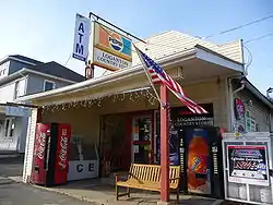 Loganton Country Store | |
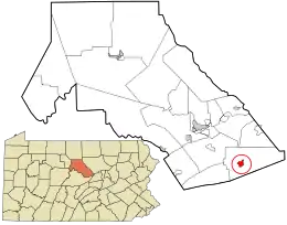 Location in Clinton County and the U.S. state of Pennsylvania. | |
| Coordinates: 41°02′03″N 77°18′23″W | |
| Country | United States |
| State | Pennsylvania |
| County | Clinton |
| Settled | 1840 |
| Incorporated (borough) | 1864 |
| Government | |
| • Type | Borough Council |
| Area | |
| • Total | 1.06 sq mi (2.73 km2) |
| • Land | 1.05 sq mi (2.73 km2) |
| • Water | 0.00 sq mi (0.01 km2) |
| Elevation | 1,297 ft (395 m) |
| Population (2010) | |
| • Total | 468 |
| • Estimate (2019)[2] | 478 |
| • Density | 453.94/sq mi (175.33/km2) |
| Time zone | Eastern (EST) |
| • Summer (DST) | EDT |
| ZIP code | 17747 |
| Area code(s) | 570 Exchange: 725 |
| FIPS code | 42-44400 |
Geography
Loganton is located in southern Clinton County at 41°02′15″N 77°18′30″W (41.034559, -77.305475).[4] It is in the Sugar Valley, part of the Ridge-and-Valley Appalachians, and is situated at the southern base of Sugar Valley Mountain. Pennsylvania Route 477 passes through the center of Loganton and leads north through a water gap in Sugar Valley Mountain 1.0 mile (1.6 km) to Exit 185 on Interstate 80. PA 477 leads south 6 miles (10 km) across Nittany Mountain to Livonia in the Brush Valley. Pennsylvania Route 880 crosses PA 477 in the center of Loganton and runs the length of Sugar Valley, leading east 6 miles (10 km) to Exit 192 on Interstate 80 and southwest 7 miles (11 km) to Tylersville.
According to the United States Census Bureau, Loganton has a total area of 1.0 square mile (2.7 km2), all of it land.[3]
Demographics
| Historical population | |||
|---|---|---|---|
| Census | Pop. | %± | |
| 1850 | 243 | — | |
| 1870 | 414 | — | |
| 1880 | 423 | 2.2% | |
| 1890 | 385 | −9.0% | |
| 1900 | 432 | 12.2% | |
| 1910 | 375 | −13.2% | |
| 1920 | 254 | −32.3% | |
| 1930 | 264 | 3.9% | |
| 1940 | 297 | 12.5% | |
| 1950 | 346 | 16.5% | |
| 1960 | 385 | 11.3% | |
| 1970 | 436 | 13.2% | |
| 1980 | 474 | 8.7% | |
| 1990 | 443 | −6.5% | |
| 2000 | 435 | −1.8% | |
| 2010 | 468 | 7.6% | |
| 2019 (est.) | 478 | [2] | 2.1% |
| Sources:[5][6][7] | |||
As of the census[6] of 2000, there were 435 people, 170 households, and 123 families residing in the borough. The population density was 411.7 people per square mile (158.4/km²). There were 176 housing units at an average density of 166.6 per square mile (64.1/km²). The racial makeup of the borough was 98.85% White, 0.23% African American, 0.69% Asian, and 0.23% from two or more races.
There were 170 households, out of which 29.4% had children under the age of 18 living with them, 62.4% were married couples living together, 7.6% had a female householder with no husband present, and 27.6% were non-families. 23.5% of all households were made up of individuals, and 14.1% had someone living alone who was 65 years of age or older. The average household size was 2.56 and the average family size was 2.98.
In the borough the population was spread out, with 23.0% under the age of 18, 6.4% from 18 to 24, 28.7% from 25 to 44, 24.8% from 45 to 64, and 17.0% who were 65 years of age or older. The median age was 40 years. For every 100 females there were 104.2 males. For every 100 females age 18 and over, there were 98.2 males.
The median income for a household in the borough was $38,250, and the median income for a family was $43,750. Males had a median income of $28,295 versus $19,688 for females. The per capita income for the borough was $16,773. About 3.6% of families and 4.4% of the population were below the poverty line, including 12.1% of those under age 18 and none of those age 65 or over.
Local Business
| Historical population | |||
|---|---|---|---|
| Census | Pop. | %± | |
| 1980 | 474 | — | |
| 1990 | 443 | −6.5% | |
| 2000 | 435 | −1.8% | |
| source:[8][9] | |||
Nicholas Meat Packing Co has a meat product manufacturing plant.
Kavkaz Restaurant serves Russian, Middle Eastern, Eastern European food.
External links
References
- "2019 U.S. Gazetteer Files". United States Census Bureau. Retrieved July 28, 2020.
- "Population and Housing Unit Estimates". United States Census Bureau. May 24, 2020. Retrieved May 27, 2020.
- "Geographic Identifiers: 2010 Census Summary File 1 (G001): Loganton borough, Pennsylvania". U.S. Census Bureau, American Factfinder. Archived from the original on February 13, 2020. Retrieved May 11, 2015.
- "US Gazetteer files: 2010, 2000, and 1990". United States Census Bureau. 2011-02-12. Retrieved 2011-04-23.
- "Census of Population and Housing". U.S. Census Bureau. Retrieved 11 December 2013.
- "U.S. Census website". United States Census Bureau. Retrieved 2008-01-31.
- "Incorporated Places and Minor Civil Divisions Datasets: Subcounty Resident Population Estimates: April 1, 2010 to July 1, 2012". Population Estimates. U.S. Census Bureau. Archived from the original on 17 June 2013. Retrieved 11 December 2013.
- "Clinton County Comprehensive Plan" (PDF). Clinton County, Pennsylvania. Archived from the original (PDF) on 2007-11-29. Retrieved 2007-09-19.
- "Population Change 1990–2000: Pennsylvania". Pennsylvania State Data Center. Archived from the original on 2007-11-17. Retrieved 2007-09-19.
Municipalities and communities of Clinton County, Pennsylvania, United States | ||
|---|---|---|
| City |  | |
| Boroughs | ||
| Townships | ||
| CDPs | ||
| Unincorporated communities | ||
| Footnotes | ‡This populated place also has portions in an adjacent county | |
| ||
| Authority control |
|---|