McElhattan, Pennsylvania
McElhattan is a census-designated place (CDP) in Wayne Township in southern Clinton County, Pennsylvania, United States. As of the 2010 census the population was 598.[2]
McElhattan, Pennsylvania | |
|---|---|
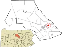 Location in Clinton County and the state of Pennsylvania. | |
| Coordinates: 41°09′35″N 77°21′41″W | |
| Country | United States |
| State | Pennsylvania |
| County | Clinton |
| Township | Wayne |
| Area | |
| • Total | 1.43 sq mi (3.71 km2) |
| • Land | 1.34 sq mi (3.48 km2) |
| • Water | 0.09 sq mi (0.23 km2) |
| Elevation | 577 ft (176 m) |
| Population (2010) | |
| • Total | 598 |
| • Density | 445/sq mi (171.8/km2) |
| Time zone | UTC-5 (Eastern (EST)) |
| • Summer (DST) | UTC-4 (EDT) |
| ZIP code | 17748 |
| FIPS code | 42-46112 |
| GNIS feature ID | 1180705[1] |
The community is located in eastern Clinton County and is bordered to the northwest by the West Branch of the Susquehanna River and to the southeast by U.S. Route 220, a four-lane freeway. The southwestern part of the CDP includes the area known as Youngdale. US 220 leads west 6 miles (10 km) to the city of Lock Haven, the Clinton County seat, and northeast 7 miles (11 km) to the borough of Jersey Shore. Bridge Road crosses the West Branch, connecting McElhattan with Dunnstable Township to the northwest.
References
- "McElhattan". Geographic Names Information System. United States Geological Survey.
- "Geographic Identifiers: 2010 Census Summary File 1 (G001): McElhattan CDP, Pennsylvania". U.S. Census Bureau, American Factfinder. Archived from the original on February 13, 2020. Retrieved May 19, 2015.
Municipalities and communities of Clinton County, Pennsylvania, United States | ||
|---|---|---|
| City | 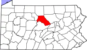 | |
| Boroughs | ||
| Townships | ||
| CDPs | ||
| Unincorporated communities | ||
| Footnotes | ‡This populated place also has portions in an adjacent county | |
| ||
This article is issued from Wikipedia. The text is licensed under Creative Commons - Attribution - Sharealike. Additional terms may apply for the media files.