Clinton County, Pennsylvania
Clinton County is a county located in the U.S. state of Pennsylvania. As of the 2010 census, the population was 39,238.[2] Its county seat is Lock Haven.[3] The county was created on June 21, 1839, from parts of Centre and Lycoming Counties. Its name is in honor of the seventh Governor of New York State, DeWitt Clinton, however some sources suggest the namesake is Henry Clinton.[4]
Clinton County | |
|---|---|
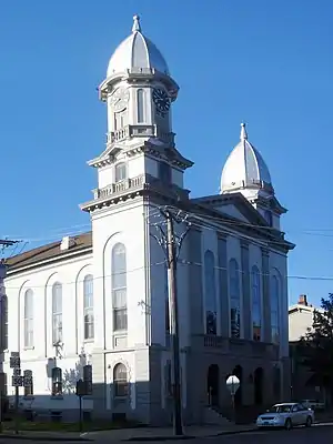 Clinton County Courthouse | |
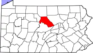 Location within the U.S. state of Pennsylvania | |
 Pennsylvania's location within the U.S. | |
| Coordinates: 41°14′N 77°38′W | |
| Country | |
| State | |
| Founded | June 21, 1839 |
| Named for | DeWitt Clinton |
| Seat | Lock Haven |
| Largest city | Lock Haven |
| Area | |
| • Total | 897 sq mi (2,320 km2) |
| • Land | 888 sq mi (2,300 km2) |
| • Water | 8.9 sq mi (23 km2) 1.0%% |
| Population | |
| • Estimate (2018) | 38,684 |
| • Density | 44/sq mi (17/km2) |
| Time zone | UTC−5 (Eastern) |
| • Summer (DST) | UTC−4 (EDT) |
| Congressional district | 12th |
| Website | www |
| Designated | June 12, 1982[1] |
Clinton County comprises the Lock Haven, PA Micropolitan Statistical Area, which is also included in the Williamsport-Lock Haven, PA Combined Statistical Area.
Geography
_(14596930247).jpg.webp)
According to the U.S. Census Bureau, the county has a total area of 897 square miles (2,320 km2), of which 888 square miles (2,300 km2) is land and 8.9 square miles (23 km2) (1.0%) is water.[5] The county has a humid continental climate which is warm-summer (Dfb) except in lower areas near the West Branch and the Bald Eagle Creek which are hot-summer (Dfa). Average monthly temperatures in Lock Haven range from 26.5 °F in January to 72.2 °F in July, while in Renovo they range from 25.6 °F in January to 71.0 °F in July.
Adjacent counties
- Potter County (north)
- Lycoming County (east)
- Union County (southeast)
- Centre County (south)
- Clearfield County (southwest)
- Cameron County (west)
Landforms
- Bear Mountain - a USGS GNIS registered mountain peak (Bear Mountain: summit type feature at Latitude/Longitude: 41.0095121,-77.4338743 or 41°00'34"N,077°26'02"W) on the "Mill Hall" topographic map[6]
Demographics
| Historical population | |||
|---|---|---|---|
| Census | Pop. | %± | |
| 1840 | 8,323 | — | |
| 1850 | 11,207 | 34.7% | |
| 1860 | 17,723 | 58.1% | |
| 1870 | 23,211 | 31.0% | |
| 1880 | 26,278 | 13.2% | |
| 1890 | 28,685 | 9.2% | |
| 1900 | 29,197 | 1.8% | |
| 1910 | 31,545 | 8.0% | |
| 1920 | 33,555 | 6.4% | |
| 1930 | 32,319 | −3.7% | |
| 1940 | 34,557 | 6.9% | |
| 1950 | 36,532 | 5.7% | |
| 1960 | 37,619 | 3.0% | |
| 1970 | 37,721 | 0.3% | |
| 1980 | 38,971 | 3.3% | |
| 1990 | 37,182 | −4.6% | |
| 2000 | 37,910 | 2.0% | |
| 2010 | 39,238 | 3.5% | |
| 2018 (est.) | 38,684 | [7] | −1.4% |
| U.S. Decennial Census[8] 1790–1960[9] 1900–1990[10] 1990–2000[11] 2010–2018[2] | |||
As of the census[12] of 2000, there were 37,914 people, 14,773 households, and 9,927 families residing in the county. The population density was 43 people per square mile (16/km2). There were 18,166 housing units at an average density of 20 per square mile (8/km2). The racial makeup of the county was 98.3% White, 0.52% Black or African American, 0.1% Native American, 0.4% Asian, <0.1% Pacific Islander, 0.2% from other races, and 0.5% from two or more races. 0.5% of the population were Hispanic or Latino of any race. 36.0% were of German, 15.6% American, 9.6% Irish, 8.6% Italian and 7.4% English ancestry.
There were 14,773 households, out of which 27.7% had children under the age of 18 living with them, 54.0% were married couples living together, 9.4% had a female householder with no husband present, and 32.8% were non-families. 26.6% of all households were made up of individuals, and 13.6% had someone living alone who was 65 years of age or older. The average household size was 2.42 and the average family size was 2.90.
In the county, the population was spread out, with 21.5% under the age of 18, 13.6% from 18 to 24, 25.5% from 25 to 44, 22.7% from 45 to 64, and 16.8% who were 65 years of age or older. The median age was 38 years. For every 100 females there were 94.20 males. For every 100 females age 18 and over, there were 91.20 males.
Micropolitan Statistical Area
The United States Office of Management and Budget[13] has designated Clinton County as the Lock Haven, PA Micropolitan Statistical Area (µSA). As of the 2010 U.S. Census[14] the micropolitan area ranked 16th most populous in the State of Pennsylvania and the 315th most populous in the United States with a population of 39,238. Clinton County is also a part of the Williamsport-Lock Haven, PA Combined Statistical Area (CSA), which combines the population of both Clinton County and the Lycoming County areas. The Combined Statistical Area ranked 11th in the State of Pennsylvania and 143rd most populous in the United States with a population of 155,349.
Government and politics
| Year | Republican | Democratic | Third parties |
|---|---|---|---|
| 2020 | 67.5% 11,902 | 31.2% 5,502 | 1.3% 221 |
| 2016 | 64.6% 10,022 | 30.6% 4,744 | 4.8% 739 |
| 2012 | 54.9% 7,303 | 43.1% 5,734 | 2.1% 274 |
| 2008 | 50.7% 7,504 | 48.0% 7,097 | 1.3% 190 |
| 2004 | 57.5% 8,035 | 41.7% 5,823 | 0.8% 109 |
| 2000 | 50.6% 6,064 | 46.0% 5,521 | 3.4% 409 |
| 1996 | 37.4% 4,293 | 49.3% 5,658 | 13.3% 1,532 |
| 1992 | 35.6% 4,471 | 42.9% 5,397 | 21.5% 2,701 |
| 1988 | 49.4% 5,735 | 49.6% 5,759 | 1.0% 119 |
| 1984 | 59.2% 6,678 | 40.1% 4,525 | 0.6% 70 |
| 1980 | 52.4% 6,288 | 40.3% 4,842 | 7.3% 880 |
| 1976 | 46.6% 5,858 | 52.0% 6,532 | 1.4% 174 |
| 1972 | 62.5% 8,205 | 36.4% 4,772 | 1.1% 142 |
| 1968 | 48.6% 6,563 | 46.7% 6,301 | 4.8% 644 |
| 1964 | 29.9% 4,298 | 69.8% 10,038 | 0.3% 36 |
| 1960 | 60.6% 9,184 | 39.3% 5,965 | 0.1% 12 |
| 1956 | 60.3% 8,250 | 39.6% 5,411 | 0.1% 17 |
| 1952 | 58.3% 8,125 | 41.3% 5,758 | 0.4% 55 |
| 1948 | 52.9% 5,618 | 47.2% 5,013 | |
| 1944 | 50.7% 5,915 | 48.9% 5,703 | 0.5% 57 |
| 1940 | 45.8% 6,291 | 54.0% 7,419 | 0.2% 26 |
| 1936 | 43.3% 6,479 | 55.8% 8,351 | 0.9% 139 |
| 1932 | 54.5% 4,851 | 42.1% 3,741 | 3.4% 302 |
| 1928 | 73.6% 8,120 | 25.8% 2,849 | 0.5% 60 |
| 1924 | 54.6% 5,129 | 20.7% 1,939 | 24.7% 2,323 |
| 1920 | 54.6% 4,303 | 37.8% 2,976 | 7.7% 605 |
| 1916 | 45.1% 2,794 | 47.9% 2,967 | 6.9% 429 |
| 1912 | 20.1% 1,214 | 36.5% 2,200 | 43.4% 2,621[16] |
| 1908 | 54.5% 3,477 | 40.0% 2,547 | 5.5% 351 |
| 1904 | 61.4% 3,535 | 33.7% 1,941 | 5.0% 285 |
| 1900 | 50.6% 3,157 | 46.1% 2,879 | 3.3% 205 |
| 1896 | 51.2% 3,486 | 44.9% 3,053 | 3.9% 265 |
| 1892 | 43.9% 2,572 | 52.5% 3,075 | 3.6% 211 |
| 1888 | 45.4% 2,756 | 52.8% 3,204 | 1.9% 113 |
As of February 24, 2014, there were 20,246 registered voters in Clinton County.
- Democratic: 8,960 (44.3%)
- Republican: 8,688 (42.9%)
- Other Parties: 2,598 (12.8%)
While Clinton County has historically been Republican like the rest of central Pennsylvania, Democrats captured the registration edge in early 2008. Each of the three row-office statewide winners carried Clinton in 2008. In 2006, Democrat Bob Casey Jr. received 54% of its vote when he unseated incumbent Republican US Senator Rick Santorum and Ed Rendell received 56% of the vote against Lynn Swann. The conservative tendencies of the county were again reestablished in 2008 when then-Senator Obama lost the county vote 48% to John McCain's 51%. This was followed in 2010 with U.S. Senate candidate, Republican Pat Toomey, receiving 59% to 41% for Democrat Joe Sestak. In 2012, Mitt Romney carried the county 55% to President Obama's 43%, while incumbent Democratic Senator Bob Casey, Jr. received 44% to his Republican challenger, Tom Smith's 53% .
County commissioners
- Miles Kessinger, Chairman, Republican
- Jeffrey Snyder, Republican
- Angela Harding, Democrat
Other county offices
- Chief Clerk, Jann Meyers
- Clerk of Courts and Prothonotary, Marie Vilello, Democrat
- District Attorney, David Strouse, Democrat
- Register of Wills, Jennifer Hoy, Republican
- Treasurer, Michelle Kunes
- Auditor, Peggy Heller, Republican
- Auditor, Robert Rooney, Democrat
- Auditor, Michelle Crowell, Democrat
State Senate
| District | Senator | Party |
|---|---|---|
| 25 | Joseph B. Scarnati III | Republican |
State House of Representatives
| District | Representative | Party |
|---|---|---|
| 76 | Stephanie Borowicz | Republican |
United States House of Representatives
| District | Representative | Party |
|---|---|---|
| 12 | Fred Keller | Republican |
United States Senate
| Senator | Party |
|---|---|
| Pat Toomey | Republican |
| Bob Casey | Democratic |
Education
Colleges and universities
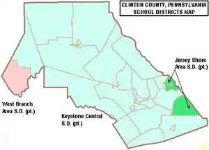
Public school districts
- Jersey Shore Area School District (also in Lycoming County)
- Keystone Central School District (also in Centre County)
- West Branch Area School District (also in Clearfield County)
Recreation
There are five Pennsylvania state parks in Clinton County.
- Bucktail State Park Natural Area is a 75-mile (121 km) scenic route along Pennsylvania Route 120 stretching from Lock Haven to Emporium in Cameron County.
- Hyner Run State Park
- Hyner View State Park
- Kettle Creek State Park
- Ravensburg State Park
Communities
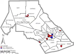
Under Pennsylvania law, there are four types of incorporated municipalities: cities, boroughs, townships, and, in at most two cases, towns. The following cities, boroughs and townships are located in Clinton County:
City
- Lock Haven (county seat)
Boroughs
Townships
Census-designated places
Census-designated places are geographical areas designated by the U.S. Census Bureau for the purposes of compiling demographic data. They are not actual jurisdictions under Pennsylvania law. Other unincorporated communities, such as villages, may be listed here as well.
Population ranking
The population ranking of the following table is based on the 2010 census of Clinton County.[14]
† county seat
| Rank | City/Town/etc. | Municipal type | Population (2010 Census) |
|---|---|---|---|
| 1 | † Lock Haven | City | 9,772 |
| 2 | Mill Hall | Borough | 1,613 |
| 3 | Avis | Borough | 1,484 |
| 4 | Dunnstown | CDP | 1,360 |
| 5 | Flemington | Borough | 1,330 |
| 6 | Renovo | Borough | 1,228 |
| 7 | Castanea | CDP | 1,125 |
| 8 | Rauchtown (partially in Lycoming County) | CDP | 726 |
| 9 | Beech Creek | Borough | 701 |
| 10 | McElhattan | CDP | 598 |
| 11 | Lamar | CDP | 562 |
| 12 | Rote | CDP | 507 |
| 13 | Loganton | Borough | 468 |
| 14 | South Renovo | Borough | 439 |
References
- "PHMC Historical Markers Search" (Searchable database). Pennsylvania Historical and Museum Commission. Commonwealth of Pennsylvania. Retrieved 2014-01-25.
- "State & County QuickFacts". United States Census Bureau. Archived from the original on July 8, 2011. Retrieved November 16, 2013.
- "Find a County". National Association of Counties. Archived from the original on 2011-05-31. Retrieved 2011-06-07.
- Gannett, Henry (1905). The Origin of Certain Place Names in the United States. Govt. Print. Off. pp. 85.
- "2010 Census Gazetteer Files". United States Census Bureau. August 22, 2012. Retrieved March 6, 2015.
- summit type feature
- "Population and Housing Unit Estimates". Retrieved October 9, 2018.
- "U.S. Decennial Census". United States Census Bureau. Retrieved March 6, 2015.
- "Historical Census Browser". University of Virginia Library. Retrieved March 6, 2015.
- Forstall, Richard L., ed. (March 24, 1995). "Population of Counties by Decennial Census: 1900 to 1990". United States Census Bureau. Retrieved March 6, 2015.
- "Census 2000 PHC-T-4. Ranking Tables for Counties: 1990 and 2000" (PDF). United States Census Bureau. April 2, 2001. Retrieved March 6, 2015.
- "U.S. Census website". United States Census Bureau. Retrieved 2008-01-31.
- "Office of Management and Budget". whitehouse.gov. Retrieved 3 April 2018.
- "2010 U.S. Census website". United States Census Bureau. Retrieved 2013-02-10.
- Leip, David. "Dave Leip's Atlas of U.S. Presidential Elections". uselectionatlas.org.
- The leading "other" candidate, Progressive Theodore Roosevelt, received 1,926 votes, while Socialist candidate Eugene Debs received 613 votes, Prohibition candidate Eugene Chafin received 77 votes, and Socialist Labor candidate Arthur Reimer received 5 votes.
External links
| Wikimedia Commons has media related to Clinton County, Pennsylvania. |
- Clinton County Government Homepage
- Open Access edition of The History of Centre and Clinton counties, Pennsylvania (1883) by John Blair Linn at the Penn State University Library website
Municipalities and communities of Clinton County, Pennsylvania, United States | ||
|---|---|---|
| City | | |
| Boroughs | ||
| Townships | ||
| CDPs | ||
| Unincorporated communities | ||
| Footnotes | ‡This populated place also has portions in an adjacent county | |
| ||

| Authority control |
|---|