Louisburg, Minnesota
Louisburg is a city in Lac qui Parle County, Minnesota, United States. The population was 47 at the 2010 census.[6]
Louisburg | |
|---|---|
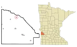 Location of Louisburg, Minnesota | |
| Coordinates: 45°9′57″N 96°10′20″W | |
| Country | United States |
| State | Minnesota |
| County | Lac qui Parle |
| Area | |
| • Total | 0.25 sq mi (0.66 km2) |
| • Land | 0.25 sq mi (0.66 km2) |
| • Water | 0.00 sq mi (0.00 km2) |
| Elevation | 1,040 ft (317 m) |
| Population | |
| • Total | 47 |
| • Estimate (2019)[3] | 44 |
| • Density | 173.23/sq mi (66.86/km2) |
| Time zone | UTC-6 (Central (CST)) |
| • Summer (DST) | UTC-5 (CDT) |
| ZIP code | 56256 |
| Area code(s) | 320 |
| FIPS code | 27-38258[4] |
| GNIS feature ID | 0647223[5] |
History
Louisburg was platted in 1887.[7] A post office was established at Louisburg in 1888, and remained in operation until it was discontinued in 1992.[8]
Geography
According to the United States Census Bureau, the city has a total area of 0.30 square miles (0.78 km2), all of it land.[9]
Demographics
| Historical population | |||
|---|---|---|---|
| Census | Pop. | %± | |
| 1910 | 88 | — | |
| 1920 | 99 | 12.5% | |
| 1930 | 77 | −22.2% | |
| 1940 | 94 | 22.1% | |
| 1950 | 93 | −1.1% | |
| 1960 | 91 | −2.2% | |
| 1970 | 75 | −17.6% | |
| 1980 | 52 | −30.7% | |
| 1990 | 42 | −19.2% | |
| 2000 | 26 | −38.1% | |
| 2010 | 47 | 80.8% | |
| 2019 (est.) | 44 | [3] | −6.4% |
| U.S. Decennial Census[10] | |||
2010 census
As of the census[2] of 2010, there were 47 people, 18 households, and 16 families living in the city. The population density was 156.7 inhabitants per square mile (60.5/km2). There were 30 housing units at an average density of 100.0 per square mile (38.6/km2). The racial makeup of the city was 93.6% White, 4.3% Asian, and 2.1% from other races. Hispanic or Latino of any race were 2.1% of the population.
There were 18 households, of which 33.3% had children under the age of 18 living with them, 72.2% were married couples living together, 16.7% had a female householder with no husband present, and 11.1% were non-families. 11.1% of all households were made up of individuals, and 11.2% had someone living alone who was 65 years of age or older. The average household size was 2.61 and the average family size was 2.81.
The median age in the city was 46.3 years. 27.7% of residents were under the age of 18; 8.4% were between the ages of 18 and 24; 12.8% were from 25 to 44; 34.1% were from 45 to 64; and 17% were 65 years of age or older. The gender makeup of the city was 46.8% male and 53.2% female.
2000 census
At the 2000 census,[4] there were 26 people, 13 households and 7 families living in the city. The population density was 85.0 per square mile (32.4/km2). There were 29 housing units at an average density of 94.8 per square mile (36.1/km2). The racial makeup of the city was 96.15% White and 3.85% Asian.
There were 13 households, of which 23.1% had children under the age of 18 living with them, 61.5% were married couples living together, and 38.5% were non-families. 38.5% of all households were made up of individuals, and 15.4% had someone living alone who was 65 years of age or older. The average household size was 2.00 and the average family size was 2.63.
19.2% of the population was under the age of 18, 15.4% from 25 to 44, 26.9% from 45 to 64, and 38.5% who were 65 years of age or older. The median age was 52 years. For every 100 females, there were 136.4 males. For every 100 females age 18 and over, there were 110.0 males.
The median household income was $18,750, and the median family income was $24,375. Males had a median income of $25,417 versus $35,625 for females. The per capita income for the city was $14,535. None of the population or the families were below the poverty line.
References
- "2019 U.S. Gazetteer Files". United States Census Bureau. Retrieved July 26, 2020.
- "U.S. Census website". United States Census Bureau. Retrieved 2012-11-13.
- "Population and Housing Unit Estimates". United States Census Bureau. May 24, 2020. Retrieved May 27, 2020.
- "U.S. Census website". United States Census Bureau. Retrieved 2008-01-31.
- "US Board on Geographic Names". United States Geological Survey. 2007-10-25. Retrieved 2008-01-31.
- "2010 Census Redistricting Data (Public Law 94-171) Summary File". American FactFinder. United States Census Bureau. Retrieved 27 April 2011.
- Warren Upham (1920). Minnesota Geographic Names: Their Origin and Historic Significance. Minnesota Historical Society. p. 290.
- "Lac qui Parle County". Jim Forte Postal History. Retrieved 17 July 2015.
- "US Gazetteer files 2010". United States Census Bureau. Archived from the original on 2012-01-25. Retrieved 2012-11-13.
- "Census of Population and Housing". Census.gov. Retrieved June 4, 2015.
Municipalities and communities of Lac qui Parle County, Minnesota, United States | ||
|---|---|---|
| Cities | 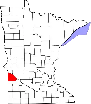 Map of Minnesota highlighting Lac qui Parle County | |
| Townships | ||
| Unincorporated communities | ||
| Footnotes | ‡This populated place also has portions in an adjacent county or counties | |
| ||
