Maxwell Township, Lac qui Parle County, Minnesota
Maxwell Township is a township in Lac qui Parle County, Minnesota, United States. The population was 206 at the 2000 census.
Maxwell Township, Minnesota | |
|---|---|
 Maxwell Township, Minnesota Location within the state of Minnesota  Maxwell Township, Minnesota Maxwell Township, Minnesota (the United States) | |
| Coordinates: 44°51′12″N 96°2′31″W | |
| Country | United States |
| State | Minnesota |
| County | Lac qui Parle |
| Area | |
| • Total | 36.3 sq mi (94.0 km2) |
| • Land | 36.2 sq mi (93.8 km2) |
| • Water | 0.1 sq mi (0.2 km2) |
| Elevation | 1,089 ft (332 m) |
| Population (2000) | |
| • Total | 206 |
| • Density | 5.7/sq mi (2.2/km2) |
| Time zone | UTC-6 (Central (CST)) |
| • Summer (DST) | UTC-5 (CDT) |
| FIPS code | 27-41084[1] |
| GNIS feature ID | 0664930[2] |
Maxwell Township was organized in 1878, and named for Joseph Henry Maxwell, an early settler.[3]
Geography
According to the United States Census Bureau, the township has a total area of 36.3 square miles (94.0 km2), of which 36.2 square miles (93.8 km2) is land and 0.1 square mile (0.2 km2) (0.19%) is water.
Demographics
As of the census[1] of 2000, there were 206 people, 76 households, and 56 families residing in the township. The population density was 5.7 people per square mile (2.2/km2). There were 84 housing units at an average density of 2.3/sq mi (0.9/km2). The racial makeup of the township was 100.00% White.
There were 76 households, out of which 38.2% had children under the age of 18 living with them, 69.7% were married couples living together, 2.6% had a female householder with no husband present, and 26.3% were non-families. 26.3% of all households were made up of individuals, and 14.5% had someone living alone who was 65 years of age or older. The average household size was 2.71 and the average family size was 3.32.
In the township the population was spread out, with 32.5% under the age of 18, 4.9% from 18 to 24, 23.3% from 25 to 44, 27.2% from 45 to 64, and 12.1% who were 65 years of age or older. The median age was 40 years. For every 100 females, there were 98.1 males. For every 100 females age 18 and over, there were 101.4 males.
The median income for a household in the township was $36,250, and the median income for a family was $41,250. Males had a median income of $23,750 versus $23,125 for females. The per capita income for the township was $16,161. About 5.2% of families and 7.4% of the population were below the poverty line, including 7.0% of those under the age of eighteen and none of those 65 or over.
References
- "U.S. Census website". United States Census Bureau. Retrieved 2008-01-31.
- "US Board on Geographic Names". United States Geological Survey. 2007-10-25. Retrieved 2008-01-31.
- Warren Upham (1920). Minnesota Geographic Names: Their Origin and Historic Significance. Minnesota Historical Society. p. 291.
Municipalities and communities of Lac qui Parle County, Minnesota, United States | ||
|---|---|---|
| Cities | 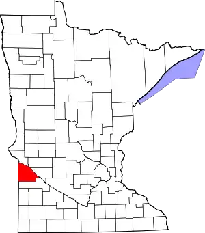 Map of Minnesota highlighting Lac qui Parle County | |
| Townships | ||
| Unincorporated communities | ||
| Footnotes | ‡This populated place also has portions in an adjacent county or counties | |
| ||
