Lower South East Marine Park
Lower South East Marine Park is a marine protected area in the Australian state of South Australia located in the state's coastal waters in the state’s south-east adjoining the border with the state of Victoria.[1]
| Lower South East Marine Park South Australia | |
|---|---|
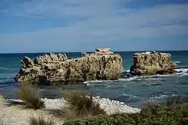
 Mounce and Battye Rocks are located within the marine park | |
 Lower South East Marine Park | |
| Nearest town or city | Mount Gambier |
| Coordinates | 37°53′35″S 140°20′06″E[1] |
| Established | 29 January 2009[2] |
| Area | 360 square kilometres (140 sq mi)[3] |
| Managing authorities | Department of Environment and Water |
| Website | Lower South East Marine Park |
The Lower South East Marine Park consists of two parts which extend from ‘median high water’ to the edge of coastal waters. The first part extends from Cape Buffon in the north-west to just north of Cape Banks in the south-east adjoining coastline within the boundary of the Canunda National Park. The second part which is largely within Discovery Bay extends from “Port MacDonnell Bay” (sic) in the west to the state border in the east. This part “partially overlays” the southern boundary of the part of the Piccaninnie Ponds Conservation Park which extends to low water.[3][4]
The marine park was established on 29 January 2009 by proclamation under the Marine Parks Act 2007 and its extent was subsequently varied on 23 July 2009.[2][5]
The marine park is divided into zones to managing the marine environment to ensure varying degrees of “protection for habitats and biodiversity” and varying levels of “ecologically sustainable development and use” as follows:[3]
- Two “sanctuary zones” adjoining the coastlines with the Canunda National Park and the Piccaninnie Ponds Conservation Park where “the removal or harm of plants, animals or marine products” is prohibited,
- Three “habitat protection zones” where “activities and uses that do not harm habitats or the functioning of ecosystems” are only permitted,
- Two “general managed use zones” where “ecologically sustainable development and use” is allowed, and
- Two “special purpose areas” which do overlap some of the above zones and are concerned with "harbor activities" near Cape Buffon and with "shore-based recreational line fishing" on the coastline with the Piccaninnie Ponds Conservation Park.
As of 2016, the marine park has been classified under International Union for Conservation of Nature system of protected area categories with the “sanctuary zones” being IUCN Category II, the “habitat protection zones” being IUCN Category IV and the “general managed use zones” being IUCN Category VI.[6][3]
See also
References
- "Search result for 'Lower South East Marine Park ' with the following datasets being selected - 'State Marine Park Network', 'Rock Lobster Sanctuaries', 'SA Government Regions' and 'Gazetteer'". Location SA Map Viewer. The Government of South Australia. Retrieved 6 November 2019.
- "Marine Parks Proclamation 2009 under section 10 of the Marine Parks Act 2007" (PDF). THE SOUTH AUSTRALIAN GOVERNMENT GAZETTE. Government of South Australia. 29 January 2009. p. 481. Retrieved 15 January 2018.
- "LOWER SOUTH EAST MARINE PARK MANAGEMENT PLAN 2012" (PDF). Department of Environment, Water and Natural Resources, Government of South Australia. 2012. pp. 3, 5, 6 and 18-21. Retrieved 15 January 2018.
- "Ramsar Management Plan for Piccaninnie Ponds Karst Wetlands" (PDF). Department of Environment and Natural Resources, Government of South Australia. 2011. pp. 316–17. Retrieved 16 January 2018.
- "Marine Parks Variation Proclamation 2009 under section 10 of the Marine Parks Act 2007". THE SOUTH AUSTRALIAN GOVERNMENT GAZETTE. Government of South Australia. 23 July 2009. p. 3286. Retrieved 15 January 2018.
- "Marine Protected Areas in coastal waters of South Australia". CAPAD 2016. Australian government. Retrieved 15 January 2018.