Māngere Mountain
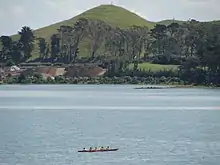
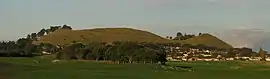
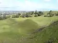
Māngere Mountain is a volcanic cone in Mangere, Auckland. Located within Māngere Domain, it is one of the largest volcanic cones in the Auckland volcanic field, with a peak 106 metres (348 ft) above sea level. It was the site of a major pā (Māori fortified settlement) and many of the pā's earthworks are still visible. It has extensive panoramic views of Auckland from its location in the southeastern portion of the city's urban area.[1][2] It is also known as Te Pane o Mataoho.[3]
| Māngere Mountain | |
|---|---|
 Māngere Mountain seen from Ambury Regional Park | |
| Highest point | |
| Elevation | 106 m (348 ft) |
| Coordinates | 36°56′59″S 174°46′59″E |
| Geography | |
| Geology | |
| Volcanic arc/belt | Auckland volcanic field |
The volcano features two large craters. It has a wide crater with a lava dome near its centre, a feature shared by no other volcano in Auckland. It first erupted approximately 70,000 years ago.[1][4]
The mountain is one of the largest and best preserved of Auckland's volcanic cones. Many archaeological features remain, including kumara pits, garden terraces, walled garden mounds and stone boundary walls.[2]
Near the mountain to the southwest is Mangere Lagoon, filling another volcanic crater.
 The central lava dome, or tholoid.
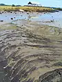 Pahoehoe lava flow from Mangere Mountain at nearby Ambury Regional Park
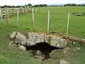 One of many small lava caves in lava flows from Mangere Mountain, at Ambury Regional Park
References
- "Mangere Mountain". Auckland Council. Retrieved 17 May 2014.
- "Mangere Mountain Education Centre". NZMuseums. Museum of New Zealand Te Papa Tongarewa. Retrieved 17 May 2014.
- Field, Michael (23 August 2012). "Maori names restored at Auckland landmarks". Stuff. Retrieved 28 September 2017.
- Mountain, Māngere. "Mangere Mountain History Formation | Mangere Mountain". Māngere Mountain. Retrieved 9 April 2019.
- Volcanoes of Auckland: A Field Guide. Hayward, B.W.; Auckland University Press, 2019, 335 pp. ISBN 0-582-71784-1.
External links
| Wikimedia Commons has media related to Māngere Mountain. |
- Mangere Mountain Education Centre
- Historic Mangere Mountain, Department of Conservation
- Mt Mangere, Geological Society of New Zealand
- Photographs of Mangere Mountain held in Auckland Libraries' heritage collections.