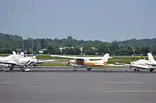
Manassas Regional Airport
Manassas Regional Airport (IATA: MNZ[1][2], ICAO: KHEF, FAA LID: HEF) (Harry P. Davis Field) is five miles southwest of the center of Manassas.[3] Manassas Regional Airport is the largest regional airport in Virginia, and it is located 30 miles (48 km) from Washington, D.C.
Manassas Regional Airport Harry P. Davis Field | |||||||||||||||
|---|---|---|---|---|---|---|---|---|---|---|---|---|---|---|---|
 | |||||||||||||||
| Summary | |||||||||||||||
| Airport type | Public | ||||||||||||||
| Owner | City of Manassas | ||||||||||||||
| Serves | Manassas, Virginia | ||||||||||||||
| Elevation AMSL | 192 ft / 59 m | ||||||||||||||
| Coordinates | 38°43′17″N 077°30′56″W | ||||||||||||||
| Website | www.manassasregionalairport.aero.... | ||||||||||||||
| Map | |||||||||||||||
 HEF  HEF | |||||||||||||||
| Runways | |||||||||||||||
| |||||||||||||||
| Statistics (2006) | |||||||||||||||
| |||||||||||||||
History

An airport for Manassas was proposed in 1930, when the mayor was Harry P. Davis.[4] It was built in 1931 on 94 acres (0.38 km2)[5] along Virginia Route 234, in the area now known as Manaport Shopping Center. Originally owned privately, the Town of Manassas bought the airport in 1945.[6] Due to airport activity and nearby housing development, the airport moved to its current location in 1964. The new airport opened with a single 3,700-by-100-foot (1,128 m × 30 m) paved runway. In 1992, the city purchased a control tower from Centennial Airport near Denver and reassembled it at Manassas Regional Airport. A new terminal was built in 1996.[7]
Facilities
The airport covers 888 acres (359 ha) at an elevation of 192 feet (59 m). It has two asphalt runways: 16L/34R is 6,200 x 100 feet (1,737 x 30 m) and 16R/34L is 3,704 x 100 feet (1,129 x 30 m).[3]
In the year ending December 2011 the airport had 85,000 aircraft operations, average 236 per day: 98% general aviation, 1% air taxi and 1% military. 401 aircraft were then based at this airport: 78% single-engine, 10% multi-engine, 7% jet and 5% helicopter.[3]
See also
- Broad Run/Airport (VRE station)
- Colgan Air (headquarters formerly located on airport grounds)
- City of Manassas
References
- Great Circle Mapper (IATA: MNZ)
- "Airline and Airport Code Search". IATA. Retrieved 12 November 2015.
- FAA Airport Form 5010 for HEF PDF, effective 2013-01-10
- "Manassas Airport Dedication Is Set: State and Federal Officials to Attend Ceremony on Wednesday". The Washington Post. June 5, 1932. p. 8. ProQuest 150345581.
- "Manassas Airport to Be Begun Soon: Citizens Buy 94 Acres for Emergency Landing". The Washington Post. June 16, 1931. p. 22. ProQuest 150228975.
- "Leased Airport Is Purchased By Manassas". The Washington Post. October 21, 1945. p. M3. ProQuest 151778685.
- Airport History at City of Manassas website
External links
| Wikimedia Commons has media related to Manassas Regional Airport. |
- Manassas Regional Airport at City of Manassas website
- Bussmann Aviation
- FAA Airport Diagram (PDF), effective January 28, 2021
- FAA Terminal Procedures for HEF, effective January 28, 2021
- Resources for this airport:
- FAA airport information for HEF
- AirNav airport information for KHEF
- ASN accident history for HEF
- FlightAware airport information and live flight tracker
- NOAA/NWS weather observations: current, past three days
- SkyVector aeronautical chart, Terminal Procedures
