Manchester, Washington
Manchester is an unincorporated community and census-designated place (CDP) in Kitsap County, Washington, United States. The population was 5,413 at the 2010 census.[3]
Manchester, Washington | |
|---|---|
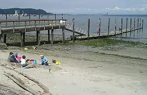 The public pier and waterfront at Manchester during a summer low tide. Bainbridge Island is in the background on the left, and Seattle is far away on the right. | |
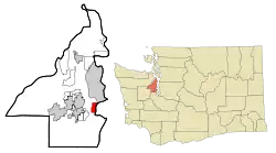 Location of Manchester, Washington | |
| Coordinates: 47°33′8″N 122°33′0″W | |
| Country | United States |
| State | Washington |
| County | Kitsap |
| Area | |
| • Total | 5.65 sq mi (14.64 km2) |
| • Land | 2.93 sq mi (7.58 km2) |
| • Water | 2.73 sq mi (7.06 km2) |
| Elevation | 30 ft (9 m) |
| Population (2010) | |
| • Total | 5,413 |
| • Density | 1,851/sq mi (714.6/km2) |
| Time zone | UTC-8 (Pacific (PST)) |
| • Summer (DST) | UTC-7 (PDT) |
| ZIP code | 98353 |
| Area code(s) | 360 |
| FIPS code | 53-42450[1] |
| GNIS feature ID | 1512426[2] |
History
Manchester was established in the 1860s and was originally known as "Brooklyn", after the borough in New York City. The name was changed to "Manchester" in 1892 in honor of the city of Manchester, England. Manchester was accessible by land via Shelton/Allyn/Belfair, but the main population center in the region, Seattle, had only boat access. After a permanent dock was built in 1908, regular steamboat service connected Manchester to nearby communities like Colby, Southworth, and Harper, and to Seattle across the water.
From 1925 to 1936, a ferry route across Puget Sound connected Manchester with Alki Point in West Seattle. When the Alki Point dock washed away in 1936, the Seattle terminus was shifted to Colman Dock on the Seattle central waterfront.[4] Ferry service was discontinued in 1949 and has never resumed.
In 1940, the US Navy built a pier nearby for refueling ships. The fuel pier saw heavy use during World War II and still operates today.
In 1953, the library in Manchester was slated for destruction. The town pulled together and a new library was constructed in 1954. Today, Manchester has excellent views of Seattle, Mount Rainier, and Puget Sound, has a public boat launch, a boat parade on the opening day of boating season, and sponsors salmon bakes at the Manchester library.
Geography
Manchester is located in southeastern Kitsap County at 47°33′08″N 122°33′00″W (47.552305, -122.549984).[5] It is on the west side of Puget Sound from Rich Passage in the north to Yukon Harbor in the south. Manchester is 6 miles (10 km) east of Port Orchard, the Kitsap county seat. Manchester State Park is to the north, just outside the CDP area.
According to the United States Census Bureau, the Manchester CDP has a total area of 5.6 square miles (14.6 km2), of which 2.9 square miles (7.6 km2) are land and 2.7 square miles (7.1 km2), or 48.25%, are water. Besides Manchester proper, the CDP contains the smaller communities of Colchester and Colby.
Climate
This region experiences warm (but not hot) and dry summers, with no average monthly temperatures above 71.6 °F. According to the Köppen Climate Classification system, Manchester has a warm-summer Mediterranean climate, abbreviated "Csb" on climate maps.[6]
Demographics
As of the census[1] of 2000, there were 4,958 people, 1,819 households, and 1,395 families residing in the CDP. The population density was 1,693.4 people per square mile (653.3/km2). There were 1,913 housing units at an average density of 653.4/sq mi (252.1/km2). The racial makeup of the CDP was 87.7% White, 1.3% African American, 1.1% Native American, 2.7% Asian, 0.9% Pacific Islander, 1.4% from other races, and 5.0% from two or more races. Hispanic or Latino of any race were 3.8% of the population.
There were 1,819 households, out of which 39.4% had children under the age of 18 living with them, 62.7% were married couples living together, 9.8% had a female householder with no husband present, and 23.3% were non-families. 17.3% of all households were made up of individuals, and 5.3% had someone living alone who was 65 years of age or older. The average household size was 2.73 and the average family size was 3.06.
In the CDP, the population was spread out, with 28.9% under the age of 18, 6.4% from 18 to 24, 31.5% from 25 to 44, 24.7% from 45 to 64, and 8.5% who were 65 years of age or older. The median age was 36 years. For every 100 females, there were 96.5 males. For every 100 females age 18 and over, there were 93.7 males.
The median income for a household in the CDP was $52,213, and the median income for a family was $56,118. Males had a median income of $39,695 versus $26,875 for females. The per capita income for the CDP was $21,946. About 4.9% of families and 5.5% of the population were below the poverty line, including 7.7% of those under age 18 and 1.5% of those age 65 or over.
Notes
- "U.S. Census website". United States Census Bureau. Retrieved 2008-01-31.
- "Manchester". Geographic Names Information System. United States Geological Survey.
- "Geographic Identifiers: 2010 Census Summary File 1 (G001), Manchester CDP, Washington". American FactFinder. U.S. Census Bureau. Archived from the original on February 13, 2020. Retrieved July 1, 2019.
- Kline and Bayless, Ferryboats-A Legend on Puget Sound, at pages 134, 135, 211, and 374.
- "US Gazetteer files: 2010, 2000, and 1990". United States Census Bureau. 2011-02-12. Retrieved 2011-04-23.
- Climate Summary for Manchester, Washington
References
- Kline, Mary S., and Bayless, G.A., Ferryboats -- A Legend on Puget Sound, Bayless Books, Seattle, WA 1983 ISBN 0-914515-00-4
Further reading
- Kitsap County Historical Society, Kitsap County: A History, 2nd edition, 1981.
External links
| Wikivoyage has a travel guide for Manchester, Washington. |
- Manchester Subarea Plan (Includes History)
- Kitsap Peninsula Visitor Information - Manchester
- Manchester State Park
Municipalities and communities of Kitsap County, Washington, United States | ||
|---|---|---|
| Cities | 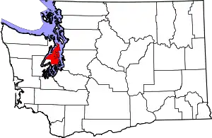 Map of Washington highlighting Kitsap County | |
| CDPs | ||
| Other unincorporated communities | ||
| Indian reservation | ||
| ||