Manimala River
Manimala River is a 92 km long river in South and Central Kerala. The river used to be wrongly considered as a tributary of Pamba River before satellite maps became popular, but this is incorrect. Manimala does not flow into Pamba, but a branch of Pamba flows into Manimala from Kuthiathode and joins Manimala at Kallunkal, later branches out at again from Manimala at Nedumpuram and flows through Niranam, Thalavady, Edathua, Changankary, Champakulam, Nedumudy, Chennamkary, and finally Kainakary and empties into Vembanad lake. This branch again links with Manimala river at Chennankary in a short, but broad connection known as Munnattumukham. Manimala is a separate independent river for all geographical purposes. It has its origin on the Muthavara Hills (1156 feet above main sea level) on the Western Ghats, It is with a length of about 90 km and a catchment area of about 847 km2. in Idukki district of Kerala, India. The river passes through the districts of Kottayam, Pathanamthitta and Alappuzha districts.[1] Yendayar, Koottickal, Mundakayam, Erumeli, Manimala, Kottangal, Kulathurmoozy, Vaipur, Mallappally, Keezhvaipur, Thuruthicad, komalam,/kuranjoor kadavuKallooppara, vallamkulam, Kattode & Kuttoor (Outskirts of Thiruvalla town), Pulikeezh, Nedumpuram, Neerettupuram, Amichakary, Muttar, Kidangara, Pulincunnoo, Veliyanadu, Ramankary, Mankompu lie on the banks of Manimala River. Manimala splits after Kidangara into two branches. Second branch flows via Kunnamkary, Kavalam and Kainakary to Vembanad lake. Its running length is estimated at 92 km. It empties itself into the Vembanad Lake. It is one of the four major rivers which do not have direct outlet to sea as these rivers (Meenachil, Pamba, Manimala, Achankovil) empty into the vast Vembanad lake. This huge lake has just two outlets, one at Thottappaly Spillway and second at Thannermukkom Bund, both man made barriers, built to prevent incoming seawater during high tides, which otherwise would render the low lying paddyfields (average 2.5 meters below sea level) uncultivable.
| Manimala River Pullakayar, Vallapuzha , Vallabhaipuzha | |
|---|---|
 Manimala river near Cheruvally | |
| Native name | മണിമലയാർ (Malayalam) |
| Location | |
| Country | India |
| State | Kerala |
| Districts | Kottayam, Pathanamthitta, Alappuzha |
| Cities | Mundakayam, Manimala, Kanjirappally, Mallappally, Vennikkulam, Kallooppara, Kaviyoor, Vallamkulam Thiruvalla, Thalavadi, Kidangara, Pulinkunnu, Edathua, Champakulam etc. |
| Physical characteristics | |
| Source | |
| • location | Muthavara hills, Western ghats |
| • elevation | 2,500 ft (760 m) |
| Mouth | |
• location | [[Empties into Vembanad Lake at Kainakary through two branches which separates after Kidangara, one via Pulinkunnu, Mankompu second via Veliyanadu, Kavalam. A branch of Pamba splits at Kuthiathodu and joins Manimala river at Kallunkal flows together for nearly five Kilometers and branches out again at Nedumpuram and flows along Niranam, Thalavady, Edathua, Champakulam, Nedumudy, Chennamkary and joins Vembanad lake at Kainakary.]] |
| Length | 91.73 km (57.00 mi) |
| Basin size | 802.90 km2 (310.00 sq mi) |
| Basin features | |
| Landmarks | Kallooppara Bhagavathy temple, Kaviyoor Mahadevar Temple, [[Nannoor Devi Temple]]. |
Niranam is historically known as an ancient inland port at the confluence of Manimala River and Pamba River. At Kaviyoor ancient rock-cut cave temples can still be seen.
Manimala River has been an important water way of Central Travancore. Rising in the hills of Kottayam-Idukki ranges, running westward, the river joins the plains at Manimala junction and then the flows through the midland plains and through the Kuttanad rice bowl area. Sand mining on the river bed has led to depletion of the water ways of the river. Pollution is also another issue.
Gallery
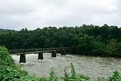
 Manimala River, photographed from Pazhayidom bridge
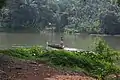 A canoe in Manimalayar
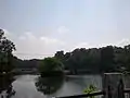 At Manimala
References
| Wikimedia Commons has media related to Manimala River. |
- "About the Rivers of Kerala". Retrieved 14 February 2010.
Ichthyodiversity of Manimala River
| Rivers |
| ||||
|---|---|---|---|---|---|
| Lakes, dams and reservoirs | |||||
| Waterfalls | |||||
| Beaches | |||||
| Boats |
| ||||
| Related topics | |||||
| Hydrography of surrounding areas |
| ||||
