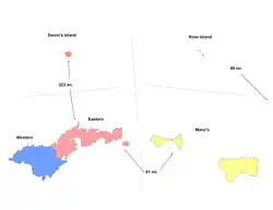
Manuʻa District
The Manuʻa District is one of the three primary administrative divisions of American Samoa. The district comprises the Manuʻa Islands, which are located approximately 61 miles east of the main island, Tutuila. The Manuʻa District is considered to be a county-equivalent by the U.S. Census Bureau.[1]

In 2010, the Manuʻa District had a per capita income of $5,441[2] — this makes the Manuʻa District the county / county-equivalent with the lowest-per capita income in the entire United States.
District divisions
Manu'a District is further divided into five counties.
Demographics
| Year | Pop. | ±% |
|---|---|---|
| 1900 | 1,756 | — |
| 1912 | 1,797 | +2.3% |
| 1920 | 1,871 | +4.1% |
| 1930 | 2,147 | +14.8% |
| 1940 | 2,597 | +21.0% |
| 1950 | 2,819 | +8.5% |
| 1960 | 2,695 | −4.4% |
| 1970 | 2,112 | −21.6% |
| 1980 | 1,732 | −18.0% |
| 1990 | 1,714 | −1.0% |
| 2000 | 1,378 | −19.6% |
| 2010 | 1,143 | −17.1% |
| U.S. Decennial Census[3] | ||
Manu'a District was first recorded beginning with the 1900 U.S. Census. No census was taken in 1910, but a special census was taken in 1912. Regular decennial censuses were taken beginning in 1920.[4] Its population zenith was in 1950. As of 2000–10, it had a population lower than when first recorded in 1900.
References
- https://www2.census.gov/geo/pdfs/reference/GARM/Ch4GARM.pdf States, Counties, and Statistically Equivalent Entities (Chapter 4). Census.gov. Retrieved July 5, 2019.
- https://factfinder.census.gov/faces/tableservices/jsf/pages/productview.xhtml?pid=DEC_10_DPAS_ASDP3&prodType=table Archived 2020-02-14 at Archive.today American FactFinder. Profile of Selected Economic Characteristics: 2010. 2010 American Samoa Demographic Profile Data. [Geography set to "Manu'a District, American Samoa"]. Retrieved July 5, 2019.
- "U.S. Decennial Census". Census.gov. Retrieved June 6, 2013.
- https://www2.census.gov/prod2/decennial/documents/41084484v3ch10.pdf