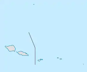
Vailoatai, American Samoa
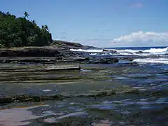
Vailoatai is a village in southwestern Tutuila, the main island of American Samoa. It is located on the eastern end of Leone Bay. The village is known for its beautiful malae (ceremonial village-green) located along the island's rugged southern coast, lined by the fale tali malo (guest houses) of its village chiefs.
Vailoatai | |
|---|---|
Village | |
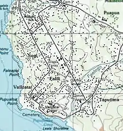 Topo Map of Vailoatai | |
| Etymology: Samoan: "long river, seaside"[1] | |
| Nickname(s): Tuālā | |
| Motto(s): Sā Le Fo’i | |
 Vailoatai | |
| Coordinates: 14°21′05″S 170°46′55″W | |
| Country | |
| Territory | |
| Island | Tutuila Island |
| Named for | Samoan Mythology |
| Area | |
| • Land | .41 sq mi (1.1 km2) |
| Population (2010) | |
| • Total | 1,447 |
| Time zone | UTC−11 (Samoa Time Zone) |
| ZIP Code | 96799 |
| Area code(s) | +1 684 |
The original name of the village was Tuāulu.[2] In 1926, Tuāulu and another village within the district, named Vailoa, combined to form the Vailoa-tai village.[3] Although the whole of the village is named Vailoatai, residents further divide it into Vailoa-uta and Falīlī areas. [ tai - on the side towards the sea, seaside; uta - on the side towards the land, inland ]
Vailoatai along with Taputimu, Fūtiga and Itū'au (Malaeloa) form the itūmālō (county/district) o Tuālātai. The village serves as the county's principality as the titular head of the district (fa'asuaga) is located here.
Pre-1900 History
Vailoatai is a historical marker of the Ātua (a political district of 'Upolu) migration to Tutuila with many Vailoa family names originating from the Ātua sub-district of Faleālili.[4] The village honors this legacy to this day, recognizing Faleālili in its fa’alupega (charter).[5]
The migration of Ātua families to Tutuila occurred after the defeat of Mālietoa by Tui Ātua[6][7][8] in the 16th century.[9] The political effect of this migration was the addition of six more counties to the original four counties of Tutuila [10] to make the overall organization of the island in keeping with the 'Upolu pattern.[11]
The village and the district became a proponent of this government (mālō) as can be seen in the old Sāmoan parable, the War between Tuveve and Sātele.[12]
Fofō ma Aitūlagi (an honorific that is still used to refer to the entire western district)[13] became Falelima i Sisifo (the five houses of the west), which includes Ālātaua, Fofō, Leāsina (Aitūlagi), Tuālā-tai and Tuālā-uta (Ma’upū) counties.
Sua ma Vāifanua (an honorific that is still used to refer to the entire eastern district)[14] became Falelima i Sasa’e (the five houses of the east), which includes Itū'au Mālosi (ma Nofoa), Ma’opūtasi (Launiusaelua), Sā’ole, Sua and Vāifanua counties.
The HTC Tuā'olo, of the Ma'opūtasi district, counts as the island's tenth county vote (faleagafulu); this was a gift Queen Salamāsina gave to the Tui Manu’a during her installation as Sāmoa's first Tafa'ifā (holder of the four pāpā titles). The Manu'a king would then bestow the title upon the HTC to thank PC Mauga for his hospitality during a visit to Tutuila on his return trip home.[15]
The raising of the U.S. flag over Tutuila saw the end of Ātua's influence over the island, much to the relief of local chiefs who were tired of the endless wars in 'Upolu. They did not want to remain under the control of 'Upolu paramount chiefs, Germany or Great Britain.[16] PC's Sātele and Fuimaono of Vailoa were two of the signatories to the Tutuila Deed of Cession in 1900.[17]
20th Century
In 1907, the village opened its first church with the London Missionary Society (LMS). LMS missionaries note that an elaborate feast marked the special occasion with attendance by dignitaries and family members from around the island.[18]
In 1915, the Manu'a islands suffered severe damage from a hurricane, and the village hosted (among other villages in Tutuila) many residents from Manu'a while relief efforts took place there.[19][20]
In 1934, the Marist Le'alā School for boys opened up in the area between Vailoatai and Taputimu. The school, however, is no longer in existence.[21]
During World War II, U.S. Marines built an airstrip that spanned Leone, Vailoatai and Taputimu. It was started early in 1943 - probably in January. It was completed on 30 September 1943.
Unfortunately, the airstrip could not be used due to prevailing winds, which made take-offs difficult.[22] Only two planes were able to make use of the airstrip before it was abandoned.[23] Government facilities and residential units have since been built over the old airstrip.

In September 1965, Leone High School was opened in the Vailoa-uta area of the village. The school was designed for students from the Western District and transfer students from Manu'a.
Flag Day
Vailoatai has been a proud participant in the territory's annual celebration and commemoration of the April 17, 1900 raising of the American flag, performing the siva ma pese (song and dance) portion of the Flag Day event in 1988, 1998, 2004, 2010, 2012 and 2014.[24][25]
The village regularly participates in the Flag Day's cricket (men's and women's) games and fautasi (traditional Sāmoan long boat) races.
However, the last year the village fautasi, the Fa'asaulala, participated in the annual race was 2014.
The village also performed its siva ma pese program for the Independent State of Sāmoa's celebration of their independence day in 2010 and 2012.
Founding legend
In the book, Ole Manuō o Tala Tu’u ma Fisaga o Tala Ave, the village of Vailoa defeated the cannibal king Tuife’ai with the assistance of two brothers from Ātua,[26] Chiefs Lutu and Solosolo.[27]
Tuāulu was specifically set aside to prepare human sacrifices for Tuife'ai during his reign.[28]
In 1926, Tuāulu and Vailoa combined to form the Vailoatai village.
Tuife'ai is a title that has many tala (legends) from Manu'a, Tutuila and 'Upolu. Sunia notes that the title goes back as far as 500 A.D.,[29] and that the Tuife'ai of that time is responsible for the first failed invasion of the Manu'a kingdom. The title would later establish familial ties with the Mālietoa in the 13th or 14th century.[30]
Historical sites
Asotau is the name of the village malae. It is a historical marker of the Tafa'ifā I’amafana's failed invasion of Manu’a. The counties of Sua and Vāifanua rallied under PC Le’iato to expel I’amafana's forces from Tuālātai, where the king sought refuge under the protection of his relative, PC Sātele, during his retreat from Manu’a.[31]
After a battle ensued,[32][33][34] the conflict was resolved peacefully via a traditional style intercession known as a seumālō.[35][36] King I’amafana and his forces returned to 'Upolu, and the village took the words ‘aso tau’ (Day of War) as the name of its malae to commemorate the event.
If you look closely, you'll notice that the layout of the malae was modeled after that of a Sāmoan chiefly guesthouse. Each of the faletalimalo at the perimeter of the malae is like each of the posts of a guest house, just on a larger scale.[37]
Notable people
- Eni Fa'aua'ā Hunkin Faleomavaega Jr. (August 15, 1943 – February 22, 2017) was an American Samoan politician who served as the territory's lieutenant governor and congressional delegate.
- Fagaoalii Lefagaoali'i Sātele Sunia (c. 1946 – September 5, 2015) was an American Samoan literacy advocate and educator. She served as the First Lady of American Samoa from January 1997 to March 2003 during the tenure of her husband, former Governor Tauese Sunia, who died in office in 2003.
Notable Landmarks
- Faleapoi Point
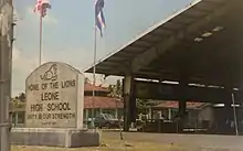
- Leone High School is a senior high school in Vailoatai and Leone, Western District, American Samoa.
- Le'alā Shoreline National Natural Landmark is 35 acres (14 ha) and was designated in 1972.[38]
- Le'alā Sliding Rock is a natural rock formation between Vailoatai and Taputimu, which is a scenic landmark as well as a natural playground or slide. It is located in Tuālātai in the Western District of Tutuila.
References
- Churchill, W. (1913). Geographical Nomenclature of American Samoa. Bulletin of the American Geographical Society, 45(3), 187-193. doi:10.2307/199273
- Fai’ivae, Alex Godinet (2018). Ole Manuō o Tala Tu’u Ma Fisaga o Tala Ave. Amerika Samoa Humanities Council. ISBN 9781546229070.
- Sixteenth Census of the United States: 1940
- Krämer, A. (2000). The Samoa Islands: An Outline of a Monograph with Particular Consideration of German Samoa. Constitution, pedigrees and traditions--. United States: University of Hawaii Press., Page 424
- Krämer, A. (2000). The Samoa Islands: An Outline of a Monograph with Particular Consideration of German Samoa. Constitution, pedigrees and traditions--. United States: University of Hawaii Press., Page 448
- Freeman, J. (1943). THE SEUAO CAVE. The Journal of the Polynesian Society, 52(3), 101-109. Retrieved August 7, 2020, from www.jstor.org/stable/20702941
- Tauiliili, Pemerika L. Anoafale O Le Gagana Ma Le Aganuu, Page 9.
- Henry, Fred (1939). Elementary Geography of the Samoan Islands, Government of American Samoa, Tutuila, Page 10.
- Henry, Fred (1939). Elementary Geography of the Samoan Islands, Government of American Samoa, Tutuila, Page 10.
- Henry, Fred (1939). Elementary Geography of the Samoan Islands, Government of American Samoa, Tutuila, Page 10
- Krämer, A. (2000). The Samoa Islands: An Outline of a Monograph with Particular Consideration of German Samoa. Constitution, pedigrees and traditions--. United States: University of Hawaii Press., Page 424
- P., Vaʻa, L. F. (1987). The Parables of a Samoan Divine: An Analysis of Samoan Texts of the 1860's. Australia: Australian National University, Page 70
- Churchill, W. (1913). Geographical Nomenclature of American Samoa. Bulletin of the American Geographical Society, 45(3), 187-193. doi:10.2307/199273
- Churchill, W. (1913). Geographical Nomenclature of American Samoa. Bulletin of the American Geographical Society, 45(3), 187-193. doi:10.2307/199273
- Sunia, Fofo I.F. (2009). A History of American Samoa. Amerika Samoa Humanities Council. Page 51. ISBN 9781573062992
- Kruse, Line-Noue Mamea (2018). The Pacific Insular Case of American Samoa
- Sunia, Fofo I.F. (2009). A History of American Samoa. Amerika Samoa Humanities Council. Page 363. ISBN 9781573062992
- The London Missionary Society Tutuila Mission. ASHPO(2012).
- American Samoa: A General Report by the Governor, 1925
- Shaffer, Robert J. (2013), American Samoa, 100 Years Under The United States Flag, Page 145
- Fai’ivae, Alex Godinet (2018). Ole Manuō o Tala Tu’u Ma Fisaga o Tala Ave. Amerika Samoa Humanities Council. ISBN 9781546229070.
- Gray, J.A.C. (1960). Amerika Samoa and its Naval Administration. Page 243.
- Sunia, Fofo I.F. (2009). A History of American Samoa. Amerika Samoa Humanities Council. Page 238. ISBN 9781573062992
- http://www.pireport.org/articles/2010/04/12/am-samoa-celebrate-110th-flag
- https://www.samoanews.com/final-cash-count-villages-flag-day
- Fai’ivae, Alex Godinet (2018). Ole Manuō o Tala Tu’u Ma Fisaga o Tala Ave. Amerika Samoa Humanities Council. ISBN 9781546229070.
- Ua Tālā le Ta'ui, Lomiga 1(2009), Page 25.
- Ua Tālā le Ta'ui, Lomiga 1(2009), Page 44.
- Sunia, Fofo I.F. (2009). A History of American Samoa. Amerika Samoa Humanities Council. Page 35. ISBN 9781573062992
- Soʻo, A. (2008). Democracy and Custom in Sāmoa: An Uneasy Alliance. Fiji: IPS Publications, University of the South Pacific, Page 16
- Sunia, Fofo I.F. (2009). A History of American Samoa. Amerika Samoa Humanities Council. Page 52. ISBN 9781573062992
- Lenihan, M. W. (1953). Betwixt the Here and There. United States: Dorrance.
- Brother Herman (1966). Tales of Ancient Samoa: Tala O Le Vavau. (n.p.): Association of the Marist Brothers' Old Boys
- Halloran, P. J. (1939). The Construction of the Samoan Library: Fagatogo, Tutuila, Samoa. United States: U.S. Government Printing Office.
- Sunia, Fofo I.F. (2009). A History of American Samoa. Amerika Samoa Humanities Council. Page 53. ISBN 9781573062992
- Wendt, M. A., Suaalii-Sauni, T. M. (2014). Whispers and Vanities: Samoan Indigenous Knowledge and Religion. United States: Huia Publishers.
- Micah, Van der Ryn (2016). Which Way is Front? Spatial Orientation Complications in Contemporary Samoan Villages
- https://www.nps.gov/subjects/nnlandmarks/site.htm?Site=LESH-AS
- "American Samoa Statistical Yearbook 2015" (PDF). American Samoa Department of Commerce.
| Topics | |||||
|---|---|---|---|---|---|
| Geography | |||||
| Politics | |||||
| Economy |
| ||||
| Culture |
| ||||
| Districts | |||||
| Islands | |||||
| Villages |
| ||||