Marangani District
Marangani District is one of eight districts of the province Canchis in Peru.[1]
Marangani | |
|---|---|
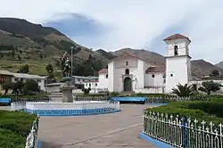 Church in Marangani | |
| Country | |
| Region | Cusco |
| Province | Canchis |
| Founded | August 29, 1834 |
| Capital | Marangani |
| Government | |
| • Mayor | Zenobio Zuñiga Nina |
| Area | |
| • Total | 432.65 km2 (167.05 sq mi) |
| Elevation | 3,709 m (12,169 ft) |
| Population | |
| • Total | 12,404 |
| • Density | 29/km2 (74/sq mi) |
| Time zone | UTC-5 (PET) |
| UBIGEO | 080604 |
Geography
The La Raya mountain range traverses the district. Some of the highest mountains are listed below:[2]
- Anta
- Awkar Utt'aña
- Chaku Apachita
- Chawpi Tiyana
- Chinchina
- Ch'ullu
- Hatun Awkara
- Hatun Wayq'u
- Huch'uy Awkara
- Huch'uy K'uchu
- Kuntur Quta
- Kuntur Sallana
- Laram Quta
- Mulluq'usi
- Pachas Kunka
- Pawka
- Pichaqani
- Pirwa
- Puka Urqu
- Qillqa
- Qillqa Q'asa
- Qullqini
- Sankha Urqu
- Sura Quta
- Urqu Puñuna
- Wayu Kunka
- Wiluyu
- Yana Ranra
- Yana Salla
- Yana Urqu
- Yaritani
The most important river of the district is the Willkanuta which crosses the district from southeast to northwest.[3]
Ethnic groups
The people in the district are mainly indigenous citizens of Quechua descent. Quechua is the language which the majority of the population (80.81%) learnt to speak in childhood, 18.82% of the residents started speaking using the Spanish language (2007 Peru Census).[4]
References
- (in Spanish) Instituto Nacional de Estadística e Informática. Banco de Información Distrital Archived 2008-04-23 at the Wayback Machine. Retrieved April 11, 2008.
- escale.minedu.gob.pe - UGEL map of the Melgar Province (Puno Region)
- escale.minedu.gob.pe - UGEL maps of the Canchis Province (Cusco Region)
- inei.gob.pe Archived 2013-01-27 at the Wayback Machine INEI, Peru, Censos Nacionales 2007, Frequencias: Preguntas de Población: Idioma o lengua con el que aprendió hablar (in Spanish)
| |
|---|---|
| Acomayo | |
| Anta | |
| Calca | |
| Canas | |
| Canchis | |
| Chumbivilcas | |
| Cusco | |
| Espinar | |
| La Convención | |
| Paruro | |
| Paucartambo | |
| Quispicanchi | |
| Urubamba | |
This article is issued from Wikipedia. The text is licensed under Creative Commons - Attribution - Sharealike. Additional terms may apply for the media files.