Ollantaytambo District
Ollantaytambo District is one of seven districts of the province Urubamba in Peru.[1]
Ollantaytambo Ullantaytampu | |
|---|---|
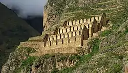 Ruins of granaries on the hillside over Ollantaytambo. | |
 Flag  Coat of arms | |
| Country | |
| Region | Cusco |
| Province | Urubamba |
| Founded | January 2, 1857 |
| Capital | Ollantaytambo |
| Government | |
| • Mayor | Jose Rios Coronel |
| Area | |
| • Total | 640.25 km2 (247.20 sq mi) |
| Elevation | 2,846 m (9,337 ft) |
| Population (2017) | |
| • Total | 10,165 |
| • Density | 16/km2 (41/sq mi) |
| Time zone | UTC-5 (PET) |
| UBIGEO | 081306 |
| Website | muniollantaytambo.gob.pe |
Geography
The Urupampa and Willkapampa mountain ranges traverse the district. The highest peak of the district is Sallqantay at 6,271 metres (20,574 ft). Other mountains are listed below:[2]
- Anawillka Q'asa
- Llama Wasi
- Llawlliyuq
- Marquni
- Masanayuq
- Minasniyuq
- Muyuq
- Pata Kancha
- Pinkuylluna
- Qhispi Rumiyuq
- Q'illu Urqu
- Runtuqucha Q'asa
- Sallqayuq
- Tampu Mach'ay
- Uqhupampa
- Waqra Tanka
- Wamanripayuq
- Waqay Willka
- Wayanay
- Willka Wiqi
- Yana Urqu
- Yuraq Urqu
Ethnic groups
The people in the district are mainly indigenous citizens of Quechua descent. Quechua is the language which the majority of the population (58.55%) learnt to speak in childhood, 38.74% of the residents started speaking using the Spanish language (2007 Peru Census).[3]
References
- (in Spanish) Instituto Nacional de Estadística e Informática. Banco de Información Distrital Archived 2008-04-23 at the Wayback Machine. Retrieved April 11, 2008.
- escale.minedu.gob.pe - UGEL map of the Anta Province (Cusco Region)
- inei.gob.pe Archived 2013-01-27 at the Wayback Machine INEI, Peru, Censos Nacionales 2007, Frequencias: Preguntas de Población: Idioma o lengua con el que aprendió hablar (in Spanish)
External links
- (in Spanish) Official municipal website
| |
|---|---|
| Acomayo | |
| Anta | |
| Calca | |
| Canas | |
| Canchis | |
| Chumbivilcas | |
| Cusco | |
| Espinar | |
| La Convención | |
| Paruro | |
| Paucartambo | |
| Quispicanchi | |
| Urubamba | |
This article is issued from Wikipedia. The text is licensed under Creative Commons - Attribution - Sharealike. Additional terms may apply for the media files.