Santa Teresa District
Santa Teresa District is one of ten districts of the La Convención Province in the Cusco Region of Peru.[1]
Santa Teresa | |
|---|---|
 | |
| Country | |
| Region | Cusco |
| Province | La Convención |
| Founded | October 11, 1957 |
| Capital | Santa Teresa |
| Government | |
| • Mayor | Marcos Reynaldo Vargas Contreras |
| Area | |
| • Total | 1,340.38 km2 (517.52 sq mi) |
| Elevation | 1,550 m (5,090 ft) |
| Population (2017) | |
| • Total | 5,972 |
| • Density | 4.5/km2 (12/sq mi) |
| Time zone | UTC-5 (PET) |
| UBIGEO | 080908 |
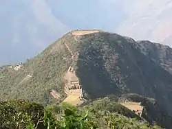
Santa Teresa, Peru is situated 6.5 km northwest of Machu Picchu and is at the axis of several important routes leading to this archeological centre, including alternative paths ways to the ruins (previously the railway was the only means of reaching Machu Picchu). In 1998, a landslide completely buried the town and destroyed the bridge that connected it to Machu Picchu and Cusco, however the bridge has subsequently been rebuilt.
Geography
The Willkapampa mountain range traverses the district. One of the highest peaks of the district is Kiswar at 5,771 m (18,934 ft). The highest peak in the range is Salkantay at 6,271 m (20,574 ft). Other mountains are listed below:[2][3][4]
- Chawpimayu
- Chuqitakarpu
- Kiswar
- Puka Puka
- Phaqcha
- Salkantay
- Qayqu
- Qayqu (near Pumasillu)
See also
References
- (in Spanish) Instituto Nacional de Estadística e Informática. Banco de Información Distrital Archived 2008-04-23 at the Wayback Machine. Retrieved April 11, 2008.
- Jill Neate, Taken from Mountaineering in the Andes, Peru
- escale.minedu.gob.pe - UGEL maps of the La Convención Province and Urubamba Province (Cusco Region)
- Conny Amelunxen, South America, Peru, Cordillera Vilcabamba, Pumasillo Group, Multiple Ascents, AAC publications
- Inka Magik helping with environmental activities and schools in Santa Teresa
| |
|---|---|
| Acomayo | |
| Anta | |
| Calca | |
| Canas | |
| Canchis | |
| Chumbivilcas | |
| Cusco | |
| Espinar | |
| La Convención | |
| Paruro | |
| Paucartambo | |
| Quispicanchi | |
| Urubamba | |